


11:55am Hurricane Ida made landfall as an extremely dangerous category 4 hurricane near Port Fourchon, Louisiana.
Maximum sustained winds of 150 mph and a minimum central pressure of 930 mb (27.46 inches)
------------------
Hurricane Ida intensified in the early morning hours of Sunday to a major hurricane, becoming a Category 3 storm with the 1 a.m. advisory, by 2 a.m. it has been reclassified as a Category 4 storm with winds around 130 mph.
By 4 a.m. those winds had increased further to 140 mph and the gusts close to 165, with pressure dropping rapidly over the last several hours.
It appears that once again Louisiana is dealing with a dangerous storm intensifying all the way to landfall which will occur in south east Louisiana on Sunday afternoon.

In fact, the outer band of the storm have already started to make their way across the eastern half of the state and from here conditions will deteriorate rapidly, so for folks in eastern Louisiana hopefully all preparation has been completed.

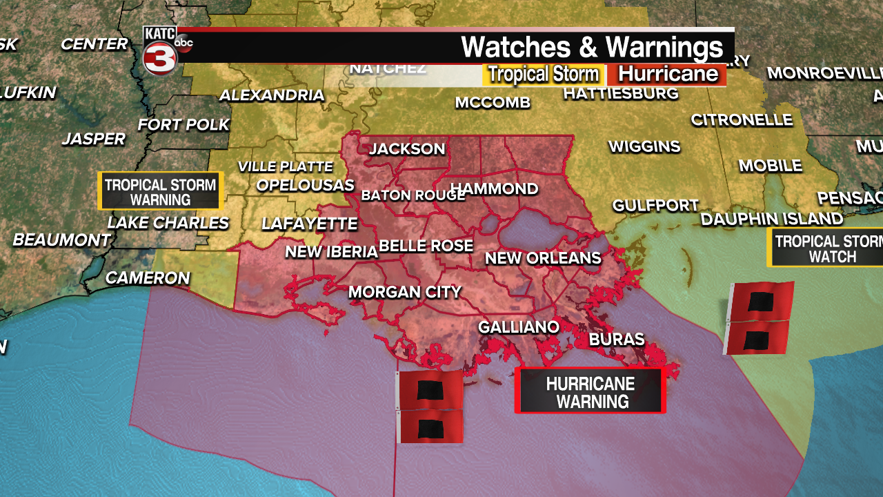
Hurricane Warnings remain in effect for much of the Louisiana coastline and the eastern half of Acadiana, while Acadia, Allen, Avoyelles, Lafayette, Evangeline, and Jeff Davis Parishes are under a Tropical Storm Warning, along with east Cameron.
While central Acadiana has seen their Hurricane Warning converted to a Tropical Storm Warning there's still some decent wind expected for those areas so we'll go through a detailed list of impacts for south central and south east Louisiana.
The storm will move onshore through the early afternoon but impacts will begin long before that, rain bands have already pushed on shore in the eastern part of the state, and some of those rain bands will move across Acadiana through the mid morning hours.
Expect gusty winds associated with those bands, and while they'll be moving quickly you'll still be dealing with some very heavy rain as they move across.
Depending on how well the storm holds together some wrap around moisture could bring about some of the heavier showers to Acadiana late Sunday night and early Monday morning
Just to reemphasize the point though that wrap around moisture will depend on the structure of the storm after it makes landfall, but there is some slight model support for some heavy showers on the back end of the storm.

It should go without saying that the worst of the rain will be in the eastern half of the state with flash flooding a major concern from roughly Morgan City out all the way to Mississippi with tropical downpours on the eastern side lasting well beyond landfall.
There's a sharp decline in showers the further west you go which has alleviated some of the flooding concerns for central and western Acadiana, although tropical downpours are certainly expected.
The hope is though that when those tropical downpours are moving through they're moving at a pace that is fast enough to prevent water from drastically piling up.

Unfortunately the same can't be said for areas east of roughly Morgan City where 10-15" of rain is possible with some of the more extreme hot spots pushing into the range of 15-20", most of the hot spots seem to consistently being showing up just east of where the eye wall is located.
Again since this is so track dependent the exact communities that get the most intense rain won't be evident until we see it developing on the radar.
Along with the rain the winds will quickly pick up the further east you go, and the most extreme winds will be located down along southeast shore right along the eastern side of the eye wall.
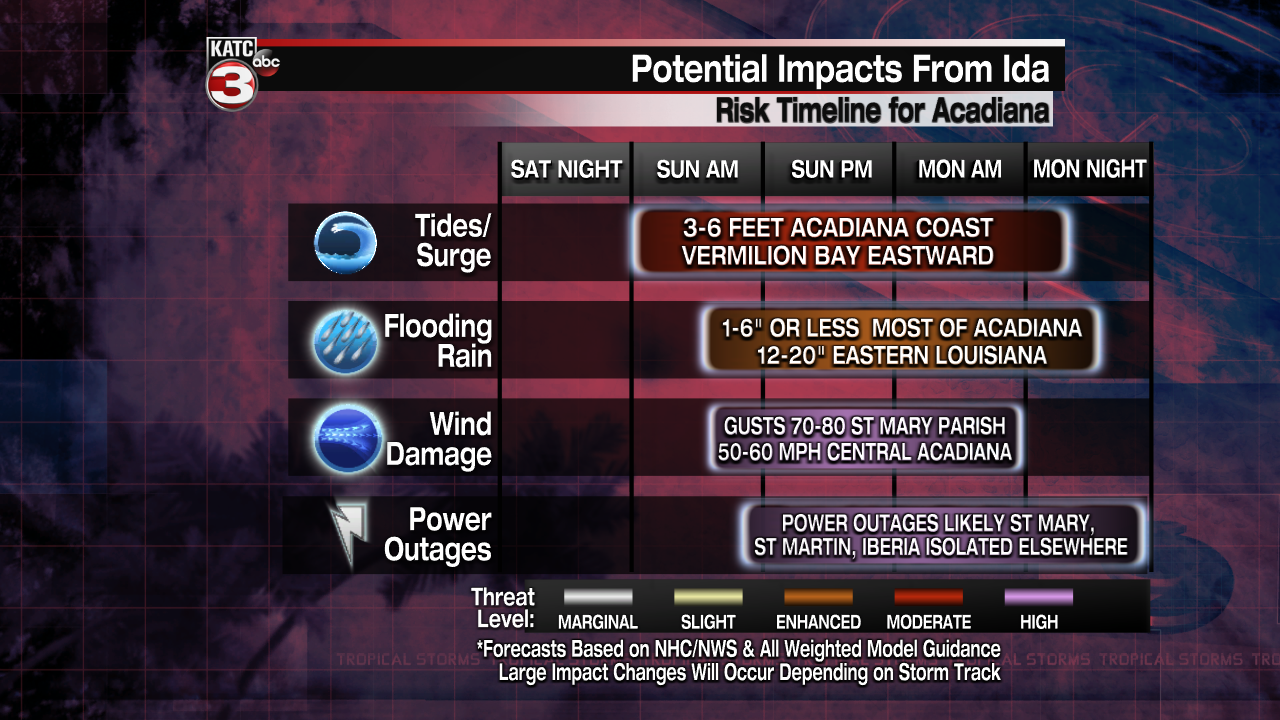
Most of Acadiana will deal with winds gusts in the 55-65 mph range, the exception to this will be St. Mary Parish where wind gusts of 70-80 mph will be possible, and again winds will quickly pick up the further east you go.

The most catastrophic wind will be reserved for Louisiana's eastern shore, close to the Grand Isle area with gusts in excess of 130 mph, however, those winds do start to ease up fairly quickly as it moves inland.
Unfortunately though you're still likely to see gusts capable of producing damage all the way into Mississippi, even if they are not as extreme as they will be down along the coastline.
Surge along the eastern shore will likely be catastrophic with a possible 10-15 foot storm surge expected from the mouth of the Mississippi to Morgan City which will be the hardest hit areas when it comes to surge.
Morgan City to Burns point on the west could see a 6-9 foot surge while the rest of Vermilion Bay is looking at surge of about 3-6 feet, in fact that may even be difficult to achieve as there will be strong winds from the north pushing water out of the bay.
If there is a surge on the Vermilion Bay coast it would likely be later in the day Sunday into Monday when the winds shift and will no longer be from the north.

We will continue to provide updates through the day and as conditions worsen we will being to provide non-stop coverage through the day.
KATC will be covering the effects and aftermath of Hurricane Ida.
As we prepare, KATC’s Hurricane Safety Guide will get you prepared for what you need to know before any tropical system makes landfall, during a storm and afterwards.
We will begin streaming Hurricane Ida coverage on all platforms as the storm on Sunday - TV, Streaming Apps, katc.com/live, KATC News App. Scroll down for REAL-TIME updates as they come in.
For the latest story on the storm from our TV3 Weather Team, click here.
Below you can find links to the latest on important information from state and local officials:
Evacuations
Closures
Sandbags
School closures
Shelters
Curfews
How to Get Help
Damage Reports
Road Conditions
This list will be updated and links added as information is gathered by our team.
With COVID-19 still being reported in the state, KATC will continue our update of daily numbers. They can be accessed here.
------------------------------------------------------------
Stay in touch with us anytime, anywhere.
To reach the newsroom or report a typo/correction, click HERE.
Sign up for newsletters emailed to your inbox. Select from these options: Breaking News, Evening News Headlines, Latest COVID-19 Headlines, Morning News Headlines, Special Offers
