


LATEST 4 PM OUTLOOK:
Tropical Storm Arthur has officially made landfall in Matagorda, southeastern Texas, and is expected to move further inland. However, it's experiencing significant shear, with most of the storm's activity located far from its center. According to the NHC, "Marine observations and data from the NOAA Hurricane Hunters show tropical-storm-force winds are still ongoing within this convection well to the east and southeast of the center."

Arthur is expected to weaken. It's important to note that the forecast path has shifted west due to the storm's center relocation. All threats related to Arthur remain valid for today and tonight.

___________
If you haven't heard, Tropical Storm Arthur has officially made its debut as the first named storm of the Atlantic Season.

With sustained winds now reaching 45 mph, Arthur is currently skirting along the Texas coastline and is expected to make landfall later today, likely impacting southeast Texas or southwest Louisiana.

While little to no strengthening is forecasted before landfall, coastal areas will feel the effects with tropical storm-force winds. Some inland regions might experience gusts of 40-45 mph. Tropical Storm Warnings remain in effect for our coastal parishes, and we're still on the lookout for coastal flooding and storm surge of up to 4 feet during high tide.

We do not anticipate a major wind event, but it will be breezy through early tomorrow. As Arthur moves closer, its circulation will weaken by this evening.
Expect rounds of showers and thunderstorms to develop this afternoon as Arthur approaches. These storms may produce heavy rainfall as the system tracks northeast. We should see Arthur clear out by Thursday morning.

The SPC has upgraded our eastern areas to a slight risk (2/5) for severe weather.
Key Hazards:
- Isolated Tornadoes: There's a chance for quick spin-up tornadoes, especially in the yellow (2/5) zone.
- Damaging Winds: Strong winds are also a concern.
While the marginal (1/5) risk is lower, we should still stay alert!

According to the SPC, "Tropical Storm Arthur will track northward and affect LA and southern MS tonight. A zone of strong southerly low-level winds to the east of the circulation will result in some concern for overnight and pre-dawn tornadoes across southeast LA into far southern MS."
The severe weather threat completely shifts east Friday and Saturday.


A Wind Advisory has been issued for Acadiana and Central Louisiana between now and tomorrow evening. While the strongest winds are staying offshore, our coastal areas will experience some of the windiest conditions as Tropical Storm Arthur approaches. Most of the inland gusts are around 20-30 mph.

Expect windy conditions well inland throughout the rest of today and into tomorrow. Secure any loose items outdoors!

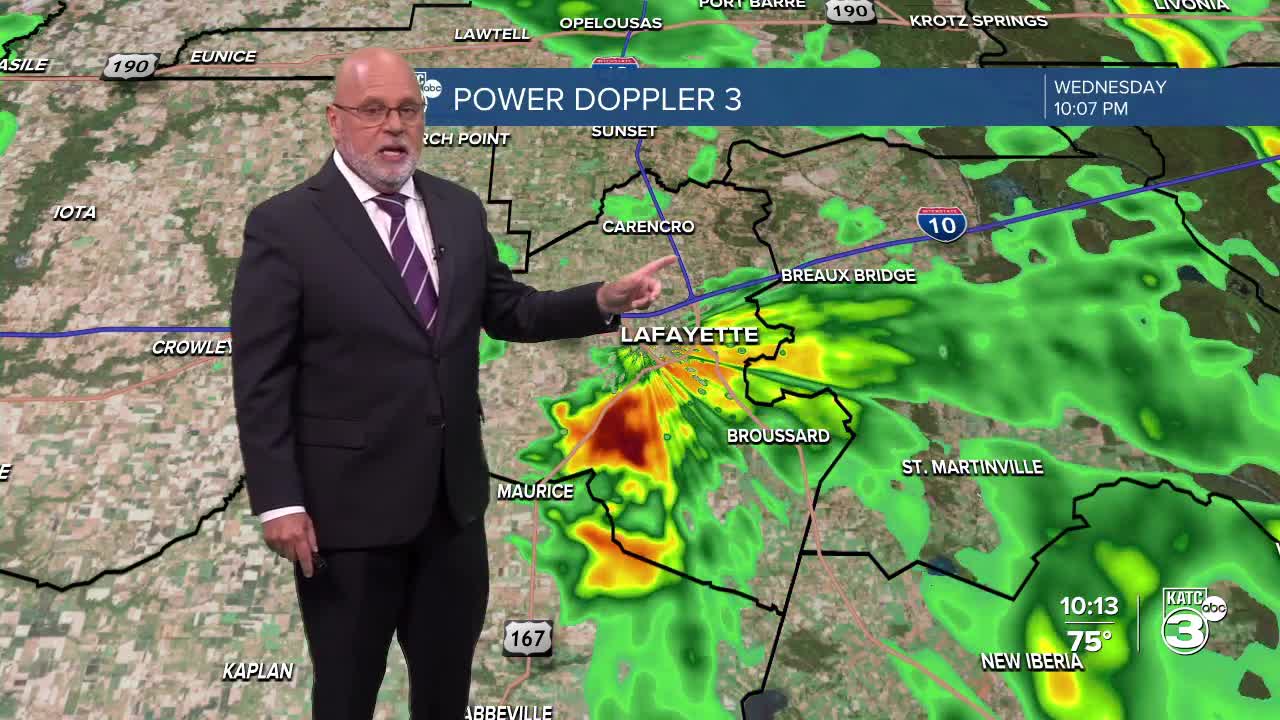
While most areas west of the Atchafalaya Basin are seeing less rain, expect heavier showers near Lafayette and to the east. That said, we’re still looking at scattered thunderstorms throughout Acadiana, with some pockets of heavy downpours possible.
A FLOOD WATCH is still in effect through tomorrow evening.

We could see rainfall totals of up to 5 inches, with some isolated areas experiencing even more. The HRRR model shows a decline in rain for areas west of Lafayette, but the GRAF model suggests ongoing precipitation in CENLA and Acadiana. I’m placing my bets on the GRAF. Radar updates will be provided!


Also, a COASTAL FLOOD WARNING is in effect until this evening for Vermilion, Iberia, and St. Mary Parishes, with water levels expected to rise by 2-4 feet. (I won't be surprised if this warning is extended.) Please be cautious, as numerous roads may be closed and low-lying areas may be inundated.
Looking ahead, the WPC has adjusted the moderate (3/4) risk for heavy rainfall further east, but we’ll still have an excessive rainfall outlook for tomorrow and Friday due to lingering scattered activity.


But there’s good news on the horizon! This weekend, just in time for Father’s Day, an upper-level ridge will start to build in, bringing back that classic summer pattern.
Follow Meteorologist Breyanna Lewis for further updates.
See the KATC 10 Day Forecast for the latest.
