


If you have been enamored with Acadiana's cloudy, spring-like weather pattern of late, you'll like the forecast into the weekend.
Like last night, expect clouds to eventually manifest into some foggy conditions as cloud decks lower toward daybreak.

A Dense Fog Advisory will be in effect for the I-10 Parishes southward to the coast from midnight through 9am Friday.
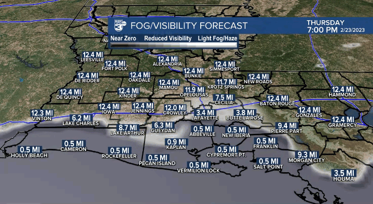
In general, visibilities will likely drop closer to 1/4-1/2 mile in most locations within the Fog Advisory area.
The closer to the coast the fog should be the thickest and the slowest to improve, if at all in the coastal waters, before the process repeats again into Saturday.
Temperatures at night will remain some 20° above normal given the time of year with lows near 70°.
After foggy and overcast skies in the morning, look for another mostly cloudy day with a few intervals of afternoon sun from time to time to help push our temperatures into the lower 80s (some 10-14° above normal).

A frontal boundary just to our north will begin to retreat into the weekend insuring the pattern changes little into this weekend.

We could see a little more in the way of afternoon sun for the weekend, especially Sunday afternoon.
Our next cool front will be on the tail end of the system, providing some lift for a few scattered showers Monday (at 30%), but we are not anticipated any big or widespread storms.
The aforementioned storm system Monday could bring a substantial severe weather threat to the "older" portions of tornado alley, primarily in and near Oklahoma Sunday into Monday.
Behind the front Monday, we'll see a little mid-week cooling, especially at night into the 50s for one or two nights, before warming back up toward Thursday.
At least we should see more sun for 3 to 4 of the days next week!
Another weather system, part of another big system later next week looks to bring storms to the region Thursday night into early Friday...and although too far out for any certainty, there may be a severe weather threat locally with the storms toward the end of next week.
Thereafter, with any luck, a nice and more seasonably cooler weekend will follow for the first weekend in March.
See the KATC 10 Day Forecast fort the latest.
------------------------------------------------------------
Stay in touch with us anytime, anywhere.
To reach the newsroom or report a typo/correction, click HERE.
Sign up for newsletters emailed to your inbox. Select from these options: Breaking News, Evening News Headlines, Latest COVID-19 Headlines, Morning News Headlines, Special Offers
