After such a nice day with sunshine and temperatures in the mid-upper 70s Wednesday, Acadiana's weather pattern will return to an unsettled, wet and occasionally stormy period starting Thursday afternoon and likely continuing through Saturday now.

In between, rain chances should be lower Friday as models have showing more agreement on when our wettest patterns will occur.
For now it appears that the highest rain chances for the area will be Thursday afternoon/evening and then again late Friday night or more likely now into Saturday.
We are still maintaining decent rain chances for Friday although activity should be lighter and more sporadic.

On the weather map, huge upper low dropping out of the Rockies Wednesday is expected to slow and stall in Texas Thursday into Friday.
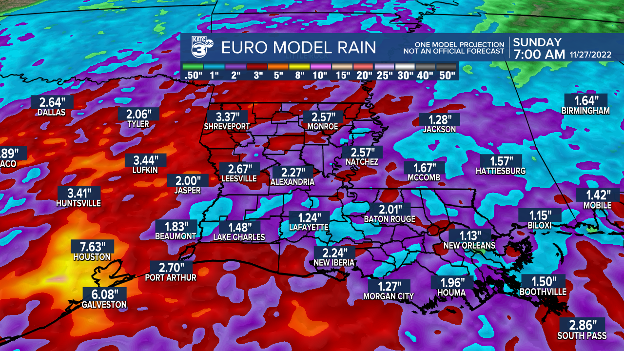
This should allow for at least two major waves of showers and storms to move across the Acadiana area with the threat of a couple of inches of rain through Friday then a few more likely into Saturday.

Because of this, the Weather Prediction Center (WPC) has Louisiana hatched in for a slight risk (level 2 out of 4) of excessive rainfall Thursday and again for Friday...with this threat likely to continue into Saturday.


In addition, the WPC is also calling for soaking rains of 2-4" for most of the Acadiana region with higher amounts of 3-5" or more likely back into Southeastern Texas.

And in addition to the threat of localized heavy rain amounts, the Storm Prediction Center has a good chunk of Southeast Texas into Southwest Louisiana hatched in for a marginal risk (level 1 out of 5) for a few isolated severe storms that could produce damaging winds and perhaps an isolated tornado.

The parishes in our area that are included in the marginal risk include portions of Jeff Davis, Allen, Beauregard, Calcasieu and Cameron parishes.
Whatever storms that do get going, even east of the marginal severe weather outlook area Thursday, could become strong at times.
Based on the latest model data late Wednesday afternoon, we'll be going with an 80% chance of rain and storms for Acadiana by late Thursday afternoon for most (sooner to the west), with the chances increasing to 90% Thursday evening/night.
Friday we've toned down the chances to 50-60%...but may have to go even lower.
The risk of showers and storms should then increase either late Friday night or more likely now Saturday, with another round of some potent storms and locally heavy rainfall.

Model data has also been consistent on rainfall with most if not all of Acadiana catching 1-3" between Thursday and Saturday with a number of areas seeing closer to 2-4".

And almost always, when we're forecasting a 2-4" rainfall there are usually a few isolated spots that see double the amount.
So the bottom line, beware of some street flooding when the storms are at their worst and most persistent.
Sunshine should finally return to the area Sunday.
As for temperatures, look for readings to hold in the milder 50s overnight through Thursday morning, rising into the low-mid 70s for our Turkey Day.
Temperatures should drop and stay in the low-mid 60s Thursday night into Friday and in all likelihood into Saturday.
Cooler conditions should move in in the wake of the mess Saturday night with lows approaching the upper 40s to lower 50s.
Sunshine with highs near 70° are expected Sunday and Monday.
Our next weather-maker will arrive mid-next week with another low end possibility of a severe weather threat but not heavy rainfall.
See the KATC 10 Day Forecast for the latest.
------------------------------------------------------------
Stay in touch with us anytime, anywhere.
To reach the newsroom or report a typo/correction, click HERE.
Sign up for newsletters emailed to your inbox. Select from these options: Breaking News, Evening News Headlines, Latest COVID-19 Headlines, Morning News Headlines, Special Offers


