


The winter-time sub-tropical jet stream and a stationary surface front spanning across the Gulf Coast states is expected to keep plenty of clouds, cooler temperatures and rain chances in the forecast much of the week.

The biggest soaking for this week will be shaping up for Thursday.
In the near-term, temperatures will gradually cool most areas overnight as a nearly stationary frontal boundary sags farther into the Gulf of Mexico.

This will keep low overcast skies with some drizzle/mist in the forecast locally with some fog most likely toward the coastal areas.

Temperatures overnight will drop into the upper 50s and that's where they should stay throughout the day tomorrow...some 10° cooler as compared to Monday for most.

More clouds and the possibility of brief, spotty rain showers (40%) will be possible Tuesday as a weak disturbance in the sub-tropical jet passes through the region.
Little change overall is expected Wednesday albeit with slightly lower rain chance (20%).
By Thursday, low pressure is expected to develop along the frontal boundary in the Gulf and get carried northeastward toward Acadiana by Thursday.
This will bring high rain chances (80-90%) back to the area late Wednesday night into Thursday.
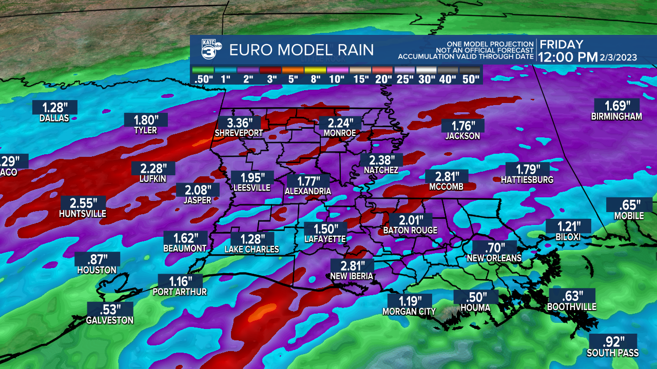
And yet again, Thursday's weather system should bring another soaking with up to a couple of inches of rain possible.
After Thursday, it looks likely Acadiana will finally get to dry out for a few days into the weekend.
And farther to the west where the air will be decidedly colder, there will be several periods of winter weather toward Central into Northeastern Texas where a significant ice and sleet storm may occur making for hazardous travel along with the possibility of some weather delays at DFW.

We won't see any of winter weather here.

Expect chilly January temperatures for much of the week with highs mostly in the 50s and lows in the 40s...and it will be colder in the wake of Thursday's weather system into
And while on the colder side, but at least both days this weekend should be dry.
The active pattern/jet stream won't rest for long with another rainy and possible severe weather-maker arriving to the region into mid-next week.
See the KATC 10 Day Forecast for the latest.
------------------------------------------------------------
Stay in touch with us anytime, anywhere.
To reach the newsroom or report a typo/correction, click HERE.
Sign up for newsletters emailed to your inbox. Select from these options: Breaking News, Evening News Headlines, Latest COVID-19 Headlines, Morning News Headlines, Special Offers
