A few isolated storms will remain possible through this evening.
Any storm activity will be moving in a north to south manner.
Bulk of the activity will come to an end after sunset, but certainly before midnight.
Stay cool and hydrated if you are heading out for some Friday night football action this evening as it will be a warm one.
Temperatures will start out in the middle 70s Saturday morning.
Mostly sunny to partly cloudy skies can be expected throughout the day as high temperatures settle into the middle 90s.
If you are planning to head to SE LA this weekend to help in the recovery efforts, be sure to take plenty of breaks and drink plenty of water.
Keep in mind most people down there will be without power and cooling off in the AC will likely not be an option.
A ridge of high pressure will be in place aloft this weekend helping to suppress widespread shower and thunderstorm activity.
With that said, we still can not totally rule out a couple isolated storms trying to develop with the heating of the day for our afternoons.
We'll hold rain chances in the 20% range for both Saturday and Sunday.
By Labor Day, a frontal trough to the north will be advancing southward, and depending on how far south it makes it will have an impact on whether our rain chances increase or decrease a bit.
I have split the difference for now and have a 40% chance for storms in place.
The mid-week forecast will be centered around 91L in the tropics.
The NHC gives it a low, 30% chance of development in the next five days.
Increasing wind shear across the Gulf of Mexico next week would likely keep any feature trying to develop on the weaker side.

Remember, storms like to be vertically stacked, but high wind shear acts to disrupt and tear them apart.
As a result, they are not really able to strengthen and get better organized.
Regardless of development, a surge of tropical moisture will likely increase rain chances for portions of the northern Gulf Coast by mid-week.
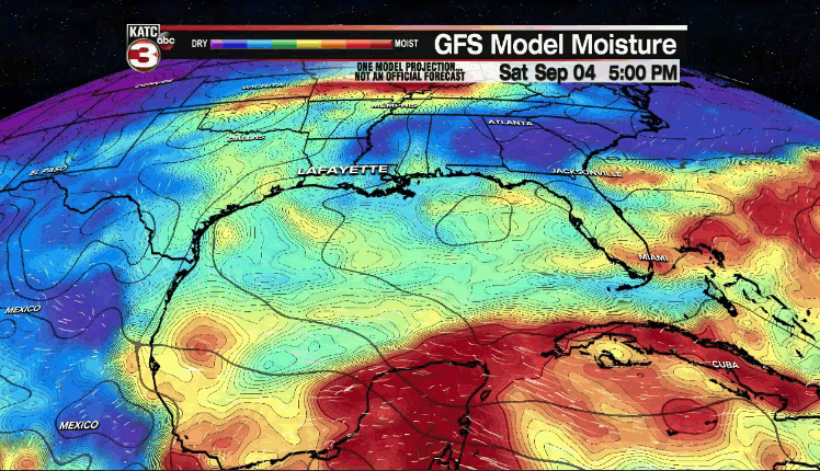
At least at this point, models continue to show the heaviest rain axis setting up just east of Acadiana.
Of course, any feature entering the Gulf this time of year bears watching and we'll continue to do so in the days ahead.
Beyond that, drier, slightly more comfortable air may try and work in by the end of next week.
We'll keep our fingers crossed that does indeed come to fruition!
Lastly, hurricane Larry will become the next major hurricane of the season.
It will track pretty close to Bermuda in the days ahead, but will likely miss the east coast of the US.
Rest of the tropics are quiet at this time.
Have a great weekend, y'all!
