


Acadiana's weather pattern will be on a roll into the weekend with plenty of sunshine accompanied by below normal temperatures and humidity, but enjoy it, as a wet and unsettled pattern will return and stay for most, if not all of next week.
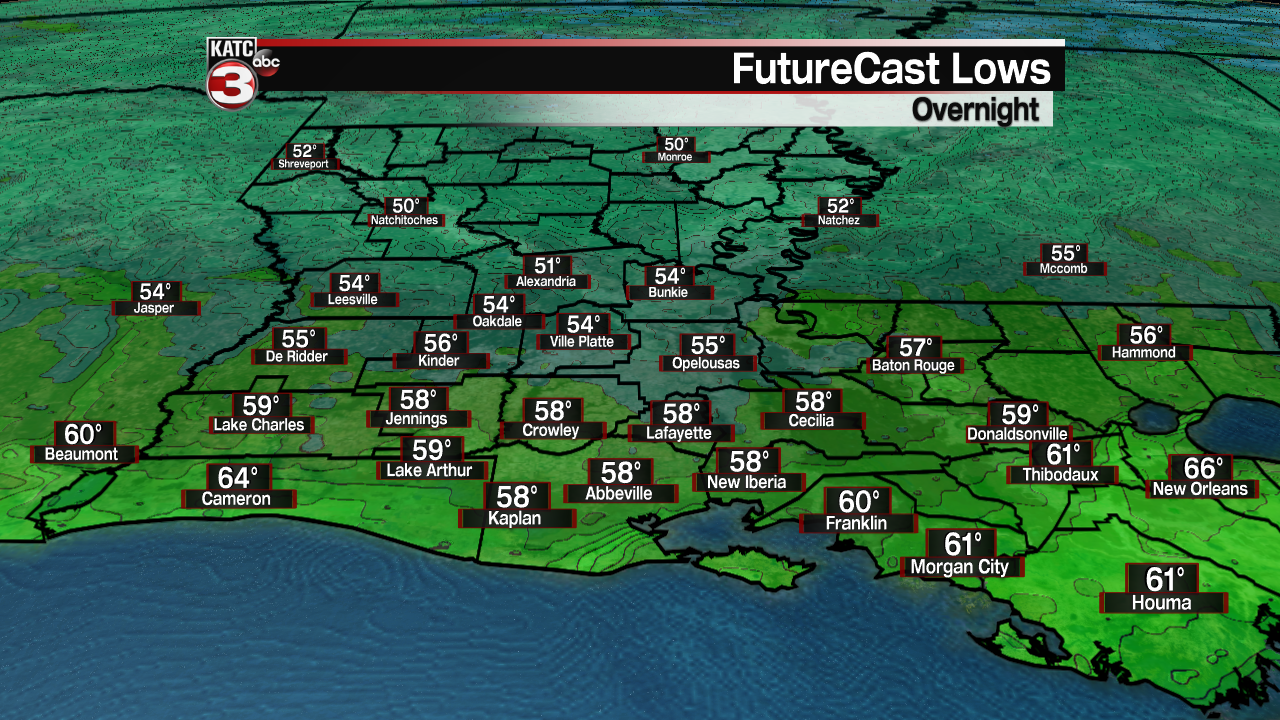
In the near term, most of Acadiana may see its last night in the 50s for perhaps the next 4 months or more, with lows ranging in the mid-upper 50s Friday morning...enjoy it while you can!
Friday and Saturday will be mostly sunny and pleasant with high temperatures reaching near 80° Friday and lower 80s Saturday.

Southerly to southeasterly winds will return Saturday night into Sunday ushering higher humidity and some clouds into Sunday afternoon.
Highs Sunday will be in the mid-80s.
It should stay dry for most of us Sunday with the low end possibility (20%) of a brief, isolated afternoon shower particularly toward Southwest Louisiana.
Deeper tropical moisture will advance into the region next week and with a series of upper disturbances rolling from west to east on nearly a daily and/or nightly basis next week, the result will be a good chance of showers and storms Monday through at least Thursday and/or Friday.

It remains too early to tell as to whether Acadiana may see additional flood threats, but with the wet pattern that has dominating so far this month and rather high water tables in the area, we could see more issues and perhaps the threat of a few strong storms from time to time as well.
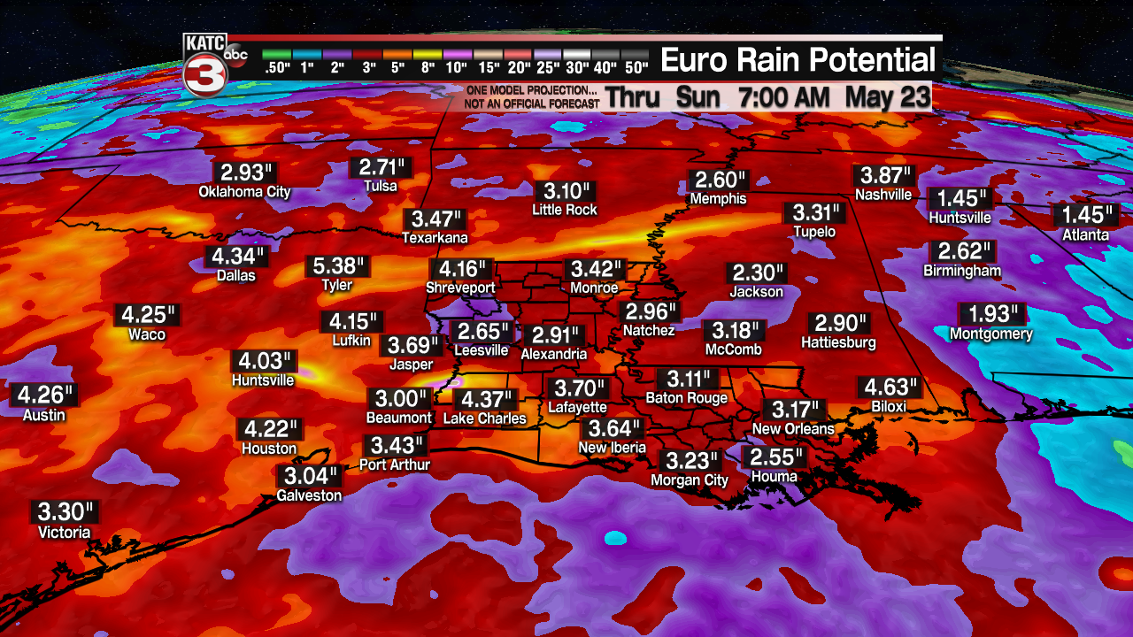
Models show rain totals beyond Sunday ranging anywhere from the 2-5" range for portions of Acadiana with the GFS concentrating the heaviest rains toward Texas and Oklahoma.
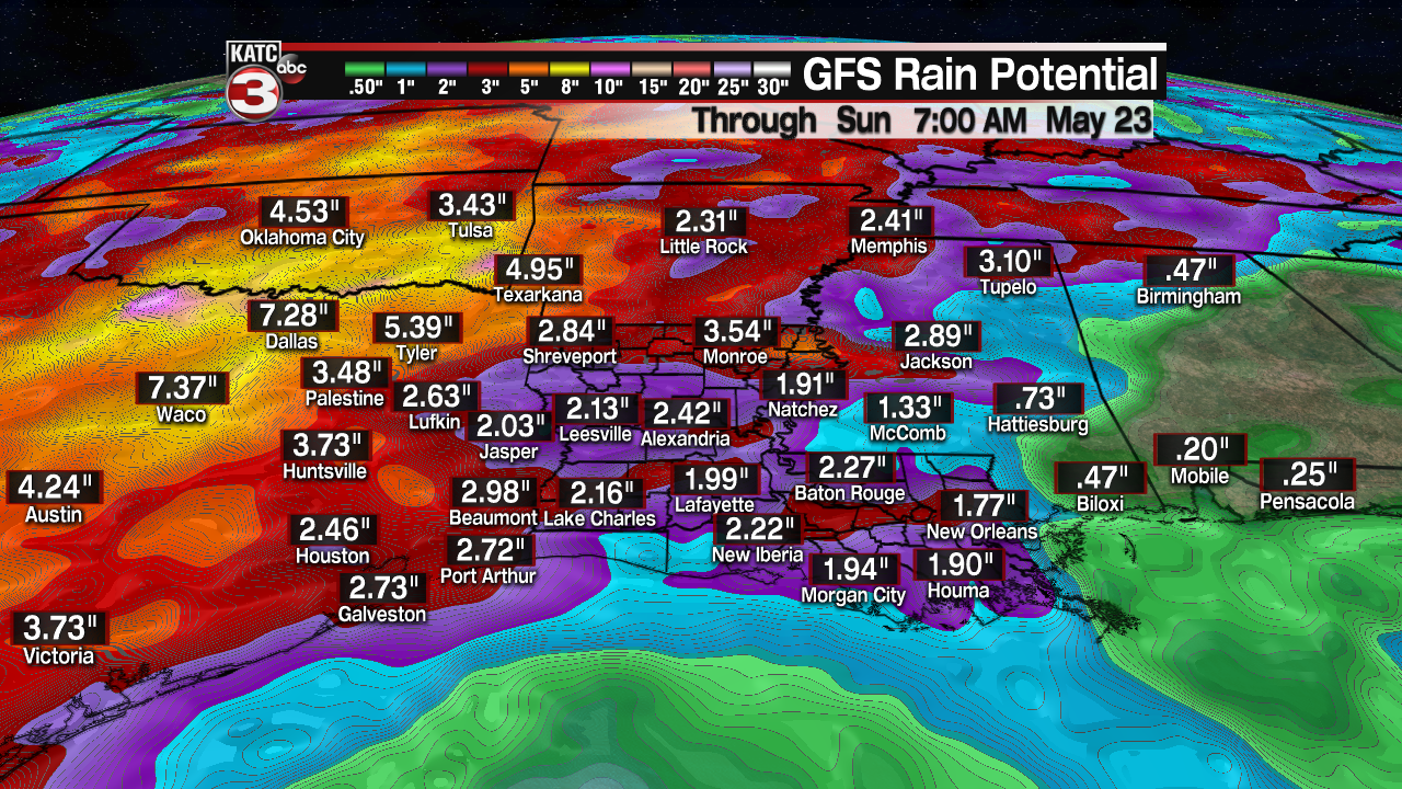
It should be noted that these are similar numbers that were forecast last week for our recent rains...and actual totals were more than double, and in some cases triple of the model guidance.
Hopefully our rain chances will tone down a bit for next weekend...but we certainly can forget about 50 degree temperatures for a while!
See the KATC 10 Day Forecast for the latest.
------------------------------------------------------------
Stay in touch with us anytime, anywhere.
To reach the newsroom or report a typo/correction, click HERE.
Sign up for newsletters emailed to your inbox. Select from these options: Breaking News, Evening News Headlines, Latest COVID-19 Headlines, Morning News Headlines, Special Offers
