


It will be a stormy start for Acadiana Friday with showers and thunderstorms likely, along with a low-end risk of a few severe storms and a couple of inches of rain possible.
An upper level trough combining with a relatively slow-moving cool front was producing showers and storms across Texas into Northwest Louisiana late Thursday afternoon.
This system will likely produce a mesoconvective complex (a cluster of widespread storms) that will be advancing southeastward toward Acadiana by daybreak Friday.

These storms will impact the Acadiana area primarily during the morning hours, with perhaps a midday/early afternoon break, followed by a "lesser" round of scattered storms into Friday evening.

Per the Storm Prediction Center (SPC), there will be a marginal risk of severe storms for Acadiana toward daybreak Friday.

A few storms Friday morning may contain strong, gusty, possibly damaging winds, perhaps some small hail, with a very low risk of an isolated tornado, but the risk is not zero.
After the round of widespread morning storms, Acadiana may see a midday/early afternoon break in the activity even with some sun possible, but a secondary area of scattered showers and a few storms will be possible into Friday evening.

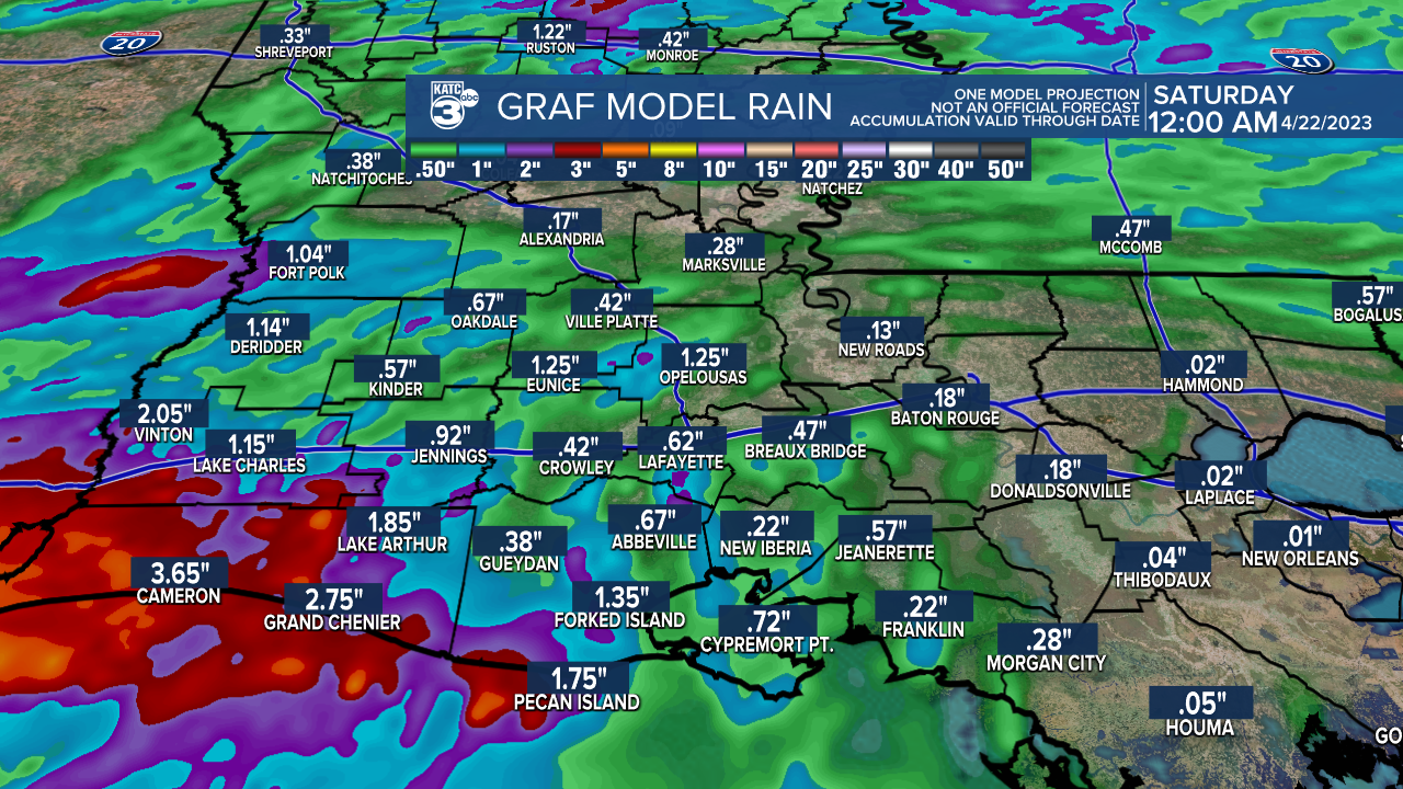
Rainfall totals should be 1-2" or less for most, but isolated hots spots near 3" or more might be possible, especially toward extreme Southwest Louisiana.
It should become drier and cooler after midnight Friday with sunshine returning for Saturday and partly cloudy skies expected Sunday.
Temperatures overnight through Friday morning will be in the mild, upper 60s to lower 70s, with highs Friday afternoon reaching the mid-upper 70s with the possibility of some partial midday sunshine.
After the risk of a few storms Friday evening, it should be cooler into Saturday morning with readings dropping into the mid-upper 50s.
Saturday will be a beauty with full sunshine, low humidity accompanied by temperatures rebounding into the upper 70s.
Sunday will be similar with a few more mid- and high level clouds in the region.
The pattern into next week becomes more unsettled with a good chance of showers and storms arriving Tuesday...thereafter, confidence is low on how the rest of the week will play out, with some decent rain chances perhaps again for Thursday.
The weather for the following weekend is looking favorable for biggest days of Festival International De Louisiane...fingers crossed!
See the KATC 10 Day Forecast for the latest.
Meanwhile, the pollen count was still kicking in the grass and tree categories across Acadiana Thursday, but Friday's rains will lower the numbers for a day or two.

Fortunately we're getting close to the end of this season!
------------------------------------------------------------
Stay in touch with us anytime, anywhere.
To reach the newsroom or report a typo/correction, click HERE.
Sign up for newsletters emailed to your inbox. Select from these options: Breaking News, Evening News Headlines, Latest COVID-19 Headlines, Morning News Headlines, Special Offers
