


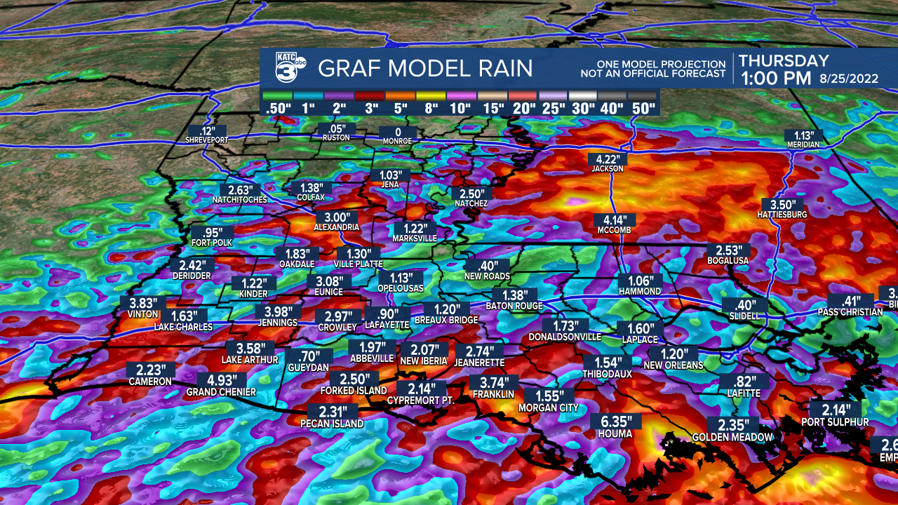
Acadiana's soggy weather pattern is expected to continue over the next several days with several more inches of rain likely for most areas through Friday.
A weak area of low pressure in the western part of Louisiana interacting with deep tropical moisture and disturbances aloft will continue to conspire to produce showers and storms across the area, with prime-time for activity from the pre-dawn hours through the afternoon.

And like the last several days, there will likely be several rounds of scattered storms for any one location Wednesday, Thursday and Friday.
Rain chances look to be in the 90% range Wednesday, near 80% Thursday and 70% Friday, while night-time chances will vary from 40-60%.
Generally in this type of pattern it's quietest on the radar from 9pm through 2am.
Rain totals looks to stay in the 1-2" range daily with isolated spots possibly receiving more leading to localized street flooding.
For now, a Flash Flood Watch continues for Central and Northern portions of Louisiana, but not Acadiana at this time.

Rain chances look to ease a bit this weekend with a little more sunshine possible, but the chance of daytime showers and storms won't be going away anytime soon with much of next week still offering above normal rain chances daily...see the KATC 10 Day Forecast.
Meanwhile in the tropics, there are a few areas of interest per the National Hurricane Center (NHC):
A wave coming off the African coast is given a 20% chance of development in the next 5 days, while the wave we have been tracking over the last couple of days in the mid-Atlantic looks to be weakening and is no longer expected to develop.
Closer to the Caribbean, a wave east of the Eastern Caribbean near the coast of South America was added by the NHC as a wave to track, and is given a 20% chance of development in the next 5 days.

The longer range deterministic models track this wave through the Caribbean perhaps heading toward the Gulf of Mexico in the 7-11 day time-frame.
Per the usual and so far for this year, the GFS is eager to develop a significant tropical system with potential Gulf of Mexico impacts, while the Euro remains more subdued, but does see some organization heading toward the Gulf at a slower pace than that offered by the GFS.
Either way, this appears to be the wave for our area to watch, but for now there are no overt threats to the region (other than the very wet pattern we're locked in) at least for the next week..stay tuned.
------------------------------------------------------------
Stay in touch with us anytime, anywhere.
To reach the newsroom or report a typo/correction, click HERE.
Sign up for newsletters emailed to your inbox. Select from these options: Breaking News, Evening News Headlines, Latest COVID-19 Headlines, Morning News Headlines, Special Offers
