Scattered showers and a few thunderstorms on tap for Acadiana Wednesday while Tropical Storm Karl has formed in the Bay of Campeche in the Southwestern Gulf of Mexico.
Karl will not be a threat to Louisiana or the U.S.
Meanwhile, some limited tropical moisture will advance into the region locally Wednesday while an upper disturbance rolls in from the west.
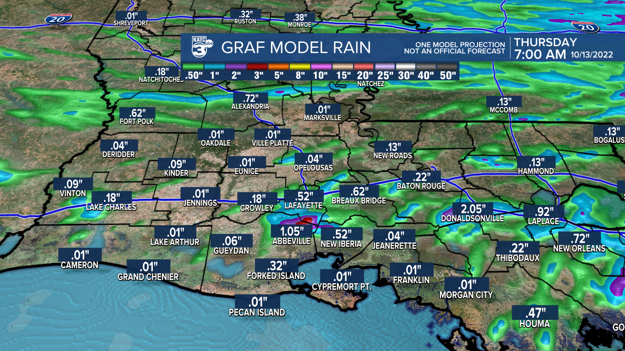
These features should combine to bring the best chance in more than a month of some scattered showers and a few thunderstorms for the area.

Don't expect much rain however, as activity is expected to remain scattered in nature during the afternoon, with another round of brief showers possible within a few hours of midnight prior to a weak front pushing through the area Thursday morning.
We could certainly use the rain, but don't expect much more than enough to settle a little dust, if that, with rainfall totals generally 1/4" or less.

There could be an isolated spot or two for the lucky few that may catch an inch.
Thereafter, its a return to sunny and breezy conditions Thursday before a little bit of a cool down by Friday morning.
Expect milder low temperatures over the next couple of nights to range in the upper 60s while afternoon highs should be in the mid-80s Wednesday and could push the upper 80s Thursday.

Readings should get back into the cooler 50s by Friday morning.
Friday and Saturday will bring more sun with seasonable temperatures while clouds increase Sunday along with the chance of a few showers Sunday afternoon.
The next good chance for rain should arrive Monday with a stronger fall cool front that should bring our daytime highs down to the upper 60s to lower 70s, while overnight lows dip into the "gumbo range" of the mid-40s for a couple of days mid-late next week.
See the KATC 10 Day Forecast for the latest.
Meanwhile in the tropics, a disturbance (remnant moisture from the former Hurricane Julia) became better organized throughout the day Tuesday in the Bay of Campeche garnering an upgrade to tropical storm status by the National Hurricane Center Thursday afternoon.

Tropical Storm Karl with 40 mph wind is expected to remain bottled-up in the Southwestern Gulf of Mexico over the next few days while having limited intensification potential and will be of no threat to the U.S. or Louisiana.
The system looks to be primarily a rain-maker for the state of Veracruz in Mexico over the next few days.
Climatology dictates that it is not unusual to have a meandering tropical system (sometime for days) in the Southwestern Gulf of Mexico during the month October.
------------------------------------------------------------
Stay in touch with us anytime, anywhere.
To reach the newsroom or report a typo/correction, click HERE.
Sign up for newsletters emailed to your inbox. Select from these options: Breaking News, Evening News Headlines, Latest COVID-19 Headlines, Morning News Headlines, Special Offers


