Well after last week's winter storm and frigid temperatures, it would make sense that most of us are probably dreaming of 70 degree temperatures and days filled with sunshine (Sort of like what we saw on Monday and Tuesday).
For others, it may be the smell of freshly cut grass and the sound of a crack of a bat at a baseball game. Alas, it's the sights and sounds of SPRING.
The arrival of spring also marks the beginning of peak severe weather season. Side note: We technically have a secondary severe weather season here in the southeast during the fall ~ November-December.
And while severe weather can strike in South Louisiana at any point during the year, spring is the time when the atmosphere is most primed to support it.
It's when we often see the clash of two air masses: Warm, moist unstable air from the Gulf of Mexico that interacts with colder air that still tries to push southward (Remember it is not summer quite yet, so cold fronts can still technically push through).
So with that moisture gradient in place, and granted we have other ingredients/dynamics to work with as well, we can get severe thunderstorms to develop.
The dynamics and specifics on how we get different types of severe weather are unimportant for this discussion, but we will try and use explanations as best as we could as certain situations present themselves.
So, let's get into it.
First off, the National Weather Service (NWS) states that for a thunderstorm to achieve severe status, it must produce either a tornado, damaging wind gusts in excess of 58 mph, or large hail that is at least 1" in diameter or larger.
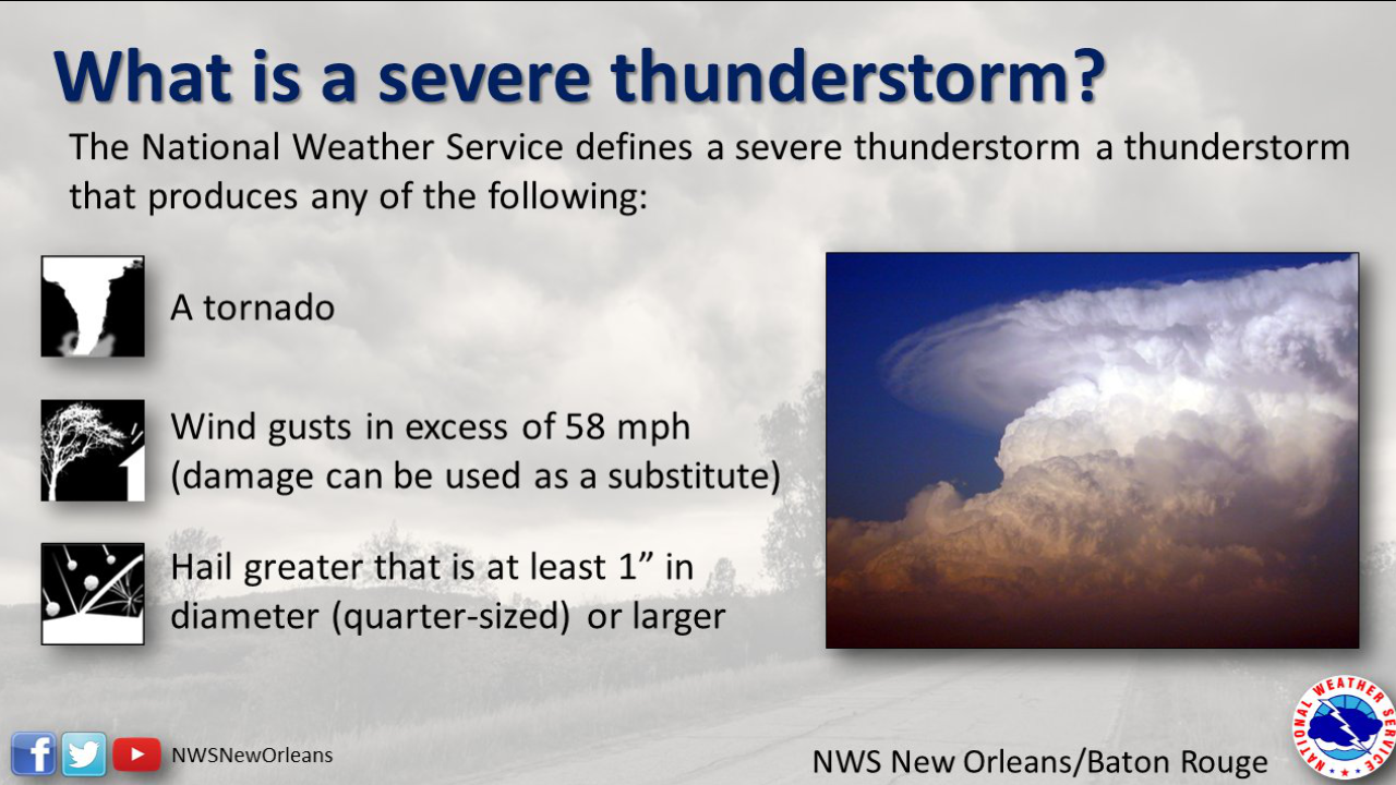
The first would obviously prompt a tornado warning while the other two would require the weather service to issue a severe thunderstorm warning for the area they cover.
Now the question is: Would you know what a warning meant if issued for your area? What about a watch? You may be asking what is the difference between the two?
These are the questions we actually get quite often in the weather lab. Being able to distinguish between the two can be life saving in the spur of the moment.
Let's start off with a watch.
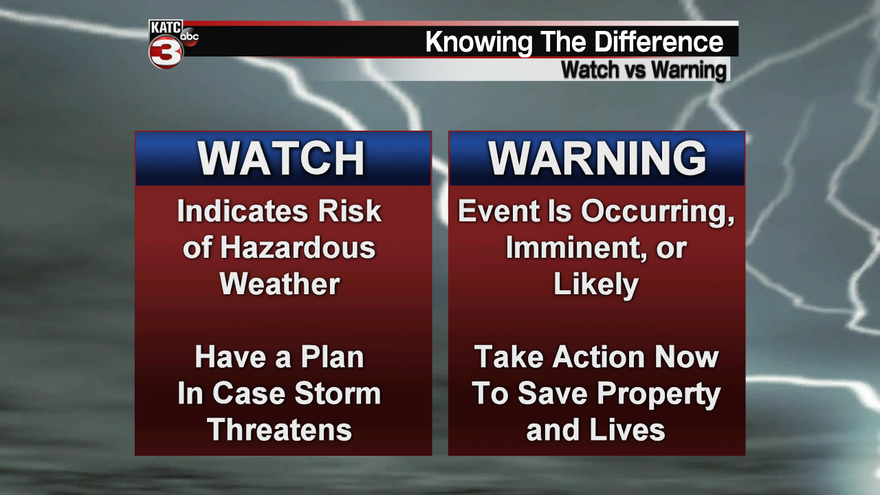
You probably have heard us use phrases like "A tornado (or severe thunderstorm) watch has been issued for the area."
This means that atmospheric conditions are conducive for severe weather development BUT severe weather is not currently ongoing.
Watches usually cover around a 6 hour time period (give or take a couple of hours) in advance of any severe weather that may develop.
It simply means to stay alert, keep an eye to the sky, and know that severe weather is possible for the "watched" area.
This is when you want to make sure to have your NOAA Weather Radio All Hazards near by and ready to go and tune in to your local meteorologists for updates.
Every home and business is encouraged to have a NOAA weather radio in it. Here is a link with more info: https://www.weather.gov/bgm/nwrmain
In contrast, a Warning means that severe weather is actually
occurring/ongoing.
This is typically for a smaller, localized area within the larger watch area.
This is the time to take immediate action.
You want to be inside a sturdy structure away from windows.
You do NOT want to be sightseeing outside to get a better look or anything like that.
And specifically for tornadoes, especially here in Louisiana, they can be rain wrapped and hard to spot regardless.
In many cases, they are not going to be your classic tornadoes that you see in the plains, so keep that in mind.
Furthermore, damaging winds can also present danger (flying debris, damage to structures, etc.) and severe hail can cause damage as well.
Bottom line: Inside is the place to be.
Additionally, you want to be in your safe space when a tornado warning is issued.
A tornado basement (or any sort of basement for that matter) would be the most ideal; however, most homes down here lack a true basement.
So, we turn to our next best option.
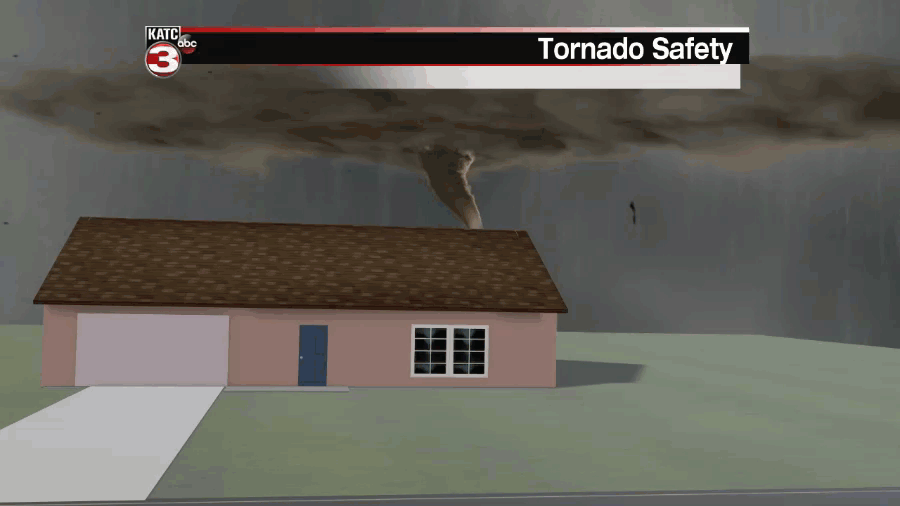
You want to be on the lowest level and in the center of the building/home you're in (Away from windows of course). A closet or bathroom is considered a good place.
If you have a helmet nearby and readily available, go ahead and through it on to protect yourself from potentially flying objects/debris.
Otherwise, use something like a mattress for protection.
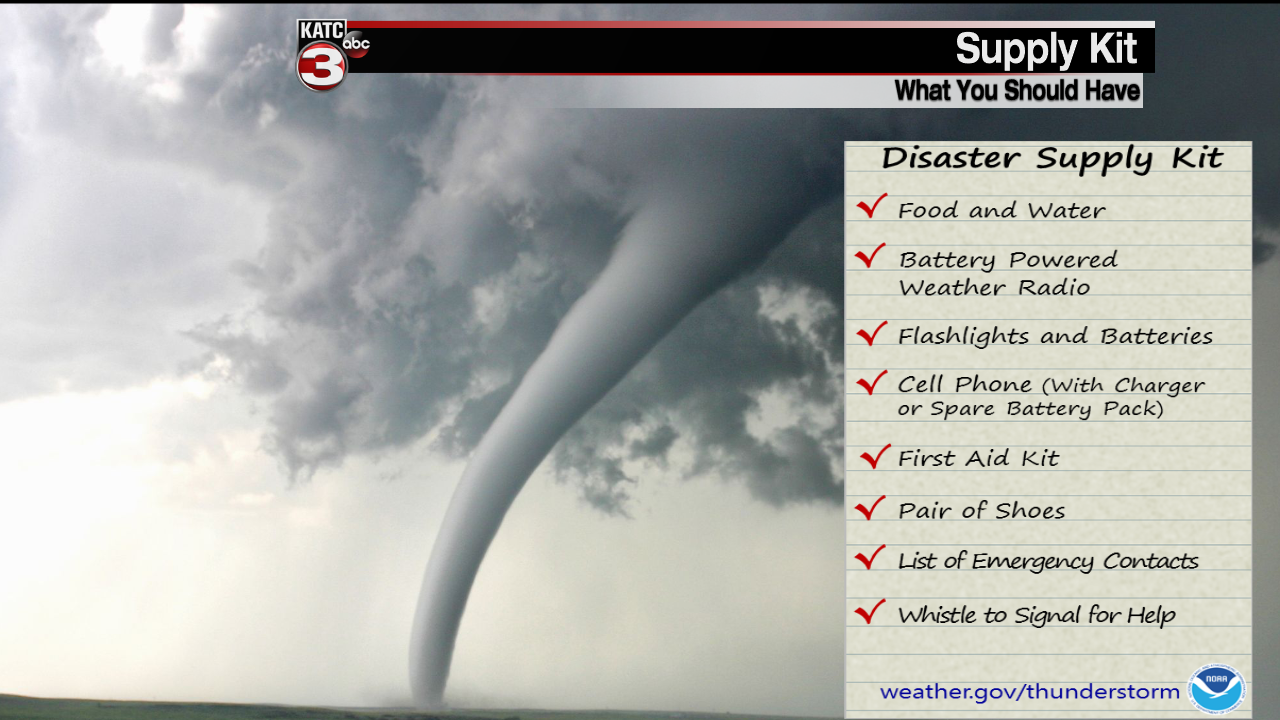
Here is a list of supplies you want to have handy in the event severe weather strikes:
Of course, whether it's severe weather, hurricane season, or a winter storm, the KATC storm team is here to get you, your family and property through it all.
~ Bradley
