


The never-ending record smashing heat wave of 2023 is expected to continue through the weekend and into Monday, before there may be a little change in Acadiana's overall weather pattern.
Strong high pressure centered over the nation's mid-section will continue to dominate our weather allowing for few, if any showers or thundershowers Thursday (10%), along with highs temperatures once again reaching near 105-106°.

Although unofficial at press time, Lafayette reached at least 105° this afternoon matching the all-time record high set for August just last Sunday. This is the 3rd hottest temperature ever recorded in Lafayette over the last 130 years.
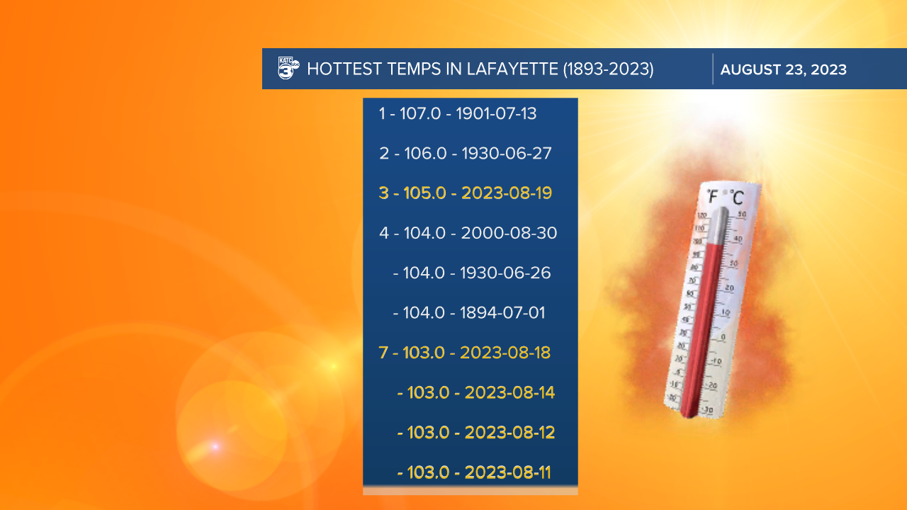
The hottest temperature ever recorded in Lafayette was 107° set on July 13, 1901...106° was reported once on June 27, 1930, in the Dust Bowl years.

The forecast Friday through Monday will keep our highs in the 103-106° range, and any one of those days, like today/Wednesday, we may see a high temperature a degree or two higher than forecast.
Finally, there seems to be a little relief on the horizon as a frontal trough approaches the area Tuesday...this could spark off a round of storms, and then usher in slightly cooler, but still relatively hot temperatures mid-late next week.
Behind the frontal trough, highs should be closer to 98-101° later next week while more importantly, lows drop closer to the low-mid 70s...hey we'll take what we can get these days.
See the KATC 10 Day Forecast for the latest.
Meanwhile, if you have been seeing and smelling smoke today, smoke from a wildfire in Beauregard Parish has been spreading through portions of Acadiana with light N/NW winds this afternoon...most of us will likely see it and smell it overnight through Thursday morning.

The fire danger will remain high locally through the weekend, and perhaps into next week as well.
As for the tropics, while there are a few spots the National Hurricane Center is watching, the main player remains Tropical Storm Franklin which will pull away from Hispaniola and move into the open Atlantic where it is expected to become a Category 2 hurricane in 4-5 days.

While Franklin is not expected to be a threat to the U.S. at this point, it will likely garner some East Coast concerns (perhaps waves, rip tides and beach erosion at the last) perhaps down the road.
In other tropical news, the European Model has been hinting that moisture pooling near Central America will advance northward toward the Yucatan Peninsula later this weekend or early next week with some potential Gulf development possible thereafter.

With the aforementioned trough moving into the region by Tuesday, any developing system would likely head for the Eastern Gulf of Mexico and Florida next week.
So our drought here in Acadiana is only expected to worsen over the next couple of weeks...we'll have a drought update coming from NOAA Thursday.
------------------------------------------------------------
Stay in touch with us anytime, anywhere.
To reach the newsroom or report a typo/correction, click HERE.
Sign up for newsletters emailed to your inbox. Select from these options: Breaking News, Evening News Headlines, Latest COVID-19 Headlines, Morning News Headlines, Special Offers
