


Odds of tropical depression formation in Gulf of Mexico this week continues to slowly grow while the threat of flooding rainfall for Acadiana also appears to be increasing into the weekend.
An area of disturbed weather in the Bay of Campeche/extreme Southwest Gulf of Mexico appeared to be getting organized Tuesday afternoon as a westward moving tropical wave appeared to be adding more fuel to the potential fire.

The National Hurricane Center (NHC) consequently and with better model agreement upped the odds of tropical depression formation later this week to 80%.
Current forecast thinking is that the disturbance will slowly get more organized through Wednesday with a northward drift toward the Northern Gulf Coast initiating shortly thereafter.
The European and GFS models were in rather remarkable agreement Tuesday that a tropical system, possibly approaching tropical storm strength by Friday, will advance northward toward the Upper Texas Coast/Southwest Louisiana Friday night into Saturday with the bulk of the attendant heavy rain threat likely to accompany the system especially to its north and east.

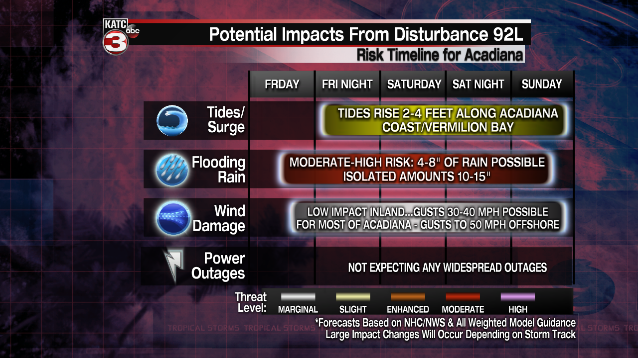
Whether a weak low, depression or even a tropical storm forms, by far the greatest threat to Acadiana with this system will be for the potential of heavy, flooding rainfall.
After shifting to the east overnight, today's models have trended to bring the heavier rains back to the west, and impacting Acadiana directly.
Of course a lot can change, especially since we likely will not be tracking a definitive area of low pressure possibly until Thursday, but rainfall for Acadiana Friday through Sunday could approach the 4-8" range.

And as with any tropical system, there will be the potential for isolated amounts up to 10-15" depending on where the heaviest rain bands set up and how quickly or slowly the system moves.

What remains concerning is the the GFS model is slower moving the system through Louisiana once it is inland Saturday which could to lead much higher rain totals.
Remember, in a tropical system, it's generally not how much rain, but how quickly it accumulates...and with any tropical-borne system, rainfall rates can easily top 2-3" per hour...and some spots may those rates for hours at some point.
At this juncture, wind nor power outages may not present any major issues for our area, but that could change depending on the intensity of the system at, and following landfall.
Tides along the coast however will likely rise late Friday and stay elevated through the weekend.
Below is the preliminary impacts for Acadiana...but this graphic will change with time:
The heaviest of rains are expected to arrive to our area by Friday afternoon/evening/night, last most of the day Saturday with the possibility of lingering heavy rains continuing into Saturday night and Sunday based on the GFS model in particular.
A resumptions of more typical summer weather is anticipated into next week, while in the short term fewer showers and storms are expected for the Acadiana area Wednesday and Thursday.
See the KATC 10 Day Forecast for the latest.
------------------------------------------------------------
Stay in touch with us anytime, anywhere.
To reach the newsroom or report a typo/correction, click HERE.
Sign up for newsletters emailed to your inbox. Select from these options: Breaking News, Evening News Headlines, Latest COVID-19 Headlines, Morning News Headlines, Special Offers
