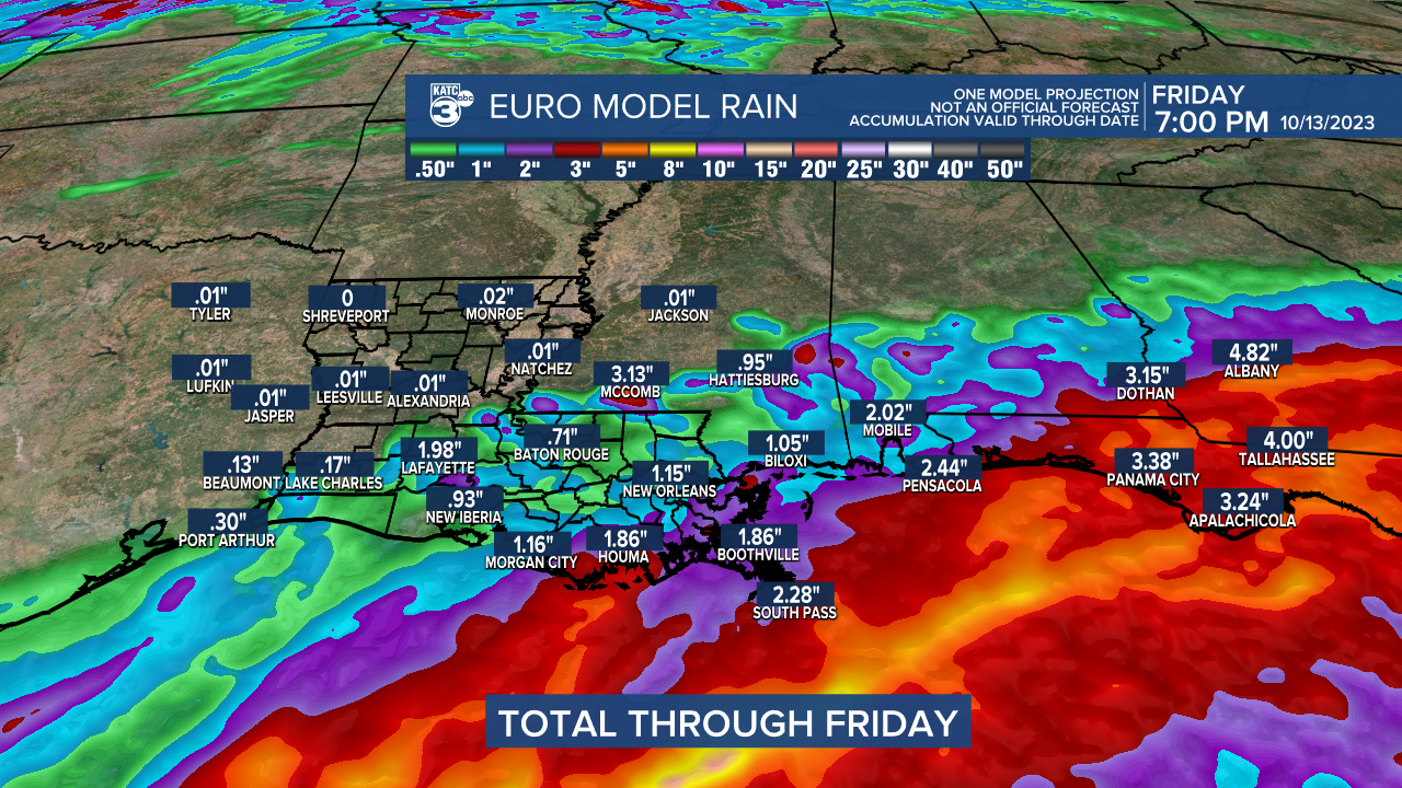
It will be one of the more interesting weeks shaping up for Louisiana and the Gulf of Mexico as rains for Acadiana are expected to develop with a weak area of low pressure that will traverse the Gulf from the southwest to the northeast mid-week.
This system will get a supply of residual tropical moisture from two land-falling tropical storms in the Eastern Pacific in Mexico.

While odds of a purely tropical system developing in the Gulf will be low, an area of low pressure should develop throwing a shield of rains toward Louisiana Wednesday with the possibility of an inch or two of much needed rain for the area.

Highest rain chances Wednesday will be across the coastal parishes into Southeast Louisiana where there could be a big soaking.

The risk of flooding rainfall should be east of most of Louisiana and Acadiana, with periods of rain beginning as early as Tuesday night and perhaps not ending until early Thursday.

The models continue to offer some varied solutions, with the Weather Prediction Center also highlighting the possibility of 1-2" of rain Wednesday.

With that being said, models might underestimate the rain totals for our area, but we do need the soaking and the risk of flooding should be low for the area, with the main emphasis of heavy rainfall spanning from extreme Southeast Louisiana into Mississippi, Alabama, Florida and eventually Georgia.
Rains should taper Thursday before our next front arrives Friday accompanied by the chance of scattered showers and a few storms.
Thereafter, it should be smooth sailing and a return of refreshing fall temperatures this weekend into much of next week.
In the near term, look for fair skies for Acadiana overnight into Tuesday morning with lows ranging from near 60° in Lafayette to mostly the 50s elsewhere and especially to the north.
Tuesday may bring some limited sun early before high clouds take over and thicken as the day wears on.
Highs Tuesday will be in the low-mid 80s depending on the thickness of the cloud cover.
Readings will likely hold in the 60s Tuesday night and perhaps most of Wednesday with a rain day on tap.
See the latest KATC 10 Day Forecast for Acadiana.
Meanwhile offshore, A Gale Watch has been posted for the offshore Louisiana waters Wednesday in anticipation of 30-35 knot winds with gusts possibly nearing 40 knots.

Annular Solar Eclipse Notes for Acadiana: The weather should be perfect for viewing the solar eclipse in Acadiana Saturday.

The maximum coverage of the sun will be 82% roughly at 12:02 pm...again NEVER look directly at the sun and use approved eclipse viewing glasses.

The lighting across Acadiana's skies will be akin to the "golden hours" of early mornings and late afternoons for roughly 30-45 minutes midday Saturday!
------------------------------------------------------------
Stay in touch with us anytime, anywhere.
To reach the newsroom or report a typo/correction, click HERE.
Sign up for newsletters emailed to your inbox. Select from these options: Breaking News, Evening News Headlines, Latest COVID-19 Headlines, Morning News Headlines, Special Offers


