


A Hard Freeze Warning is in effect for most of Acadiana through Tuesday morning as temperatures are expected to drop well below freezing, into the mid-20s, not including the wind chill.
Low temperatures will be highly dependent on the amount and thickness of high clouds (that can act as a blanket) and the surface wind...more wind generally does not allow maximized cooling.
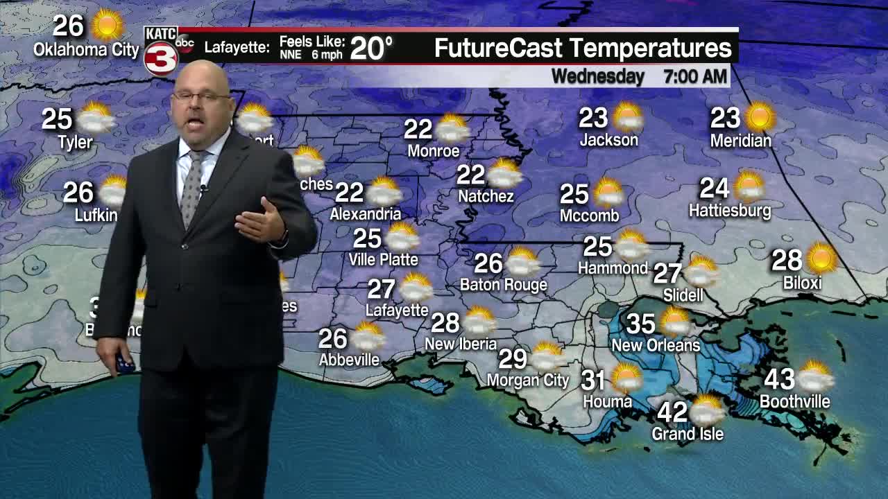
But the bottom line, expect temperatures to drop below freezing with readings ranging from the low-mid 20s across the northern Acadiana parishes into Central Louisiana, the mid-20s along the I-10 corridor, and mid-upper 20s to near 30 along the coast where there is more warming marsh water and where high clouds should be the thickest.
Temperatures will stay below freezing anywhere from 10-14 hours across the northern parishes I-10 and northward and closer to 5-10 hours along the coastal parishes.
Pipe precautions are recommended, especially for the northern most portions of Acadiana, including Allen, Evangeline, St Landry and Avoyelles parishes where hard freezing temperatures will be most likely for the most extended time.
And please follow the safety tips below when using space heaters:
With mostly sunny skies early tomorrow, temperatures should climb above freezing by 10 am and rise to near 50 degrees during the afternoon.
Acadiana should stay well above freezing Wednesday night into Thursday morning as clouds thicken and period of light rain develop into Thursday as a quick-moving upper level disturbance produces weak low pressure troughing in the Gulf of Mexico.
And don't be too surprised when the light rain begins to develop Thursday night that there might be a few sleet pellets mixed in at the onset, but northing of significance will stick as it will be way too warm.
And it will be chilly rains Thursday with temperatures holding in the mid to upper 40s.
Skies will clear Friday and look for mostly sunny conditions, but well below normal temperatures will very likely continue through Sunday.
Daytime highs Friday into the weekend will be in the mid to upper 50s while overnight/morning lows will be in the potentially "frosty-zone" of low to mid 30s.
Milder temperatures, with readings getting back to near normal, are expected into next week per our 10 Day Forecast.
Climate notes: An "old school" rule of thumb in forecasting is to never forecast a record...but with guidance coming in colder than the 26 degrees I'm forecasting for Lafayette tomorrow morning, which would beat the record of 27 set back in 1911...
And more interesting, we have hit 26 degrees only once earlier in November (records going back to 1893), on the 3rd in 1966...
So if we happen to drop to 25 it will be the coldest temperature recorded so early in the season!
Key issues on maximizing our lows tonight will be amount of high cloud cover and whether the winds die down enough to maximize the effects of radiational cooling.
Anyway you slice it, pretty cold for this time of year!
