


After a couple of more mostly sunny, hot, increasingly breezy and humid days to finish the week, Acadiana will see a change in the pattern with a good chance of showers and thunderstorms developing this weekend.
In the near term, look for fair, warm and a little more humid conditions for the area overnight through Thursday morning with lows in the lower 70s.
Thursday will bring more of the same weather of late, with some morning clouds giving way to mostly sunny and hot conditions into the afternoon.

Look for highs Thursday to reach the lower 90s, but we'll have breezier winds in the afternoon to take the edge of the heat but will add to our humidity.
Rain chances will stay near zero again Thursday.
Friday will bring much the same, only breezier and more gusty (25mph+) into Friday afternoon.
This weekend we'll see the upper ridge that has been dominating our weather of late to break down opening the door for disturbances aloft producing more atmospheric instability.
At the same time, deeper tropical moisture will be infiltrating the Gulf of Mexico reaching Louisiana by late Saturday.

Thus, a good chance of showers and storms will enter the forecast this weekend with activity mostly likely later Saturday afternoon but occurring at anytime on Sunday.
Daily rain chances look to stay elevated at least through early next week, despite our first wave of some African dust this year working into the region by Monday.

It remains unclear as to whether the dust could mitigate some of our rain chances early next week or just make for rather hazy skies before the daily storms fire up.

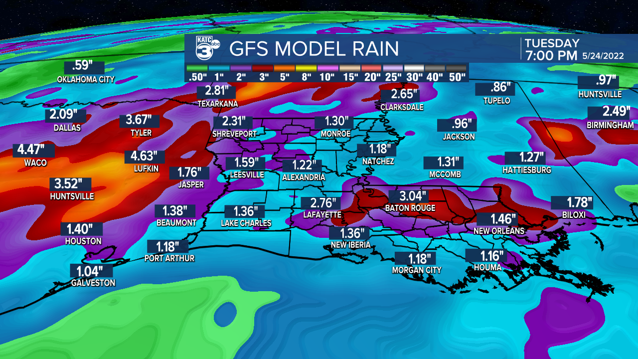
The bottom line: we should see a pretty good soaking across the region from Saturday through at least next Tuesday with both the GFS and the Euro indicating a few inches of rain minimally...and we all know that when storms are active here rain totals can push double the model estimates.
At least with better rain chances in the forecast it won't be as hot into the first part of next week with daily highs easing closer to the low-mid 80s.
The daily chance of scattered showers and storms should last but perhaps slowly ease next week with the pattern looking hotter and drier again toward Memorial Weekend.
See the KATC 10 Day Forecast for the latest.
Meanwhile in the tropics and not surprisingly, the GFS model has jumped off of any significant tropical development in the Northwest Caribbean/Gulf of Mexico.

While heavy and potentially flooding rains will develop near Central America over this weekend and several days beyond, any organized system is not expected to work into the Gulf at this time, with Eastern Pacific development a more likely possibility into next week.
Meanwhile, Louisiana is still on track for some of this moisture to work its way through the Gulf and should begin to help feed our storms/rain chances in Acadiana and Southern Louisiana this weekend.
------------------------------------------------------------
Stay in touch with us anytime, anywhere.
To reach the newsroom or report a typo/correction, click HERE.
Sign up for newsletters emailed to your inbox. Select from these options: Breaking News, Evening News Headlines, Latest COVID-19 Headlines, Morning News Headlines, Special Offers
