


After another breezy and warm day Thursday, a good chance of showers and locally heavy thunderstorms are in the cards for Acadiana Friday.
In the near term, southeasterly winds will make for milder temperatures overnight through Thursday morning with lows in the low-mid 60s under generally fair skies.
Look for a sun and cloud mix, with breezy and warm conditions for our Thursday with highs reaching the mid-80s.
Breezy southeasterly winds will turn more southerly Thursday afternoon with gusts approaching the 25-28 mph range.
Rain chances will stay low (near 10%) Thursday, but that will change toward Friday morning.
A slow moving frontal trough will advance toward Acadiana by Friday morning with an excellent chance (90% or better) of showers and storms starting in the morning.

We could get a break in the action into Friday afternoon, with another round of perhaps less intense showers and storms into early Friday evening.

The Storm Prediction Center (SPC) has a risk of severe storms mostly west of the area through late Thursday night, but edges a slight risk (level 2 out of 5) into Western Louisiana Friday.

Meanwhile, it appears that storms will be less intense as they cross Southern Louisiana Friday, with most of Acadiana hatched in for a level 1 out of 5, marginal risk.
We'll be on the look out for perhaps a few severe isolated storms that could be capable of damaging winds, perhaps some hail and/or an isolated tornado.
And while the storms might below severe levels, we'll still see plenty of lightning and locally torrential downpours.
Acadiana is hatched in by the Weather Prediction Center for a "slight risk", a level 2 out of 4, for excessive rainfall Friday, with at least 1-2" possible.
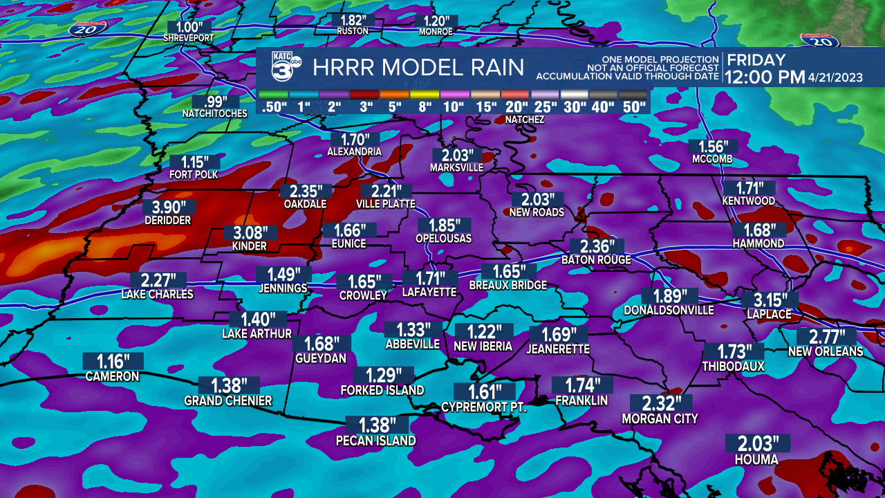
Isolated spots could catch more which could lead to some localized street flooding.
While most of the storms look to arrive and move out Friday morning, models are suggesting that perhaps another round of less intense activity could arrive toward Friday evening.
At least, the weekend is looking good and drier with sunshine Saturday and some clouds Sunday.
Rain chances could ramp again for mid-next week with the weather improving toward the big Festival International (FIL) Weekend!
There might be the threat of some showers though Wednesday and Thursday evenings, but Friday through Sunday tentatively look good!
Of course the FIL forecast might change 7-10 days out, but see the KATC 10 Day Forecast for the latest.
------------------------------------------------------------
Stay in touch with us anytime, anywhere.
To reach the newsroom or report a typo/correction, click HERE.
Sign up for newsletters emailed to your inbox. Select from these options: Breaking News, Evening News Headlines, Latest COVID-19 Headlines, Morning News Headlines, Special Offers
