


Well, most of Acadiana was left looking like a winter wonderland this morning and for many of us who don't get to experience these conditions often, it was quite the sight!
We saw a wide variety of precipitation types from freezing rain, sleet, and even some snow that mixed in as well in spots.
The main upper-level trough that was responsible was rather impressive in nature as it provided ample atmospheric lift and moisture.
In fact, evidence of the strong dynamics of this feature was on display this morning with thunder sleet being reported near Lake Charles and other areas!
We got pretty lucky this morning as colder air kind of ate away at the warm layer aloft, so we actually saw more sleet compared to freezing rain.
That's important because we avoided significant ice accumulations on things like tree limbs, power lines (= less branches falling and less power outages).
We had plenty of moisture in place with this feature, so if we had seen freezing rain be the overwhelming dominate precipitation type, then we would have probably been dealing with more substantial effects.
Furthermore, infrastructure was able to avoid severe stress from the ice as well.
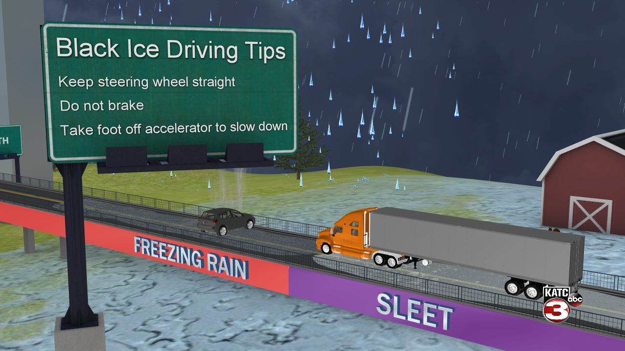
However, road conditions are still very less than ideal.
It is slushy and slick out there, especially on those bridges and overpasses.

Local officials continue to advise motorists to avoid travel if at all possible.
I have noticed some limited peaks of sunshine this afternoon which may briefly melt some ice in spots, but don't let that fool you.
In fact, travel conditions may actually become more dangerous tonight and into tomorrow morning as any liquid on those surfaces will form a thin layer of ice as it quickly re-freezes.
These patches of ice will also likely be harder to see as well, especially at night.
So, keep that in mind if you absolutely must travel and be on the roadways.
All the while, temperatures will be plummeting into the lower-mid teens by tomorrow morning.

In Fact, A HARD FREEZE WARNING and WIND CHILL ADVISORY are in effect until noon on Tuesday.
The record low temperature in Lafayette for tomorrow (February 16th) is 22 degrees, and that is obviously on the verge of being broken handily.
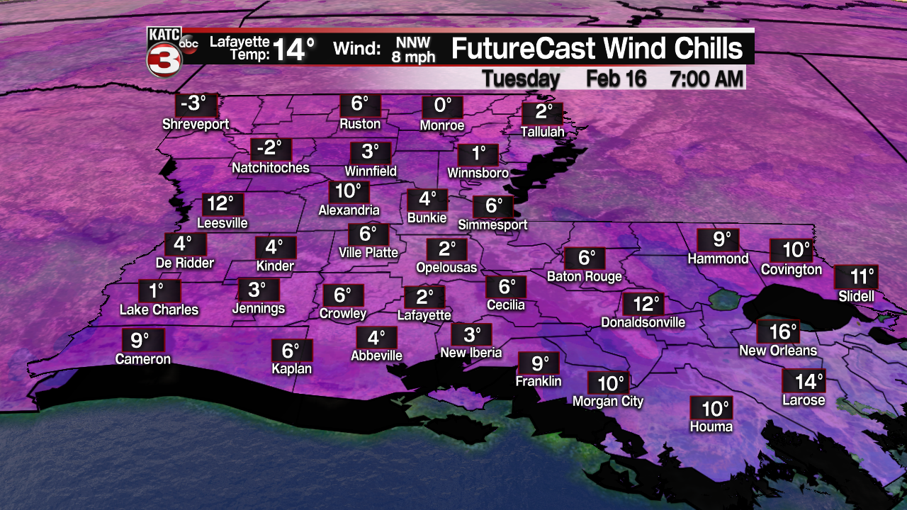
Wind chills will be in the single digits and may even approach sub-0 in spots.
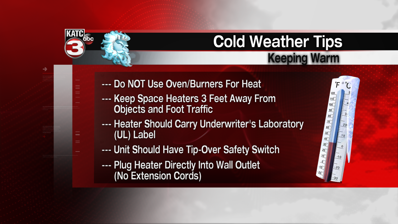
Here is the graph with information on ways to protect your pipes, but this should have already been taken care of this weekend:

Remember that it is always best to consult someone who knows your house better than we do... That includes contacting your local plumber if you have further questions.
Additionally, it probably would not be a bad idea to check in with your neighbors to make sure they are equipped and ready to handle this type of bitterly cold weather.
It is certainly not something we are accustomed to seeing in South Louisiana for sure.
We will see a better amount of sunshine on Tuesday (the more sunshine the better) as temperatures try to climb briefly above freezing.
However, we will be back into the mid-upper 20s by Wednesday morning, so any moisture still on the roadways will re-freeze once again.
Travel will stay hazardous until we get defiantly above freezing.
We'll eventually top out in the lower 50s on Wednesday afternoon.
Another storm system will be approaching late Wednesday afternoon with mainly just a rain event expected through Thursday morning.

However, another winter storm will be setting up once again for our friends in the northern parts of the state.
Around an inch or so of rain will be possible across the area with this system.
Believe it or not, we will once again be eyeing down another hard freeze Thursday night into Friday morning as lows drop back into the mid-20s.
The sun is back for Friday with finally a gradual warm-up into the 60s for the weekend.
Y'all stay warm and safe!
