

Hurricane Ida continues to strengthen. Winds are now 100mph and Ida is now a Category 2 hurricane. Ida continues to look more organized on satellite imagery, with an eye wall now visible.

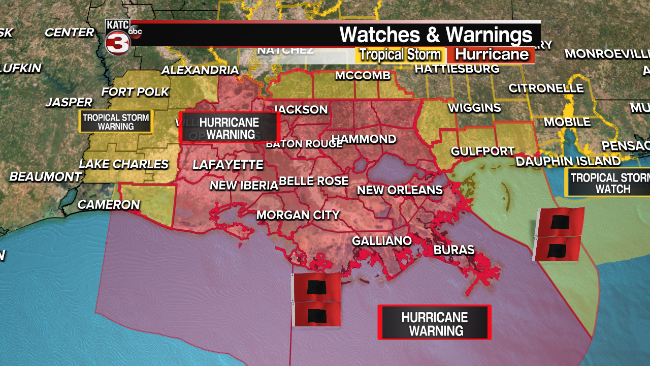
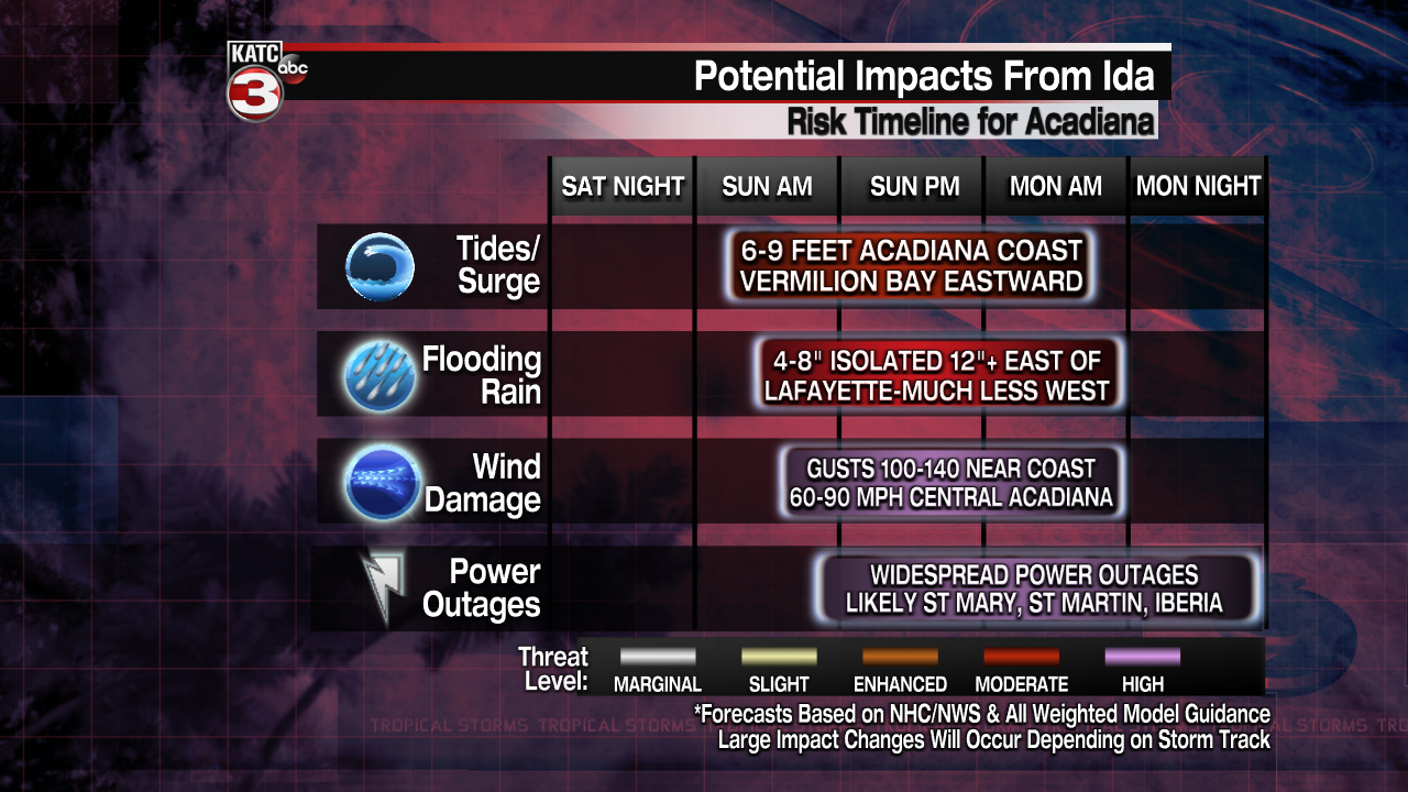
Hurricane Warnings are posted for a large part of Acadiana including, Allen, Evangeline, St. Landry, Avoyelles, Acadia, Lafayette, St. Martin, Vermilion, Iberia and St. Mary Parishes. Tropical Storm Warnings are posted for Cameron, Calcasieu, Beauregard, Vernon, Rapides, Jeff Davis, and Allen Parishes. Warnings mean Tropical Storm and/or Hurricane conditions can be expectd within 36 hours. A storm surge warning is in effect for Vermilion, Iberia and St. Mary Parishes.
Ida is on track to make landfall Sunday as a Category 4 hurricane, and hurricane conditions are likely to be felt over the eastern half of Acadiana as early as Sunday afternoon. Any preparations for staying at home should be completed by Saturday night or early Sunday morning. Those who are evacuating should leave no later than tonight.

Although the track models have been pretty consistent, we're still seeing slight differences in the solutions. The EURO model still brings Ida toward the St. Mary Parish Coast, then lifting over eastern Iberia and St. Martin, before moving northward over the Atchafalaya Basin, then curving toward Baton Rouge.
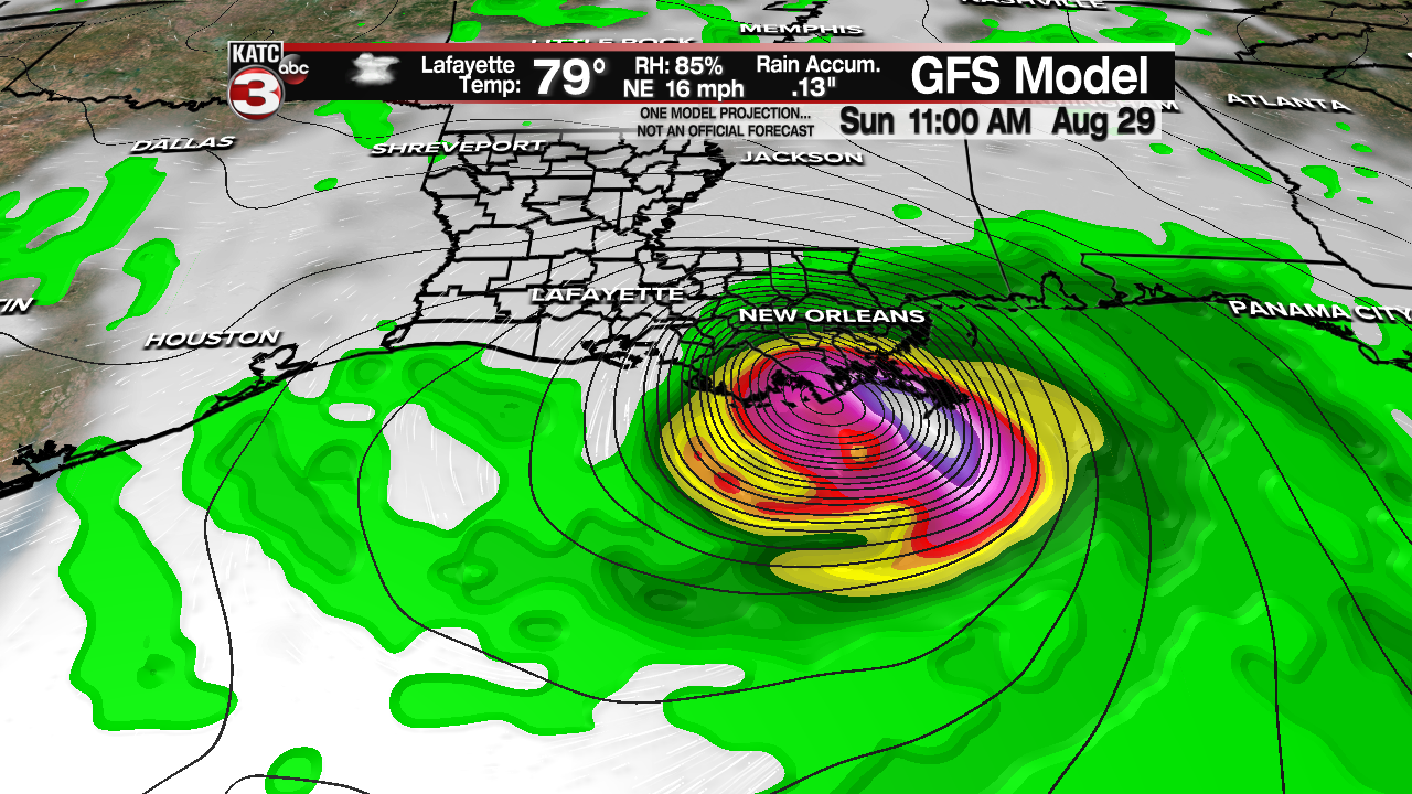
Meanwhile, the Saturday morning GFS is still a bit farther to the east, with a landfall closer to Grand Isle, then progressing toward Baton Rouge. The GFS is also bringing a landfall a little earlier, late Sunday morning. Both of these models are indicating a major hurricane at landfall. This solution would still bring heavy rain and gusty winds to the eastern half of Acadiana, but storm surge would be easier to handle. Keep in mind that storm surge could move in across Iberia and St. Mary several hours after landfall, as the winds will shift back from the southwest pushing water toward the coast.

And finally, the mid morning Saturday GRAF Model has a solution with a landfall also close to Grand Isle. This is much farther west from the earlier run that had a landfall closer to the mouth of the Mississippi. Each of the models are indicating a major hurricane at landfall.
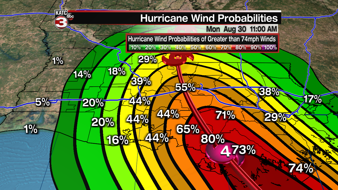
With the official NHC forecast, Ida would likely bring "sustained" Hurricane force winds to the eastern half of Acadiana. Hurricane force "gusts" are possible over Vermiliion, Lafayette and St. Landry. Generally tropical storm force winds will be possible over the western sections of the region.
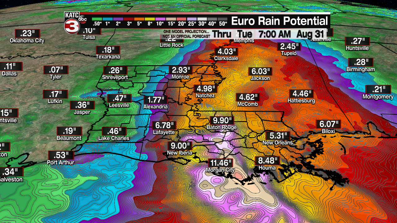
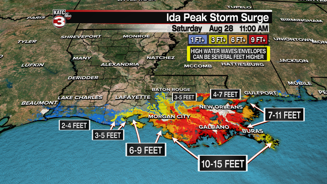
Rainfall amounts are also expected to be much higher on the east side of the system. But flooding could be an issue over the eastern half of Acadiana. Up to 10 inches of rain could be possible over St. Mary, Iberia, and St. Martin parishes. Storm surge flooding is possible along the Iberia and St. Mary coastlines with levels up to 7 feet in some places. Along the Vermilion parish coastline expect up to 4 feet of surge flooding.
As long as the eye wall passes east of our area, storm surge values up to nine feet are possible along the Iberia and St. Mary coasts, with 2-6 feet possible over Vermilion Parish. Lower water levels are expected over Cameron Parish. The surge may come several hours after landfall, especially if it rolls in along the Terrebonne coast, because as the center moves inland, the winds will turn from the southwest, pushing water toward the coast. Any landfall farther westward will increase those values and waters will rise earlier in the storm.
The next update from the National Hurricane Center will come at 1pm, with a full advisory including a new forecast track at 4pm.
