
Like much of the month of February, Acadiana will have to continue to endure an unsettled weather pattern into the first few days of March…before we settle on a winter chill early next week.
In the near term, scattered showers and a few embedded thunderstorms will likely continue into Thursday evening, but most activity should diminish by midnight as an upper level disturbance departs off to the east.
Some fog and/or misty drizzle will be possible later into the overnight hours.
Latest Doppler Radar:
 Power Doppler HD Acadiana View


A weak cool front will slide southward across the region overnight and become nearly stationary just offshore the Louisiana Coast Friday.
Thus temperatures will be a little cooler Friday morning, but should still manage to get back to the upper 60s to lower 70s for Friday afternoon.
Models suggest that there will be the chance of scattered showers, mainly early in the day Friday, with activity tapering for the afternoon.

The same frontal boundary will begin to move back northward Friday night with sea fog and milder temperatures likely to follow into Saturday morning.

Look for breezy and warm conditions to develop Saturday with the chance of scattered mainly afternoon showers and/or a thunderstorm or two, but activity should diminish in time for the Krewe of Bonaparte Parade Saturday evening.

Sunday will be mostly cloudy and quite warm prior to a very strong cold front accompanied by showers and thunderstorms Sunday afternoon.
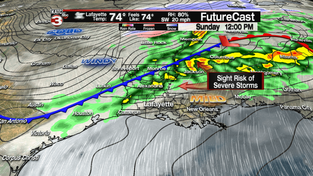
While still early to forecast with any accuracy, Acadiana may be in a “marginal to slight” risk of severe storms, with strongest severe weather dynamics likely well to our northeast, into Mississippi and Alabama per the Storm Prediction Center.
Nonetheless, storms Sunday could produce strong, perhaps damaging winds so stay with us for forecast updates concerning any severe weather potential.
Latest FutureCast:
 Futurecast 3 Hour


Rainfall Sunday should be in the 1 inch range give or take a quarter of an inch, but there could be certainly be higher amounts since we have gotten involved with a more active, and unpredictable El Niño pattern.

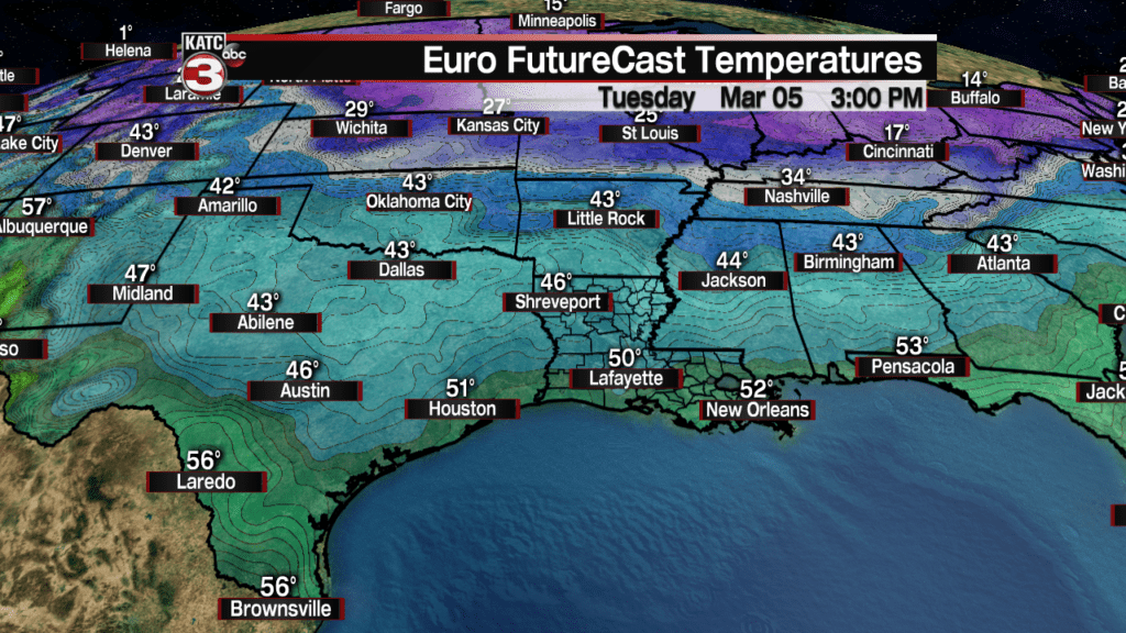
Following the front Sunday temperatures will plummet some 40 degrees, from the upper 70s Sunday afternoon down to the upper 30s to lower 40s by Monday morning.
Gusty northerly winds will drop the wind chills into the 30s, perhaps as lows as the upper 20s Monday morning!
Looks for mostly cloudy skies to persist Monday with temperatures hard-pressed to reach the mid-upper 40s.
Temperatures for the Queen’s Parade in Lafayette will likely be in the lower 40s with wind chills in the low-mid 30s….so dress warmly!
Mardi Gras will be quite breezy and cold, but at least we are expecting mostly sunny skies.
Look for temperatures in the mid-30s Tuesday morning, with wind chills in the upper 20s, to warm to near 50 for an afternoon high around 3-4 pm. Breezy north winds Tuesday will keep wind chills confined to the upper 30s to lower 40s.
Check with KATC’s Mardi Gras Parade and Events Schedule here.
Sunny and cool weather is expected for Wednesday (with less winds so it will feel nice), with highs reaching the mid-50s after the chance of a morning frost and/or light freeze. See the latest 10 Day Forecast.
Clouds and a subsequent warming trend will follow for Acadiana Thursday into the following weekend.
Showers and storms will probably return to the area by next weekend, especially for Sunday.
