


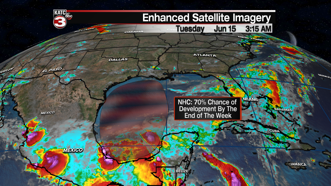
The rumblings from the tropics the last week have continued and the likelihood that the Gulf of Mexico sees it's first tropical system of the 2021 season sits at about 70 percent.
National Hurricane Center forecasters are continuing to monitor a disturbed areas that is sitting in the Bay of Campeche, and will continue to do so through the majority of the work week.
This means that, as is typical with these storms, this is going to be a prolonged forecast with plenty of changes on the way.
It is important to remember that until there is an actual defined low, there will always be uncertainty in the forecast.
That being said let's go through what it is we do know along with what we don't, and what we'll be watching for as we go through the week.
While models continue to indicate further development, they both disagree in regards to specific timing, placement, and overall strength (again, and this will continue to be emphasized there is a lot of uncertainty).
It is safe to say that regardless of timing and location of the storm this one is going to have a typical June look to it, which means you can expect an asymetrical storm with the majority of the impacts east of the center.
So if tracks start getting posted later this week remember to not solely focus on where landfall will be and instead monitor impacts around the center and how they will be effecting your area.
While both the major mid range models keep hinting at a flood threat along the northern Gulf Coast, it's still to early to determined exactly where that flooding threat will take shape, so areas from Sabine Pass to Pensacola will need to continue to monitor this system.
They both seem to think that there will be a narrow corridor of flooding rain that will set up that could produce up to a foot of rain over the weekend, with the heaviest (as of Tuesday morning) expected between the Atchafalaya Basin and Mobile Bay.
Again, we still can't determine exactly where this is going to occur and there will be plenty of changes between now and the weekend.

The above image is the latest run of the GFS model (to keep things simple we will focus on the GFS and the EURO) and it clearly is indicating the asymmetric nature of the storm, producing a bulk of the precipitation east of the center.
This scenario brings the heaviest rains to Mobile Bay with the hot spots of up to a foot occurring along the Alabama coastline, and producing relatively few showers for Acadiana.
In fact, this could bring us a nice breeze from the north depending on the location of the low and could keep humidity lower than normal.

The other scenario worth discussing is the EURO solution which drifts the storm a little further west, indicating a slightly slower storm moving through east Louisiana during the weekend.

This could prove a little more problematic to Acadiana as it would be a wetter weekend than the GFS is indicating, and rain totals would be several inches higher.
Since this model brings the low a little further west it would also drag the hot spots west as well, in this case rain totals of about 12-18" will be possible between the Atchafalaya Basin and New Orleans.
Those kinds of numbers could lead to significant flooding, and flooding will remain the main threat associated with this storm.

This forecast is undoubtedly going to change through the week so keep an eye on how things are trending, specifically with regards to those precipitation hot spots (are the numbers going up or down, or are they sliding east and west).
Make sure to stick with KATC through the week as we continue to get a better sense of the forecast.
------------------------------------------------------------
Stay in touch with us anytime, anywhere.
To reach the newsroom or report a typo/correction, click HERE.
Sign up for newsletters emailed to your inbox. Select from these options: Breaking News, Evening News Headlines, Latest COVID-19 Headlines, Morning News Headlines, Special Offers
