

It felt like it was only a matter of time before the tropics started to pick up and cause meteorologists across the Gulf coast to start monitoring a little closer.
A tropical wave approaching the Caribbean certainly has everyone's attention as it heads to a region with favorable conditions for development.
As of Tuesday (9/20/22) morning the National Hurricane Center has given the system a 50% chance of development by the end of the week.
There's enough model support to suggest that this wave will have a decent chance of developing into stronger system.

There are a lot of questions surrounding this system, as there always is in tropical forecast, so it's important to remember that there's going to be a lot of change and there's still a lot of questions to which we don't have the answers.
That being said let's take a look at what we can look for over the coming days to try and get a sense of what this thing may do, as well as some of the potential outcomes.
Biggest issue in the short term is how quickly this will start to develop, GFS and EURO look completely different with the GFS developing the system before it hits the Windward Islands and the EURO not until it gets into the Caribbean.
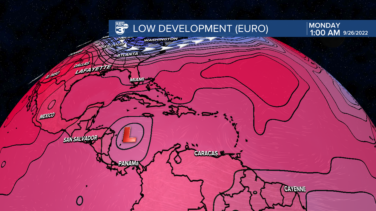
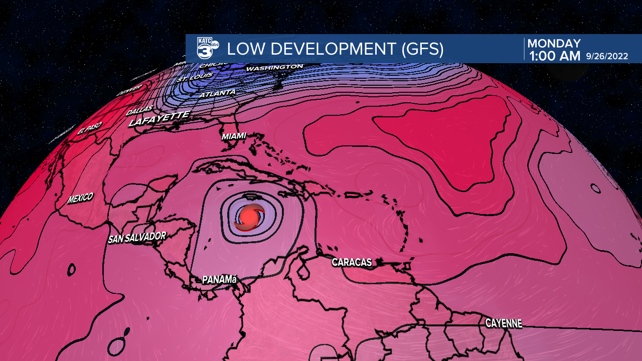
The two graphics above are a side by side comparison of the two models, taken right around the time the EURO develops the wave into a closed low system.
This would be significantly slower than the GFS, which at the same time period has already strengthened the system into a hurricane.
It's worth noting that this wave is following behind Fiona which developed in a similar part of the world, and out performed the models in both intensity and speed of development.
That's no guarantee that this wave will do the same, but it did see a burst of convection and signs of some organization Tuesday morning which caused the NHC to raise the chances up to 50%.
It may not seem like much but the difference in initializing the low can lead to big swings in the overall outcome of the forecast, it's the reason why the forecasts aren't overly reliable before the low officially forms.
There are two things to watch over the next couple of days, the first is how the models trend: Does the GFS slow down development a little, or does the EURO speed up?
The other is seeing if the system is behaving in the way the models have indicated, this can help lend credence to a particular model if it's demonstrating it has a good handle on the storm's behavior.
As of now there's no immediate action to take, and there's nothing imminent on the way but it is something we will need to monitor closely.
At this point everyone from Texas to Florida should start to monitor the storm and be paying attention to it through this week, while keeping in mind that no forecast is set in stone.
We need to answer the big question of initialization first and then we can start taking a look at what forces will be in play for steering.
Elsewhere in the Tropics:
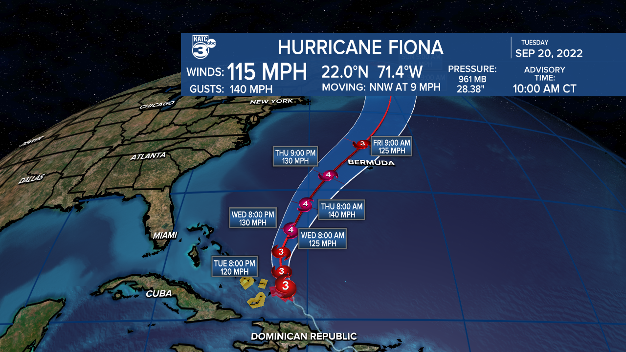
Hurricane Fiona remains a major hurricane with winds around 115 mph as it pushes through the Turks and Caicos.
It will continue to move north and then eventually curve east into the Atlantic and won't pose a threat to the continental United States.
The National Hurricane Center has also started initializing advisories for Tropical Depression 8, although this is going to remain in the Atlantic Ocean so this will likely be my only mention of it.

------------------------------------------------------------
Stay in touch with us anytime, anywhere.
To reach the newsroom or report a typo/correction, click HERE.
Sign up for newsletters emailed to your inbox. Select from these options: Breaking News, Evening News Headlines, Latest COVID-19 Headlines, Morning News Headlines, Special Offers
