


There's still a lot of uncertainty in the forecast, while models have looked pretty consistent especially for handling a developing storm (something they typically don't handle well).
So as you go through the following discussion keep that in mind, this is an evolving forecast and what is true today may not necessarily be true tomorrow.
As stated above, however, models have been in pretty good agreement and have continued to indicate a landfall along the Louisiana coast, so despite that uncertainty it needs to be discussed.
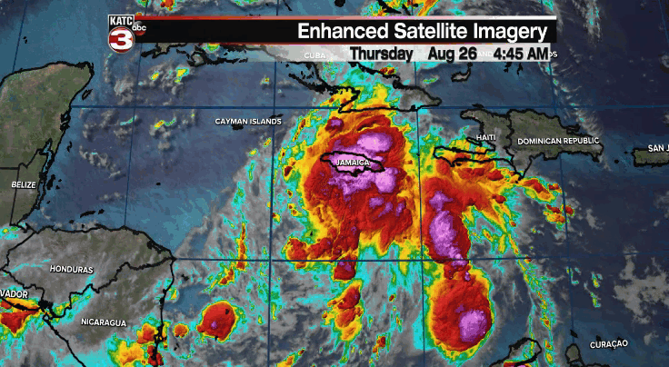
The disturbed area is showing some signs of organization early Thursday, and the National Hurricane Center believes that by Friday we could have an official tropical depression.
Hurricane Hunters are scheduled to fly into the system on Thursday and that is going to be massive in terms of building a little more certainty in the forecast.
It does look like there is a little consolidation on the north side of the area which likely shifts the area of concern out of the central Texas coast and a little more east toward the Alabama/Mississippi border.
Unfortunately for us in Louisiana we will remain in that area of concern.
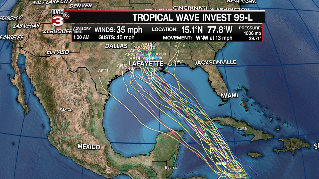
Models have started to focus in on south central and south east Louisiana, but the specifics remain a big question mark and remember that small changes in the track will lead to big changes in specific impacts.
So far our two major models seem to be in decent agreement in regards to the overall track with the biggest difference being in the exact timing of the storm, the GFS moving a little faster and bringing the storm onshore Sunday night and the EURO Monday morning.
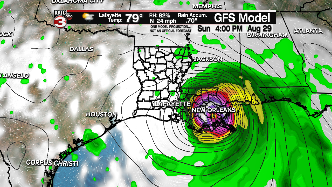
The GFS model is much further east that Wednesday's runs, and this may just be outlier run, but the new data suggests a swing to the east with landfall out in Plaquemines Parish and then running up along the western shore of Pontchartrain and into the north shore.
This does not mean that Acadiana is out of the woods, it's why there's a continued emphasis on uncertainty, it could easily wobble back to the west and pull Acadiana back into the bulls-eye.
Since we're looking at the GFS we can glance at the impacts projected by that model as it predicts a Category 3 storm making landfall in southeast Louisiana as early as Sunday morning.
Rain totals along the eastern half of Louisiana and into Mississippi could be around 10-15" stretched out over several days, the result of a slow moving system, but there is a sharp drop off as you go west away from the storm.
Those number would lead to widespread inland flooding along with major flash flooding through the New Orleans area and communities along the Pearl River, for Acadiana though this particular path would lead to a few tropical downpours but not much sustained.
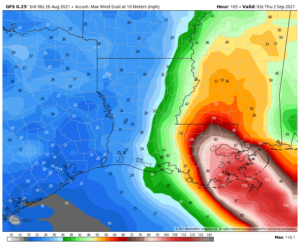
This would bring wind gusts between 110-120 mph through the New Orleans area with sustained winds around the center of the storm close to 111 mph, that would be considered a major hurricane.
Those kinds of winds can stress structures and lead to widespread power outage as power lines would likely be knocked down, as well as toppling trees.
Similar to the rains there is a sharp drop off in the wind as you go west away from the center of the storm.
Please don't take this scenario to mean that Acadiana is completely out of the woods, we've seen the GFS wobble east and west over the last 24 hours and it's entirely possible when the next round of data comes in that it slides back to the west.
This eastern slide in the GFS is likely the response to it picking up on a flare up of activity in Jamaica and initializing the center a little more north than previous runs, hence the eastern shift.
These are the kinds of shifts in the models that having the hurricane hunter data will be able to eliminate.

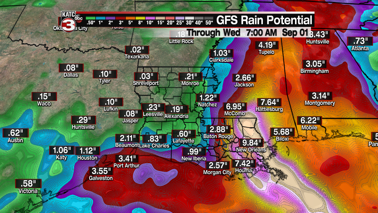
On the other hand, the EURO remains further west and a slightly slower moving storm compared to the GFS and instead brings the storm up on the eastern side of Vermilion Bay as a borderline major hurricane.
This is why Acadiana can't take it's eye off the storm just yet as we are certainly still in play for this storm, and based off of the EURO projections would in line to see major impacts from a storm of this magnitude arriving in St. Mary Parish.
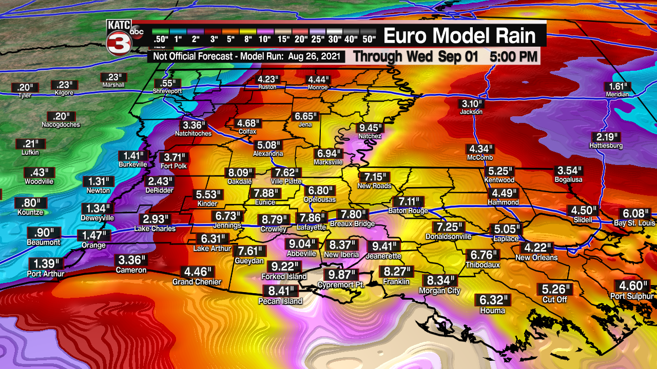
A land-falling storm in St. Mary Parish would bring rain totals of about 10-15" into Acadiana over a several day time period, and would arrive over a shorter time period compared to the GFS as the storm moves inland a little faster.
That kind of rainfall would put a tremendous amount of stress on the local water ways along with significant street flooding, the EURO also paints a slightly messier storm with impacts stretching further out.
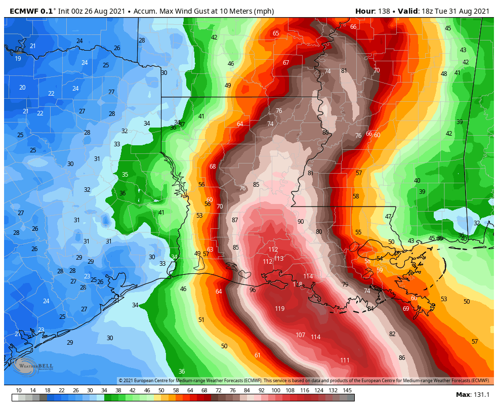
Damaging wind gusts of around 110 to 120 mph would move right up Acadiana knocking down power lines, trees, and damaging roofs.
This would certainly lead to widespread power outages as well as damage to structures.
The EURO is a reminder that we are still very much in the area of concern, and you can expect models to continue to wobble around until we get a well defined low and they have something to focus on.
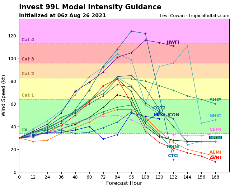
Intensity forecasts are always tough so you can expect changes, but most models seem to agree that this will eventually be at least a Category 2 storm with the potential to be a major hurricane.
The impacts from a storm of this magnitude could be significant and it should be taken seriously, which is why now is the time to review those hurricane plans, with the ability to quickly act on them by the weekend.
It can be very frustrating watching models go back and forth and the hope is that things will settle down and we'll really be able to focus in on the impacts and the track by Friday.
This forecast is certainly subject to change and we will likely continue to see some model variance from run to run so make sure you're staying on top of the forecast.
------------------------------------------------------------
Stay in touch with us anytime, anywhere.
To reach the newsroom or report a typo/correction, click HERE.
Sign up for newsletters emailed to your inbox. Select from these options: Breaking News, Evening News Headlines, Latest COVID-19 Headlines, Morning News Headlines, Special Offers
