


An extended wet pattern will return to Acadiana starting Thursday with high daily rain chances likely to continue through the weekend, and into much of next week.
An upper level and surface trough of low pressure will migrate southward through Louisiana Thursday and then become nearly stationary across the area through the weekend.
These features will allow for a more destabilized atmosphere that will work on the deep tropical moisture trapped in the area to produce daily high chances of showers and thunderstorms into the weekend.

The storms may contain locally gusty winds and the ubiquitous locally heavy downpours that could result in a few inches of rain in an hour or two.

In addition, the Storm Prediction Center does have Acadiana hatched in for a marginal (level 1 out of 5) for the risk of a few severe storms Thursday that could be capable of producing damaging winds.
Localized street flooding may also become an issue from time to time, not only Thursday but for Friday into the weekend as well.

Tropical moisture and instability stays locked in Friday into the weekend with rain accumulations through the next few days likely to be in the 1-3" range for most...and per usual, there will likely be a few hots spots that receive more.
The pattern promises little change next week with upper instability continuing to feed in from the northwest while deep tropical Gulf moisture remains locked in place.
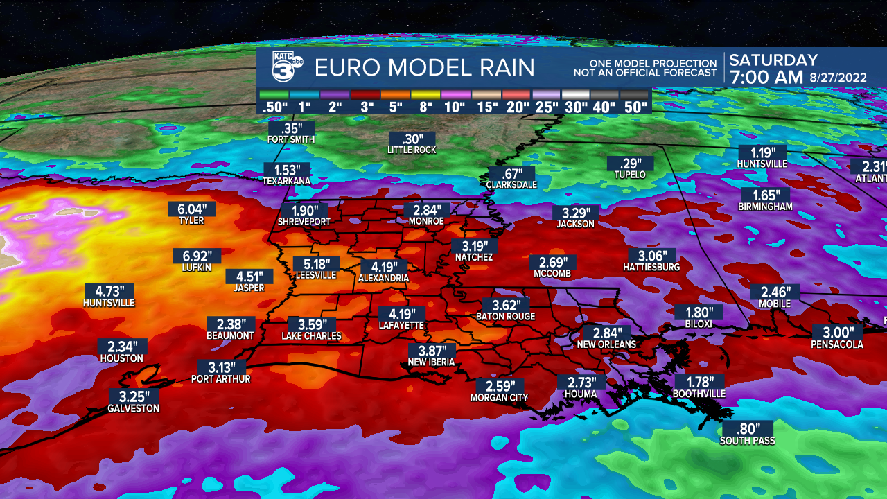
Rainfall totals over the next week to 10 days for most of Acadiana will probably be in the 4-5" range at the very least, and as usual, some spots will likely see more than double that amount accumulate over the next week to 10 days.
See the KATC 10 Day Forecast for the latest.
Meanwhile in the tropics, a disturbance by Belize is expected to move into the Bay of Campeche with a 30% chance of development beginning Friday.

This feature, should bring more heavy rains to portions of Mexico (the Yucatan Thursday and Northern Mexico into this weekend) and perhaps into South Texas and across the Lower Rio Grand Valley.
Some of the moisture from this system could squirt toward Louisiana this weekend insuring more cloud cover and perhaps adding to our rain chances, but it should not be a major player in the overall scheme of things.
Further down the road, it does appear that there might be a few tropical systems to track into next week but it's unclear as to what areas might be directly impacted.

It should be noted that the GFS Model over the last several model runs is pointing to the possibility of some Gulf of Mexico development in the 10-14 day time frame.
There are no concerns for Louisiana at this time, but conditions are certainly expected to become more ripe for tropical activity in the Atlantic Basin (and perhaps the Gulf) as we finish out August and head into early September.
------------------------------------------------------------
Stay in touch with us anytime, anywhere.
To reach the newsroom or report a typo/correction, click HERE.
Sign up for newsletters emailed to your inbox. Select from these options: Breaking News, Evening News Headlines, Latest COVID-19 Headlines, Morning News Headlines, Special Offers
