
Tropical storms form when warm ocean water, moist air, and calm winds come together like engine building blocks. When those favorable ingredients align over the proper area, Easterly waves coming off of Africa can then strengthen into powerful hurricanes.
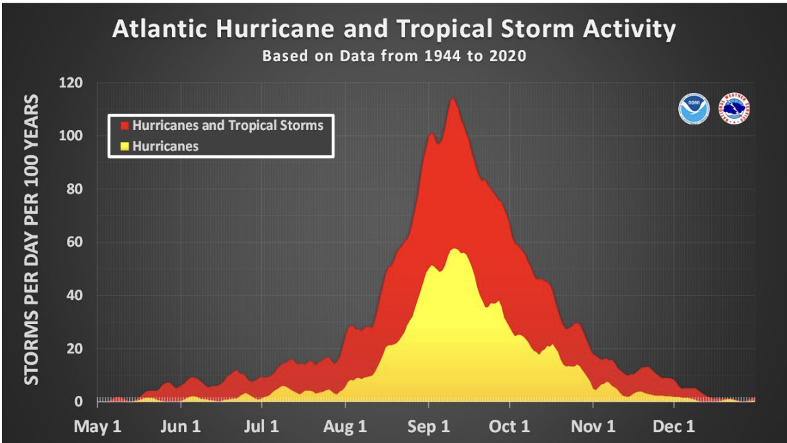
Hurricane season runs from June 1 to November 30, with the peak day of the season falling on September 10. This year, though, the tropics are completely quiet, and if that feels unusual, that's because it is.
This is the first time since 2016 that the tropics are this quiet, and if no named storms form before September 16th, it will mark only the 2nd time since 1950 that has happened for the dates of Aug 29 to Sept 16, the known peak of the season.
The only other time was in 1992, which is important to consider, because it was a destructive year as far as the tropics.
So while the tropics are quiet, they are far from over. In fact, in about two weeks, we are expecting activity to quickly increase.
Let's take a look at what is causing the quiet nature of the tropics even in the peak of hurricane season, and what about that will change and lead into an increase of activity.
First, it's important to know what environmental conditions are needed to develop, strengthen, and maintain tropical cyclones.
Favorable:
- Warm Ocean Water - Acts as storm fuel, the hotter the water, the more energy the system can draw from
- Moist, Unstable Air - You need a group of thunderstorms to get a tropical cyclone going. And thunderstorms need unstable air, meaning air that can easily rise. The air rising also needs to be moist. Moist air is also less dense and lighter than dry air, and rises more readily.
- Calm Upper-Level Winds - Upper-level winds are the winds moving high up in the atmosphere. Tropcial Cyclones are systems that are very tall, and are stacked high in the atmosphere. They are essentially an engine, pulling warm/moist air near the surface and converting it to latent heat through evaporation. For this engine to work, the storm must stay upright, or vertically stacked. If wind shear (a change in either direction or speed of wind with height) is strong/high, the system cannot stay upright, or vertically stacked. This causes weakening. So to be a favorable factor, there needs to be calm/weak wind shear.
- Strong African Waves - These are often the "seeds" that later grow into tropical storms. There needs to be strong convection happening over Western Africa that then moves into the Atlantic where the convection strengthens, and can then gather into a tropical storm.
- Supportive Global Patterns (Teleconnections) - This one is a little tough to understand but chances are you've actually heard of one before. ENSO, is a good example. La Nina or El Nino often influence tropical development, but so does an important teleconnection that is less talked about called the Madden-Julian Oscillation, or the MJO. The MJO is an area of either limited or enhanced convection that rotates in a Easterly direction along the equator in a period of about 30-60 days. This either positive or negatively impacts rising air, by enhancing it or suppressing it. The location of the MJO can either directly, or indirectly impact tropical activity, and we will discuss how it's currently keeping it quiet, but will soon move into an area that will wake up the tropics.
Unfavorable:
- Dry, stable air - Dry and stable air resists rising. And without rising air, you cannot get thunderstorms, or if a wave or cluster is developed, it can be shut off and weakened. Image a balloon that wants to rise, but you've got a lid on it.
- High Pressure Systems - Beneath a high pressure system, you have sinking air/low amounts of clouds. Again, this limits the rising needed. In addition, the airflow direction around a high pressure is important. Air moves around it clockwise, or what we call anti-cyclonically. That means depending on the position of the high pressure, air can come around it from a northern direction, and the further north you go, the more dry and stable air is.
- Stronger Trade Winds - Have you ever wondered what effect the winds blowing over the ocean have on them? Winds play a critical role in cooling off the oceans. As the wind blows over the water, the water churns over, bringing colder water from below it up. So stronger winds will do a better job at cooling the sea surface temperatures, and cooler water is not favorable for tropical storms.
Fun Fact: The cooling actually moves downward in a right deflection as you get lower and lower under the water, called an Ekman Spiral. - A TUTT, or Tropical Upper-Tropospheric Trough - A TUTT brings in dry air and increases vertical wind shear, both disrupt storm formation (we have that MJO to thank for a TUTT formation, more on that later)
- Subsidence (or sinking air) over Africa - As we see again, sinking air is pas bon for developing thunderstorms. If sinking air is hanging out over Western Africa, the seeds of storms we need to get tropical cyclones aren't happening.

Now that we know the basics of environmental factors necessary, let's take a look at where they currently stand.
Many of those unfavorable factors are currently occurring over the Atlantic basin.
A large dome of High Pressure is sitting right over the Eastern Atlantic, it is unfavorable. This is bringing in a large area of sinking air. The High Pressure is also unusually strong for this time of year, so it's really working against allowing storms to sustain themselves if they move into the area. There is also an unusually dry air mass sitting over this area. Why? We talked about the clockwise/anticyclonic flow around a High Pressure system. The stronger the system, the larger it's reach and strength of this flow. What's happening is it is actually pulling in dry, stable air from northern latitudes right over the tropics. Which is pretty unusual for this time of year also. Remember, we said moist air is favorable, dry air is bad for storms. So there is a huge piece to the puzzle missing.

So lets check on Africa, where a lot of our storm "seeds" come from. Africa is unusually dry right now, with lots of stable and sinking air where there is normally more active convection. This is also unfavorable. This causes very weak easterly waves, or our seeds, so we are getting weak starters, and a bad environment, so formation is not happening, and if it does or tries to, it's not lasting either.

The trade winds are also quite strong, which increases wind shear (the vertical change in wind speed or height), another unfavorable factor for storm maintenance and development.
In fact, one of our only favorable factors is the warm sea surface temperatures. This goes to show that high SSTs aren't the full picture.
So, the gulf. We know and have heard it's got strong wind shear, but WHY? There's a reason for everything, and we have a good one for this.
Let's TUTT about it.
A TUTT has formed near the primary formation zone of tropical cyclones for this time of year, which is interesting because those aren't very common during hurricane season. Time to bring in the Madden-Julian Oscillation, our friend or foe, the MJO. The MJO either enhances storm formation, or restricts convection. Has anyone noticed the active Pacific? This was likely a result of a favorable MJO phase enhancing convection over the Pacific. And when the pacific has enhanced convection, down the road from that, in our gulf waters region, a TUTT can form. And that's exactly what's happened. A domino effect of coincidental MJO placement has resulted in the TUTT bringing in dry air and strong wind shear to the gulf, limiting tropical formation. It's always about the pattern and how it falls, rather than one factor or another on it's own.

Once ALL of that is combined, and happening at once, tropical activity slows to halt, however, none of these things are permanent, in fact, most of them can change in as little as a few weeks, and they are foretasted to do just that.
The strong high pressure over the Eastern Atlantic is forecast by the Euro model to weaken significantly, reducing the strength of that sinking air, and also that systems ability to bring in dry air over the Atlantic from the North, so that storms that enter into the Atlantic can much easier form, maintain strength, and with favorable sea surface temperatures, rapidly intensify.
BEFORE
AFTER

The MJO is going to continue to propagate Eastward, meaning areas of enhanced convection will actually move over Africa. Our seeds will not only stop fighting sinking air, but they will get an environmental buff, and actually have help rising. And once storm activity increases over Western Africa, we should see the seasons activity quickly pick up. And now we have healthier starts to these tropical cyclones, and they will move into much more favorable conditions in the Atlantic.

As far as closer to home near our gulf waters, a TUTT naturally decays, weakens, and moves south->southeasterly with time. So this will remove what's been limiting convection, and all of this is expected to happen around the same time.
So the bottom line? Why it's all important?
YES, the normal peak time of the season is quiet, but that will change, don't drop your guard. Continue to stay prepared, use the quiet time to review your safety plan, hurricane kit, review insurance, take pictures of your home, and things like that.
Remember, last year we had catastrophic storms Helene and Milton. Helene occurred in late September, and Milton happened in October.
It's not over until it's over.
That is your HEFTY science lesson for today, if you made it this far, get yourself a little treat to celebrate, I'm proud of you.
I want to acknowledge the writing today on this topic by Philip J. Klotzbach and other authors on their team from Colorado State.
For a more technical and informative look, it can be read here
Source: Colorado State University Tropical Meteorology Project, seasonal hurricane forecast discussion, Sept. 9, 2025.
