Current Conditions
We're starting off with partly cloudy skies and muggy conditions across Acadiana. Temperatures are hovering in the 90s with dew points in the low to mid 70s, creating that sticky feel we've come to expect this time of year. There are some ongoing coastal storms that will eventually die down with the sun, and we will see this rinse and repeat throughout the week. Although the rain can be annoying, daily chances will keep temperatures at least somewhat regulated while the rest of the North-East faces a strong heat wave as a heat dome sets up overhead with us just to the south of it.

24-Hour Outlook
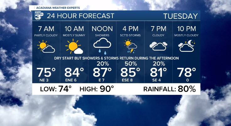
Expect a dry and mostly sunny start Tuesday morning with temperatures quickly climbing through the 80s reaching for the 90s as a high. By midday, scattered showers and storms will begin with daytime heating reaching it's maximum. Afternoon highs top out near 90°, with heat index values closer to 102° for most of Acadiana. Storms are regular afternoon convection, with the primary threat being lightning risks. Remember, if you hear thunder, you are at risk and should be indoors.
The highest storm coverage comes Tuesday afternoon, with rainfall chances sitting at 80%. Localized downpours, gusty winds, and frequent lightning are all possible, though widespread severe weather is not expected.


Next 3-Day Forecast
- Tuesday: High: 90° | Rain: 80% | Heat Index: 102°
- Wednesday: High: 90° | Rain: 60% | Muggy with more scattered storms
- Thursday: High: 90° | Rain: 50% | Slightly drier, still hot and humid
Afternoon storms remain hit-or-miss, a typical setup for late June in Louisiana. Expect daily activity to peak mid- to late-afternoon and fade near sunset.


Next Weather Maker
A strong upper-level ridge—or "heat dome"—continues to dominate the Eastern U.S., helping to push Gulf moisture into Acadiana from the south. While we won’t see the same extreme heat as the Northeast, the added moisture here keeps conditions uncomfortably humid.
As we head into late week and the weekend, the upper-level pattern relaxes slightly, but scattered storms remain a fixture each day with around 40–50% coverage. No strong frontal boundaries or organized systems are expected to sweep through at this time. We are locked in, as they say.

Tropical Update
The National Hurricane Center continues to monitor a tropical disturbance (AL90) in the central Atlantic. As of now, it has a 60% chance of development over the next two to seven days. Fortunately, current model guidance keeps the system well out to sea and no threat to land is expected at this time. Will we see it become Andrea? Looks possible. But if so, she will be a fish storm.
It's a good reminder that hurricane season is heating up, and now’s the time to review your plans.

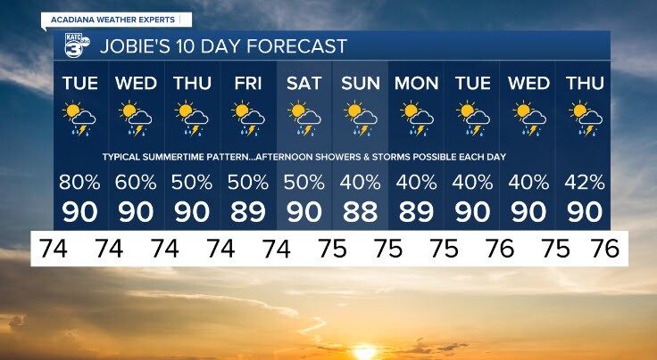
10-Day Forecast
A classic summertime pattern continues with temperatures holding steady in the upper 80s to near 90° each day and lows in the mid 70s. Daily storm chances range from 40–60%, with the highest risk Tuesday before slowly tapering late week, but that only relatively lowering chances of rain, that are a continuous and expected part of the forecast. Expect a mix of sun and clouds and potential for locally heavy rain in stronger