


Acadiana's weather looks to remain hot and humid with the chance of scattered afternoon storms for the foreseeable future.
In the near term, thanks to plenty of cloud cover, Acadiana's 4th of July afternoon topped out near 90°....but it will be hotter Saturday and Sunday.
And with the heat and more expected sunshine, our afternoon readings will approach 93-94° across the area, accompanied by heat indices reaching the 100-105° range.

Scattered pop-up showers and a few storms are expected to develop for Saturday afternoon with rain chance near the 30% range.
A better chance of scattered afternoon thunderstorms are expected Sunday into early next week with afternoon rain chances increasing to 50-60%.
The heat, humidity and chance of scattered storms will continue through much of next week, and it appears, into the following weekend.
However, we're not expecting any significant organized severe weather nor heavy accumulated rains through the next week to 10 days.
But with that being said, any pop-up storm that develops in the days ahead could bring brief heavy downpours, frequent lightning and gusty winds...perhaps a few funnel clouds too from time to time.
See the KATC 10 Day Forecast for the latest.
Meanwhile in the tropics, Hurricane Hunters discovered that Tropical Depression #3 has formed off the South Carolina Coast Friday afternoon.

Tropical Storm Watches were posted for portions of South Carolina.

TD#3 is lopsided at this time with worst conditions in the eastern semi-circle of the depression and is expected to become a weak tropical storm prior to landfall, if so, its name will be "Chantal"..
The system is expected to drift north-northwestward and move inland over the southeastern U.S. by early Sunday morning.
Most of the heavy rains with this system should manifest offshore, but rough seas/surf and some gusty winds will impact portions of the Carolina Beaches this weekend into early next week.
Finally and back to our west, incredible and catastrophic rainfall amounts from a nearly station thunderstorm complex has produced a foot, to a foot and a half of rain in the last 24 hours across portions of Central Texas.
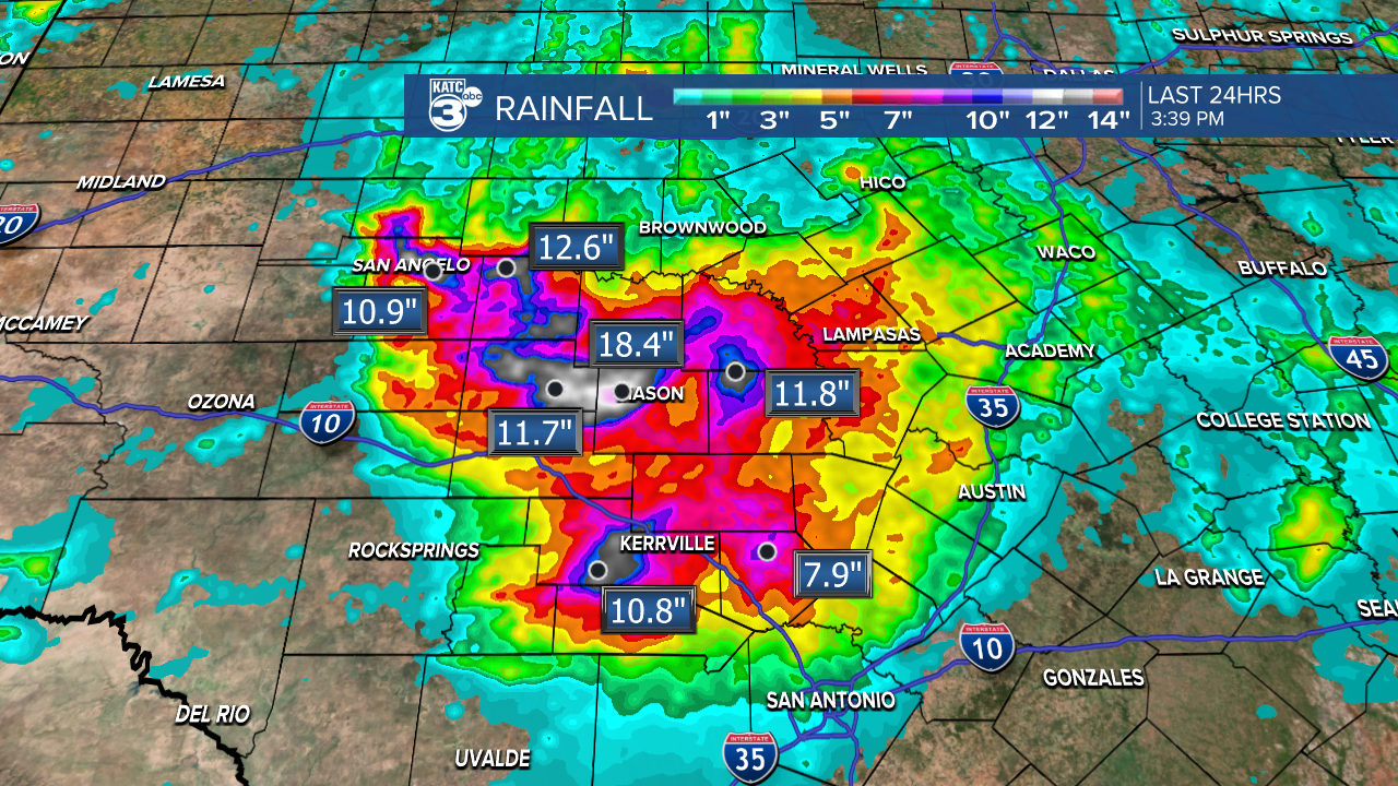
In some spots, this is more than 6 month's worth of rain.
