


After one of the wettest May's and the wettest spring on record, Acadiana looks to continue the soggy pattern at least for the first week of June.
A series of upper disturbances rolling out of the west will interact with Gulf moisture to produce better than normal daily rain chances into the weekend.

Showers and storms will be primarily on a scattered basis over the next couple of days, but additional energy and instability will arrive late in the week and into the weekend allowing for even higher rain chances...and perhaps the increased threat of some flooding.

This will also keep our temperatures below normal for the time of the year.
In the near term expect daytime rain chances to be in the 50-60% range this week while at night shower activity should be limited to 20-30%.
By the weekend, rain chances may increase closer to 70-80% and with that, a greater possibility of some localized flood threats.
As always, it's impossible to forecast which areas will see the most rain or where flooding will be most likely, but we can say for sure that rain totals over the next week to 10 days will likely be somewhere between the 3-8" range...and per usual, there may be much hotter spots possible.
The GRAF model over the next couple days pains a picture of hit or miss shower and thunderstorm activity so rain totals should generally be less than an inch or two.

But per the Weather Prediction Center (WPC), and our most recent deterministic models pain a alarmingly wet scenario.

The WPC is calling for rain totals for Acadiana in the 3-5" range, while the operational models continue to hint at more.
The Euro Model does paint the wettest picture for our area at this time, but in general, we can probably expect anywhere from 4-8" of rain over the next 10 days.

It will not come all at once for most of us, but it's conceivable that the Acadiana area may see a couple of days where rain rates and totals could lead to the threat of localized flooding, and that threat would most likely be toward the weekend.

The bottom line, after the second wettest May on record for Lafayette, and the wettest sporing on record from Lake Charles to Lafayette, and with grounds still nearly saturated accompanied by abnormally high river and bayou levels, this type of forecast is not a welcomed one.
See the KATC 10 Day Forecast for the latest.
Climate notes:
May 2021 numbers...2nd wettest May on record for Lafayette...6th wettest month on record...and wettest spring on record!

Per the National Weather Service:
Lafayette (records date to 1893)
-19.17" in May was 2nd wettest (record: 22.24/1907)
-30.83" in Spring was wettest (old record: 30.12/1926)
-6.37" on 5/17 was 6th wettest May day (record: 10.38 5/16/1980)
New Iberia (records date to 1948)
-17.61" in May was wettest (old record: 14.06/1991)
-28.29" in Spring was wettest (old record: 27.53/1991)
-6.08" on 5/11 was 10th wettest day overall (13.54 8/12/2016)
Lake Charles (records date to 1895)
-20.50" in May was 3rd wettest (record: 21.45/1907)
-31.83" in Spring was wettest (old record: 31.31/1980)
-12.49" on 5/17 was 2nd wettest May day (record: 15.67 5/16/1980)
-12.49" was 3rd wettest day overall (record: 15.79 6/19/1947)
Tropical Update:
Today is the first official day day of hurricane season.
Statistically-speaking it's highly unlikely that Louisiana will see a repeat of 2020. But no matter what the predictions are, as we all know too well...it only takes one storm to make it a bad season.

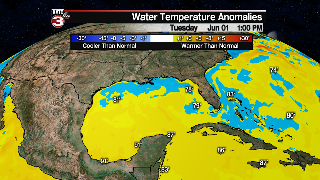
Today's tropical notes: The Northern Gulf and Bahamian water temps are a little below normal for the time of year and there are no suspect areas today nor any development expected through the next 5 days.
List of this year's names are below:

------------------------------------------------------------
Stay in touch with us anytime, anywhere.
To reach the newsroom or report a typo/correction, click HERE.
Sign up for newsletters emailed to your inbox. Select from these options: Breaking News, Evening News Headlines, Latest COVID-19 Headlines, Morning News Headlines, Special Offers
