


A bit of a dreary pattern has set in across Acadiana with showers likely through Friday and lingering cloudiness and some rain chances persisting into portions of the weekend.
In the near term, look for showers to develop and expand across most of Acadiana through the overnight hours with highest rain chances (near 80-90%) after midnight and toward daybreak Friday.

Showers will persist into Friday with activity tapering during the afternoon/evening hours.
Temperatures will remain on the mild side overnight with lows through Friday morning in the low-mid 60s.
Readings will begin to cool Friday night with temperatures bottoming out Saturday morning in the mid-upper 50s and likely staying in the 50s (at best lower 60s) for most of the day with the slight chance of lingering showers early.
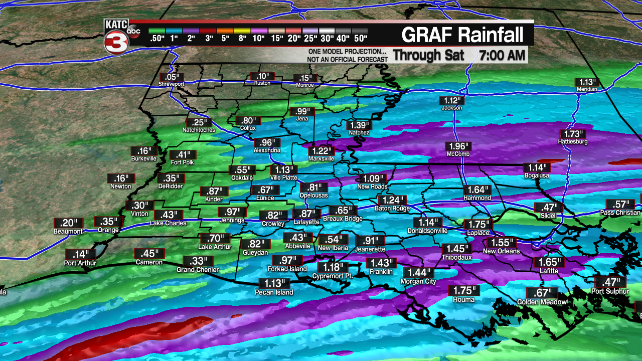
Late model runs Thursday are now indicating that rain totals through Saturday morning will generally be in the 1/2-1" range...a few spots might see up to 2" but there should be no flooding rain nor and severe weather threats.
A rumble of thunder however, cannot be ruled out for early Friday.

Plenty of clouds will linger this weekend with temperatures rebounding back into the lower 70s Sunday afternoon as southerly winds return to the area.
A few glimpses of sun may also be possible Sunday afternoon.
Another good chance of showers, and perhaps a few robust thunderstorms will return to the area Monday with highs pushing the spring-like mid-70s.

There could be a low-end severe weather threat for our area Monday but it's to early to make that call.
Mostly sunny skies will return Tuesday but yet another weather system should bring back the chance of precipitation for Wednesday.
A couple of nice days should follow later next week with another potential system impacting the area by the end of the following weekend.
See the KATC 10 Day Forecast for the latest...you will notice plenty of 60s and 70s and fewer 50s during the day and mostly 50s and a few 40s at night.
While we can't say that we are done with the cold weather in Acadiana, longer range outlooks look rather mild well into February...but we could also see 30s into early March which would be par for a La Niña pattern that is expected to continue well into the spring,
------------------------------------------------------------
Stay in touch with us anytime, anywhere.
To reach the newsroom or report a typo/correction, click HERE.
Sign up for newsletters emailed to your inbox. Select from these options: Breaking News, Evening News Headlines, Latest COVID-19 Headlines, Morning News Headlines, Special Offers
