


The odds of development of a tropical depression or lower end tropical storm in the Gulf remains high (near 90% per the National Hurricane Center) before the end of the week, with impacts likely for Louisiana into this weekend.

Based on Wednesday's model trends, although the center of this potential system is likely to make landfall near or in Acadiana late Friday night into Saturday morning, the threat of heavy, flooding rains has shifted to the east.
Of course with any developing system, there can be lots of changes in the forecast, but today it is looking better for Acadiana than it did yesterday.

Nonetheless, there will be the chance of a depression or lower end tropical storm impacting Acadiana with high rain chances arriving Friday evening/night and carrying through much of the day Saturday.
It appears there will be enough upper level support to push the system east/northeast of our region into Sunday.

And with today's model suite taking the system farther east, the threat of flooding rains for now appears to be lower for Acadiana.
For now, we are going with the possibility of 2-5" of rain for the area with much higher amounts likely farther to the east, into Eastern Louisiana, Mississippi, Alabama and perhaps the Florida Panhandle.

Fortunately the Euro, GFS and GRAF models are in sync with this scenario which builds more forecast confidence in what is otherwise a relatively low confidence forecast.
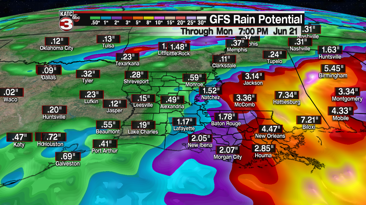
Much lower rain amounts, if any, will be found to the west toward Lake Charles and the upper Texas Coast.
For now, there is not much in the way of an inland wind threat anticipated, but gusts offshore may approach the 40-50 mph range by late Friday night into Saturday.

In addition, coastal Acadiana tidal levels could increase as high as 2-3 feet late Friday into much of the weekend. Tides will likely be higher farther to the east.

But with no identifiable low pressure system as of late Wednesday afternoon, the forecast will be subject to change, and there could be large swings in the forecast for Acadiana depending where a dominant low takes hold prior to landfall.
So stay with KATC, katc.com and KATC social media for any possible changes.
The worst weather and soaking rains for Acadiana is expected to arrive into portions of the area Friday night with highest rain chances Saturday.
Thereafter the forecast calls for daily daytime showers and storms for Sunday and much of next week, so enjoy the dry weather we see in the near term through Thursday!
Consult the KATC 10 Day Forecast for the latest.
------------------------------------------------------------
Stay in touch with us anytime, anywhere.
To reach the newsroom or report a typo/correction, click HERE.
Sign up for newsletters emailed to your inbox. Select from these options: Breaking News, Evening News Headlines, Latest COVID-19 Headlines, Morning News Headlines, Special Offers
