


10PM TUESDAY UPDATE:
Zeta's appearance was improving on satellite imagery and was very close to becoming a hurricane within hours.
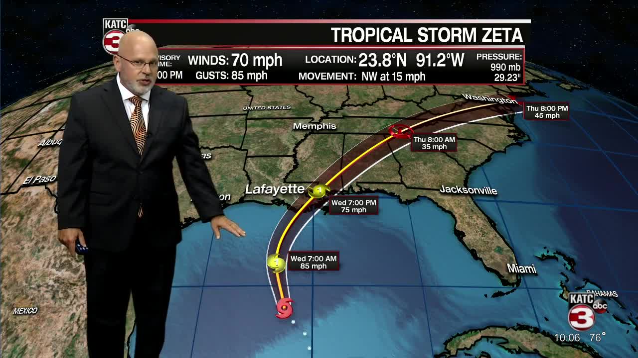
No big changes to the track of Zeta...still a tropical storm for the 10pm advisory, but expected to re-intensify to a hurricane overnight and gain strength up until midday Wednesday before running into stronger wind shear aloft and over cooler Gulf of Mexico water temperatures.
Zeta is still expected to make landfall as a hurricane in extreme Southeast Louisiana Wednesday evening and possibly remain a hurricane for a second landfall on the Mississippi Coast later Wednesday night.
---------------------------------------------------------------------------------------------------------------------------------------------
While most, if not all direct impacts from Zeta should manifest east of Acadiana, we'll also be watching (and looking forward to) sharply cooler temperatures that will follow behind the storm.
Zeta, a tropical storm with 65 mph winds as of 4 pm Tuesday, is expected to regain hurricane status overnight making landfall Wednesday evening over extreme Southeast Louisiana as a Category 1 storm, and will be racing rapidly to the northeast impacting coastal Mississippi several hours later.
It appears that all the damaging wind gusts, in the 70-90 mph range, will follow right near and northeast of the center of Zeta's circulation...areas well east of Acadiana.
Projected Zeta wind gusts and power outage potential:
And because the storm will be moving quickly...highest rain totals should be limited to 6 inches or less near the center and east of the storm's circulation, with just scattered tropical showers and less than an inch or two of rain expected for Acadiana proper.
Locally, scattered tropical showers will be possible for Acadiana any time overnight Tuesday into Wednesday, and early Wednesday evening, with rain chances in the 60-70% range.
The highest wind gusts in Acadiana are expected for the eastern-most portions of St Mary Parish where gusts could approach the 35-45 mph range at worst (and that may be a stretch)...elsewhere, just a breeze for the rest of Acadiana is anticipated near 15-25 mph or less.
The bulk of any power outages will likely be limited to extreme Southeast Louisiana and perhaps into coastal Mississippi.
Along the Acadiana Coast, tides are expected to increase to 1-3 feet above normal (including for Vermilion Bay) by Wednesday evening, bit should subside rather quickly into Thursday as west-northwest kick in Thursday.
As the storm passes to the east of Acadiana Wednesday night, expect a strong cold front to push through the area with temperatures turning sharply cooler by Thursday morning...in the upper 40s to lower 50s.
Mostly sunny, breezy and cool weather will ensue for Acadiana Thursday with cool and dry weather to last well into next week.
Daily high temperatures will be topping out in the mid-upper 60s into the weekend while overnight lows dip into the 40s...perfect gumbo weather!
See the KATC 10 Day Forecast for the latest and stay with KATC on Zeta coverage should there be an unexpected change in the storm's landfall and/or intensity.
------------------------------------------------------------
Stay in touch with us anytime, anywhere.
To reach the newsroom or report a typo/correction, click HERE.
Download our free app for Apple, Android, Roku and Amazon devices.
Sign up for newsletters emailed to your inbox. Select from these options: Breaking News, Evening News Headlines, Latest COVID-19 Headlines, Morning News Headlines, Special Offers
