


After a chilly start expect a mild finish for Acadiana Thursday under mostly sunny skies.
Temperatures will start out in the the low-mid 40s across the area...perfectly normal for early February!

But our April sun will warm us nicely into the afternoon with highs pushing the low-mid 70s.
Acadiana's next weather-maker will roll out of the Desert Southwest through Thursday and engender low pressure development in Texas to the ArkLaTex Friday.

Clouds and southerly winds will increase Friday along with the chance of scattered showers and some thunderstorms possible, especially into the afternoon...it appears that our best storm chances will arrive Friday night.

Showers and thunderstorms are expected to become likely Friday night with the next frontal boundary and there could be a severe weather threat as well.
The Storm Prediction Center (SPC) has Acadiana hatched in for a marginal to slight risk of severe storms into Friday night that could be capable of producing damaging winds, hail and perhaps a few isolated tornadoes.

The greatest risk of severe weather in the state Friday into Friday night appears to be more likely from Central into Northern Louisiana, and that's likely where the heavier rains should manifest as well.
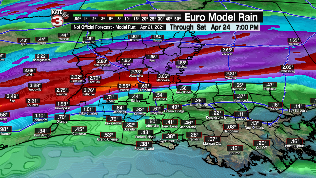
For now, most of the area should see less than an inch of rainfall, with several inches (along with a slight risk of excessive rainfall) more toward the central and northern part of the stat per the Euro and GFS models.

Showers and perhaps a few rumbles of thunder should end early Saturday with plenty of sunshine returning for the afternoon.
Sunday looks spectacular with wall to wall sun accompanied by highs in the upper 70s.
After a couple of quiet days early next week, we should see another round of storms around next Wednesday...and there could be another lower end severe weather threat for the area again.
See the KATC 10 Day Forecast for the latest.
------------------------------------------------------------
Stay in touch with us anytime, anywhere.
To reach the newsroom or report a typo/correction, click HERE.
Sign up for newsletters emailed to your inbox. Select from these options: Breaking News, Evening News Headlines, Latest COVID-19 Headlines, Morning News Headlines, Special Offers
