


Stormy weather will be possible for Acadiana Wednesday night as a weakening frontal boundary combined with a robust upper pattern may produce some strong, to possibly severe storms across the area.
In the near term, expect skies to go from fair to mostly cloudy overnight holding our temperatures closer to the mid-60s for morning lows.
Look for mostly cloudy, breezy and warm conditions Wednesday ahead of our weather system with a few intervals of sun possible along with the very slight chance of a quick, passing shower, at 20% or less.
Temperatures Wednesday will push into the balmy lower 80s along with an increase in more noticeable humidity.
Showers and storms will become likely Wednesday night with the possibility of a few isolated severe storms that could be capable of producing damaging winds, and perhaps some hail.

While the threat of any tornadoes is not zero, the best chance for a few storms capable of producing such would be more toward the northern part of the state and into Mississippi.
The Storm Prediction Center (SPC) has all of Acadiana hatched in for a "marginal risk" of isolated severe storms while the northern part of the state is hatched in for a more elevated "slight" risk, where there should be a a more pronounced threat of tornadic activity.

In fact the SPC has stated there could be an upgrade to an "enhanced" risk of severe storms in the slight risk area in subsequent forecast updates.
The bottom line for Acadiana, there could eventually be a tornado or severe thunderstorm "watch" issued for portions of the area (especially northern sections) at some point tomorrow evening/night...but odds are in the 50/50 range for that at this time.
Remember, we can and often do see severe storms even if a "watch" is not issued for the area.
The storms should clear the area by daybreak Thursday.
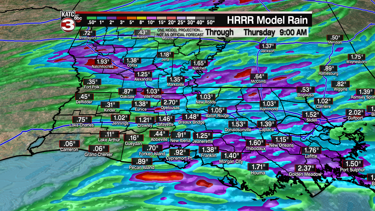
While flooding is not anticipated, there could be a few isolated storm areas that receive up to 2-2.5" of or rain, while most of us will likely see an inch or less.
A break in the active weather is anticipated for Acadiana Thursday, with a more unsettled pattern developing late Friday into the front end of the weekend.
Showers and storms look to be a good bet for the area again by Friday night into early Saturday with the distinct possibility of at least another "low-end" severe weather threat.
Any storm activity looks to end later Saturday, and with any luck, we'll squeeze out a nice Sunday.
See the KATC 10 Day Forecast for the latest.
------------------------------------------------------------
Stay in touch with us anytime, anywhere.
To reach the newsroom or report a typo/correction, click HERE.
Sign up for newsletters emailed to your inbox. Select from these options: Breaking News, Evening News Headlines, Latest COVID-19 Headlines, Morning News Headlines, Special Offers
