


Showers and some strong storms will become likely for Acadiana Thursday night followed by a drier and hotter weekend...but wait there's more...as daytime temperatures next week will be pushing toward the mid-90s!
In the near term, expect another quiet evening ahead with clouds returning by daybreak Thursday. Temperatures will bottom-out in the lower 70s.
Thursday will be a breezy and warm day with low-end rain chance under a sun and cloud mix.
Look for a high Thursday near 87° with breezy southerly winds gusting to 20-28 mph during the afternoon.
A vigorous disturbance that will be producing a significant severe weather threat well to our north and west overnight will advance eastward Thursday likely swinging the tail end of some strong storms into our region Thursday night.
The Storm Prediction Center (SPC) has most of Acadiana in a marginal to slight risk (levels 1 and 2 out of 5) for severe storms Thursday night ending early Friday.

The main concern for our area would be for storms that could produce isolated pockets of damaging winds and some small hail.
There may be a tornado or severe thunderstorm "watch" posted for portions of our area going into Thursday evening, with the most vulnerable areas, per usual, to the north.

Severe or not, expect storms containing gusty winds, torrential downpours and frequent lightning to impact our area.
Storm "prime-time" (subject to change) appears from 9-10 pm through about 3-4 am Thursday night/Friday morning.
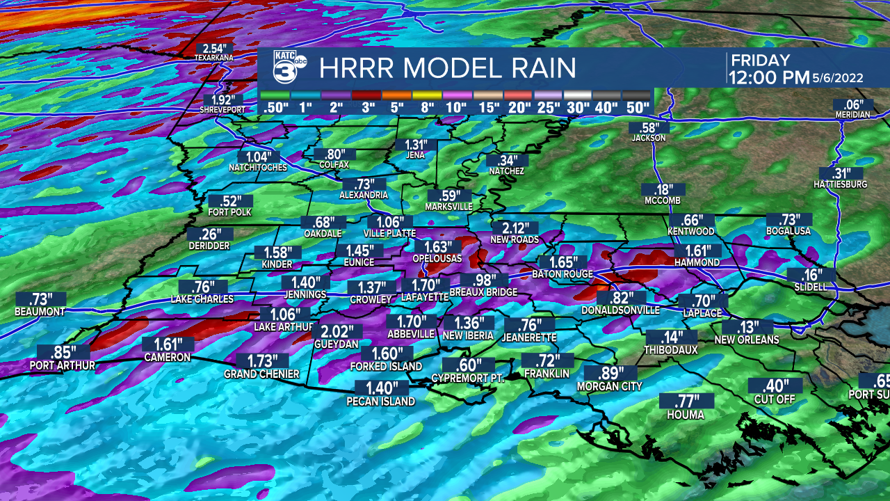
Rain totals of 1-2" can be expected with isolated spots perhaps catching 3-4" where storm repeat.
Some lingering storms may be possible into Friday but look for more sun and temperatures to warm into the upper 80s with a few 90° readings possible before the afternoon is done.
The weekend is looking fair to partly cloudy and quite warm with afternoon highs pushing toward the lower 90s...we didn't see our first 90° reading last year until June 9th...this year it will come a month earlier!
Next week looks more like July than May as an upper ridge of high pressure builds across the region amplifying our heat.
High temperatures mid-late next week could push the mid-90s, which if the forecast verifies, would put us in record territory for the time of year.
And having a little heat wave like this early in the year will likely translate to the perception (and reality) of an extra long and hot summer!
There are no cool fronts on the horizon, perhaps through the rest of the month...and possibly for the 3 to 4 months to follow!
See the KATC 10 Day Forecast for the latest.
------------------------------------------------------------
Stay in touch with us anytime, anywhere.
To reach the newsroom or report a typo/correction, click HERE.
Sign up for newsletters emailed to your inbox. Select from these options: Breaking News, Evening News Headlines, Latest COVID-19 Headlines, Morning News Headlines, Special Offers
