Acadiana is expected to remain in an unsettled and stormy pattern into Wednesday, and perhaps, Wednesday night, with a slight risk of severe storms also in the mix until a weak front arrives late Wednesday night.
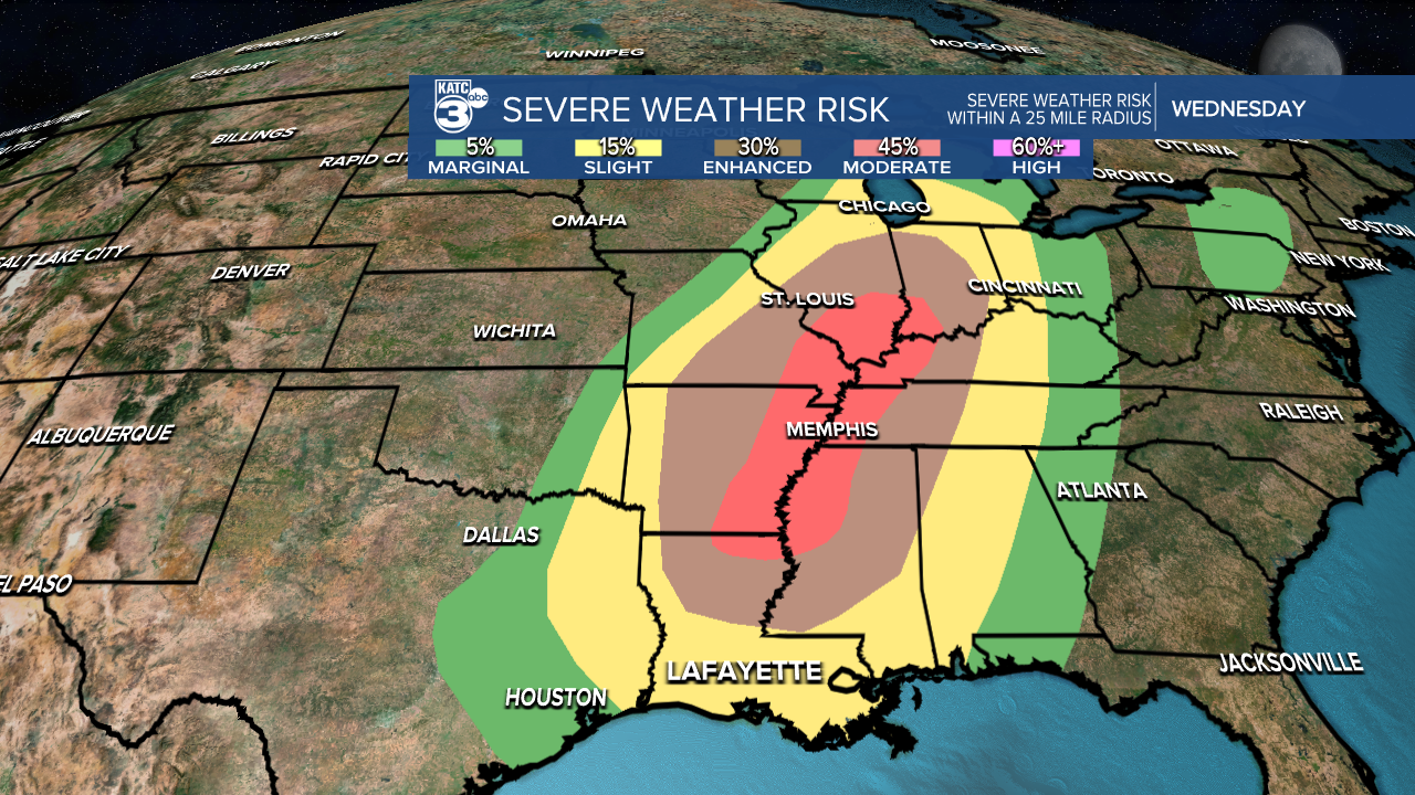
![Storm Threats.png](https://ewscripps.brightspotcdn.com/dims4/default/59be7fc/2147483647/strip/true/crop/1280x720+0+0/resize/1280x720!/quality/90/?url=http%3A%2F%2Fewscripps-brightspot.s3.amazonaws.com%2F11%2F2a%2Fc3c58b754e75a8f8c0d4176bff2b%2Fstorm-threats.png)
The Storm Prediction Center (SPC)has all of Acadiana hatched in for the "slight" risk of severe storms this Tuesday evening into the overnight hours, and again into Wednesday/Wednesday evening.
![swody1.png](https://ewscripps.brightspotcdn.com/dims4/default/6c59ddb/2147483647/strip/true/crop/1280x720+0+0/resize/1280x720!/quality/90/?url=http%3A%2F%2Fewscripps-brightspot.s3.amazonaws.com%2Fcc%2F8d%2F82703b3b48ffb5981a5322132325%2Fswody1.png)
Although it appears that the strongest dynamics for severe storms will be north of our area, there are enough parameters in place for the possibility of a couple of isolated severe storms.
![swody2.png](https://ewscripps.brightspotcdn.com/dims4/default/b8b41ef/2147483647/strip/true/crop/1280x720+0+0/resize/1280x720!/quality/90/?url=http%3A%2F%2Fewscripps-brightspot.s3.amazonaws.com%2F1d%2F03%2F5ac0786c4b9791b8b3287ecc70a5%2Fproduction-earth-design.png)
For Acadiana, the primary threats through Wednesday appear to be for storms containing damaging winds and perhaps some hail.
![svr acadiana.png](https://ewscripps.brightspotcdn.com/dims4/default/41ce819/2147483647/strip/true/crop/1280x720+0+0/resize/1280x720!/quality/90/?url=http%3A%2F%2Fewscripps-brightspot.s3.amazonaws.com%2Fde%2F9b%2Fd1f961b74dbfa27ab8c305d1bdb6%2Fsvr-acadiana.png)
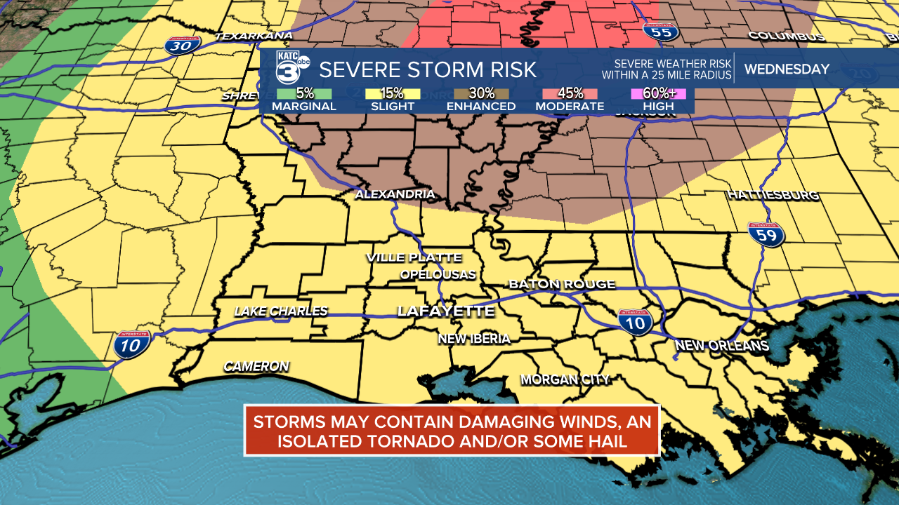
The tornado risk looks to be lower, but it's not zero.
![tornado risk.png](https://ewscripps.brightspotcdn.com/dims4/default/f594a46/2147483647/strip/true/crop/1280x720+0+0/resize/1280x720!/quality/90/?url=http%3A%2F%2Fewscripps-brightspot.s3.amazonaws.com%2Ffa%2F6e%2Fe35daa044dcba2dbc994274b90f7%2Ftornado-risk.png)
This time around, the severe weather risks will be significantly higher from the northern part of Louisiana on northward.
![damaging wind.png](https://ewscripps.brightspotcdn.com/dims4/default/58ee6ef/2147483647/strip/true/crop/1280x720+0+0/resize/1280x720!/quality/90/?url=http%3A%2F%2Fewscripps-brightspot.s3.amazonaws.com%2Fbf%2F1c%2Fa35f693d4e10b943ca716a56f7b9%2Fdamaging-wind.png)
![hail.png](https://ewscripps.brightspotcdn.com/dims4/default/d0adecd/2147483647/strip/true/crop/1280x720+0+0/resize/1280x720!/quality/90/?url=http%3A%2F%2Fewscripps-brightspot.s3.amazonaws.com%2F03%2F4a%2F3b11edd6492993d8e548a6378093%2Fhail.png)
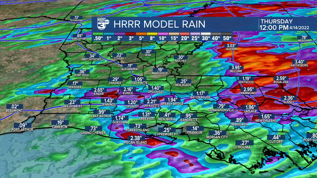
Per the HRRR model, prime-time for the best chance of storms in Acadiana looks to be this Tuesday evening, and then again into Wednesday afternoon/evening.
![hrrr tue.gif](https://ewscripps.brightspotcdn.com/dims4/default/1b623e1/2147483647/strip/true/crop/736x404+0+0/resize/736x404!/quality/90/?url=http%3A%2F%2Fewscripps-brightspot.s3.amazonaws.com%2Fd9%2F2c%2Fc7a4cd0547919290588b952a6909%2Fhrrr-tue.gif)
Temperatures will hover and hold in the lower 70s tonight and should max out in the upper 70s tomorrow due to plenty of cloud cover.
![Acadiana Wind Gust Extended HRRR.png](https://ewscripps.brightspotcdn.com/dims4/default/bef7022/2147483647/strip/true/crop/1280x720+0+0/resize/1280x720!/quality/90/?url=http%3A%2F%2Fewscripps-brightspot.s3.amazonaws.com%2Fe1%2Fa6%2F1f51a1b24b69973d9ee9f1677865%2Facadiana-wind-gust-extended-hrrr.png)
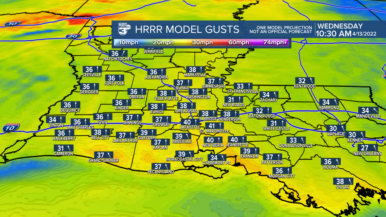
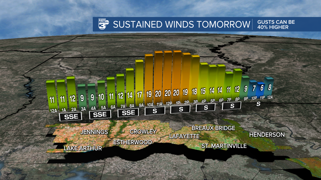
In addition, breezy southerly winds will continue overnight into Wednesday with gusts likely approaching the 35-40 mph range from late Wednesday morning into the mid-afternoon.
![Micro_Climate_Winds_Lafayette_1.png](https://ewscripps.brightspotcdn.com/dims4/default/5903c7e/2147483647/strip/true/crop/1280x720+0+0/resize/1280x720!/quality/90/?url=http%3A%2F%2Fewscripps-brightspot.s3.amazonaws.com%2F01%2F01%2F120f233a421c87ec615af546863b%2Fmicro-climate-winds-lafayette-1.png)
Accumulated rainfall through Wednesday night looks to be in the 1-2" range, but isolated heavier amounts will be possible especially to Acadiana's north and east.
![Extended HRRR Accumulation Acadiana.png](https://ewscripps.brightspotcdn.com/dims4/default/935cb60/2147483647/strip/true/crop/1280x720+0+0/resize/1280x720!/quality/90/?url=http%3A%2F%2Fewscripps-brightspot.s3.amazonaws.com%2F1c%2F5e%2Fe59548974ca58e3ea821ac32fc0e%2Fextended-hrrr-accumulation-acadiana.png)
Drier conditions are expected to return to Acadiana Thursday but some showers are back into the forecast and into Easter Weekend.
See the KATC 10 Day Forecast for the latest.
------------------------------------------------------------
Stay in touch with us anytime, anywhere.
To reach the newsroom or report a typo/correction, click HERE.
Sign up for newsletters emailed to your inbox. Select from these options: Breaking News, Evening News Headlines, Latest COVID-19 Headlines, Morning News Headlines, Special Offers