


A good chance of showers and storm is back in the forecast for Acadiana for the rest of the week while the tropics appear to be ramping-up again, with a potential system likely to head toward the Gulf of Mexico by early next week.
Scattered showers and storms can be expected early Tuesday evening before they dissipate with the loss of daytime heating within an hour or two after sunset.

Deeper tropical moisture and atmospheric instability associated with a weak inverted trough (disturbance) will slide slow westward across the Northern Gulf Coast for the rest of the week leaving us with a good chance (near 60%) of scattered, primarily daytime showers and storms through the end of the week.
Temperatures will likely top out in the mid-90s Wednesday but they should edge closer to the lower 90s, perhaps the upper 80s Thursday and Friday.

This weekend should see rain chances easing a little closer to 40-50% but we'll also be monitoring the Gulf of Mexico for a potential system that could emanate from the Northwest Caribbean.
The National Hurricane Center (NHC) is watching three potential trouble spots in the Atlantic Basin, but of greatest interest to us is a tropical wave that was located in the East-Central Caribbean between the Dominican Republic and Venezuela Tuesday.
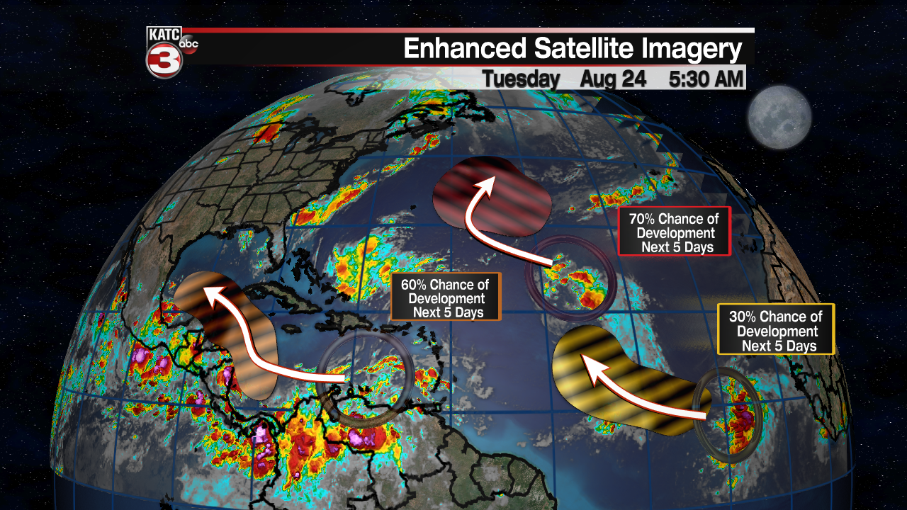
Prospects continue to increase for this system to get better organized and perhaps become a tropical depression or storm before the end of the week somewhere in the extreme Western/Northwestern Caribbean.
Thereafter, the system is expected to cross the Yucatan Saturday and emerge in the Southwestern Gulf of Mexico Sunday.
A tropical storm, perhaps a hurricane threatening the Western Gulf States of Texas and Louisiana is possible by Monday or Tuesday of next week.

The Euro model today is the "outlier" on the possible forecast track toward Louisiana, but yesterday it was showing a Texas threat when the GFS and other models were pointing more toward Mexico.
Today most models have been indicating a Texas impact but the Euro model cannot be discounted at this time.
At the very least some tropical impacts may possible for Louisiana and Acadiana early to mid-next week, including the possibility elevated tides and the chance of tropical rains.
While a named tropical storm is looking likely in the Gulf, it is also the time of year and the set-up could set the stage for a hurricane...with a potential higher than just a Category 1 storm also possible.
It remains however, too early for any more specific details at this time so stay tuned.
Next names on the NHC Atlantic list are Ida & Julian...
------------------------------------------------------------
Stay in touch with us anytime, anywhere.
To reach the newsroom or report a typo/correction, click HERE.
Sign up for newsletters emailed to your inbox. Select from these options: Breaking News, Evening News Headlines, Latest COVID-19 Headlines, Morning News Headlines, Special Offers
