


After a week of sunny, dry and 90° plus heat in Acadiana, a brief pattern change is in the forecast into Saturday.
In the very near term, scattered showers and a few stronger thunderstorms will be possible across the area Friday evening with most activity tapering by 10 pm. Latest Power Doppler 3.
Like Friday, expect mostly sunny skies Saturday with temperatures reaching the lower 90s prior to scattered afternoon and early evening showers and storms dropping southward across the region.

Rain chances will be in the 50-60% range later Saturday afternoon into the evening hours, but will be closer to 20% earlier in the day.
Any storms in the near term and Saturday will be capable of producing strong and gusty winds, frequent cloud to ground lightning and locally heavy downpours.

Wind gusts in the 40-45 mph range or more could be possible in stronger storms...there will be a marginal risk of severe storms (5%) capable of producing better than 55 mph winds into Saturday.
More stable atmospheric conditions Sunday should reduce Acadiana's rain chances closer to 20%.

Temperatures are expected to continue to push into the lower 90s this weekend, with our stretch of 90° plus heat likely continuing all next week.
You may remember that last year, due to a very wet May and June, Lafayette didn't reach 90° until June 9th.
This year, we look to have at least twenty 90° days before June 9th...chalk both years up to meteorological variability, and the fact that the Gulf of Mexico continues its streak of well above normal sea surface temperatures as compared with the 20th century average.
And to add insult to injury, Acadiana's dew points and humidity will be on the rise deeper into next week with the weather pattern perfectly normal for July or August, but not mid-May.
See the KATC 10 Day Forecast for the latest.
Meanwhile in the tropics, our longer range models continue to show deep tropical moisture pooling in the Northwest Caribbean into Central America, with the the GFS indicating the possibility of some development in the 7-10 day period while the Euro sends the deep moisture toward the Eastern Pacific.
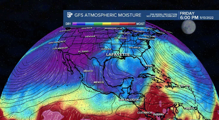
At this point, it is way too early to speculate on the tropics beyond a 7 day forecast, so no issues, nor any expected for now.
We are however, closing into that time of year.
And anything beyond a 10 Day forecast in the tropics is just fantasy land and cannot be trusted or given any gravity...stay with trusted sources of weather, especially when it comes to social media!
Finally in the good news department: Finally, tree pollen has dropped into the low category in Acadiana...your sinuses can rejoice!

------------------------------------------------------------
Stay in touch with us anytime, anywhere.
To reach the newsroom or report a typo/correction, click HERE.
Sign up for newsletters emailed to your inbox. Select from these options: Breaking News, Evening News Headlines, Latest COVID-19 Headlines, Morning News Headlines, Special Offers
