


Acadiana will continue to enjoy more spring-like temperatures through mid-week, but another storm system promises a good chance of strong to possibly severe storms by Wednesday afternoon and/or evening.
In the near term, southeasterly winds will allow for a milder night through Tuesday morning as moisture, clouds and perhaps some patchy fog arrive by morning.

Lows will be in the mid-50s overnight, probably occurring within a few hours after midnight.
Tuesday will bring more spring-like temperatures with readings topping out well into the mid-70s in spite of increasing cloud cover.
Tuesday will be a mostly cloudy day, but a few intervals/periods of sun will be possible.
With the return flow from the Gulf, there could be a spotty shower or two Tuesday, but chance of getting wet will be limited to near 10% for most of us.
Even milder conditions are anticipated Tuesday night into Wednesday morning with temperatures hovering closer to the low-mid 60s along with a chance of some foggy conditions developing after midnight.

Expect breezy and mild conditions into Wednesday as our next storm system approaches from the west.
Showers and thunderstorms will become likely across Acadiana primarily Wednesday afternoon into the early evening.
The Storm Prediction Center (SPC) has all of Acadiana hatched in for a marginal, level 1 out of 5, for a few isolated severe storms for Acadiana.

The primary severe weather threat should it materialize, would be for storms that may contain damaging winds, perhaps an isolated tornado or two.
The SPC has also indicated in their discussion that there could be an upgrade to a higher "slight risk", level 2 out of 5, within the marginal risk area with their next forecast update for Wednesday...stay tuned.
Rain and storms should be moving along at a good clip Wednesday so flooding is not expected.

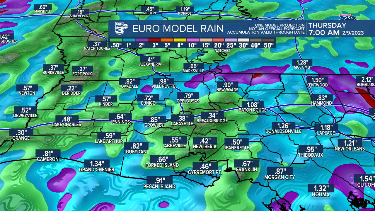
For now, rain totals appear to be in the 1/2-1" range but could be double that in a few isolated spots...
Storms are expected to end Wednesday night with a nice and seasonable day anticipated Thursday.
A secondary frontal system arrives Thursday night into Friday, but this system will have very little moisture to work with, so no rain chances with that feature for now.
As a result, a winter chill will return to the area Friday into the weekend but we should stay dry...chilly for the Mardi Gras parades though into the weekend so dress warmly!
Look for another warm-up early into the following week with potentially stormy conditions returning again next Wednesday.
See the KATC 10 Day Forecast for the latest.
------------------------------------------------------------
Stay in touch with us anytime, anywhere.
To reach the newsroom or report a typo/correction, click HERE.
Sign up for newsletters emailed to your inbox. Select from these options: Breaking News, Evening News Headlines, Latest COVID-19 Headlines, Morning News Headlines, Special Offers
