


Despite some lingering cloud cover for portions of Acadiana Friday, a mostly sunny and seasonably cool weekend is still on tap for the region.
It was a tale of two Acadiana's Friday with clouds and chilly temperatures in the 50s lingering from Lafayette eastward, while unabated sunshine and temperatures in the low-mid 60s were found to the west.

The sun continued to burn-off the cloud cover late Friday afternoon, but those clouds may redevelop for some again overnight into Saturday morning.

Both the HRRR and GRAF models suggests that even where clouds burn-offed Friday afternoon, they may try to reform and move in from the east by morning.
Any early clouds should burn-off more quickly for our Saturday afternoon.

We could see the same situation developing again for some portions of Acadiana late Saturday night into Sunday morning, but the clouds, or perhaps more of a fog situation, will burn-off for good (and faster), at least for a couple of days thereafter.
So we'll call it a "mostly sunny and cool weekend" for most of Acadiana with the caveat of some periods of lingering cloud-cover for the eastern parishes, especially Eastern St Landry, St Martin, Iberia and St Mary parishes.
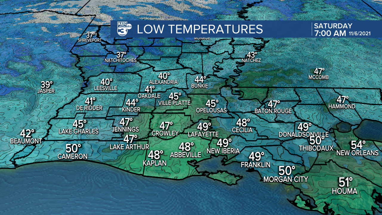
Lows overnight through Saturday morning will vary with any cloud cover, with mostly mid-40s where it will be clear to the upper 40s to near 50° where clouds persist or redevelop.
Temperatures Saturday afternoon will push back into the upper 60s.

It should be a little chillier Saturday night into Sunday morning with readings closer to the low-mid 40s.

Mostly sunny skies Sunday should warm the area back closer to the lower 70s for the afternoon.

Mostly sunny and warmer conditions and moderating temperatures are anticipated early to mid-week before our next "weather-maker" in the form a cool front arrives next Thursday or Thursday night.
We could see some shower activity, perhaps an isolated storm Thursday...but do not count on any significant rainfall.
And with any luck, the following weekend looks fair and cool again!
See the KATC 10 Day Forecast for the latest.
------------------------------------------------------------
Stay in touch with us anytime, anywhere.
To reach the newsroom or report a typo/correction, click HERE.
Sign up for newsletters emailed to your inbox. Select from these options: Breaking News, Evening News Headlines, Latest COVID-19 Headlines, Morning News Headlines, Special Offers
