


We are now about less than 12 hours away from the onset of impactful winter precipitation across Acadiana.
We had a little taste of it this morning across parts of the area with freezing rain/drizzle in spots, but nothing that presented too much in the way of any issues.
Temperatures have remained in the 30s, but those wind chills were down into the 20s.

A pretty impressive upper-level feature will approach the region tonight which will provide atmospheric lift and high precipitation chances.
Temperatures will be falling into the mid-upper 20s overnight tonight and into Monday morning.
You may be wondering with temperatures that cold, why aren't we expecting snow?
Well, the reason is that we are going to have a warm layer of air aloft (~900-700mb), so as the snow falls through the column, it will melt.
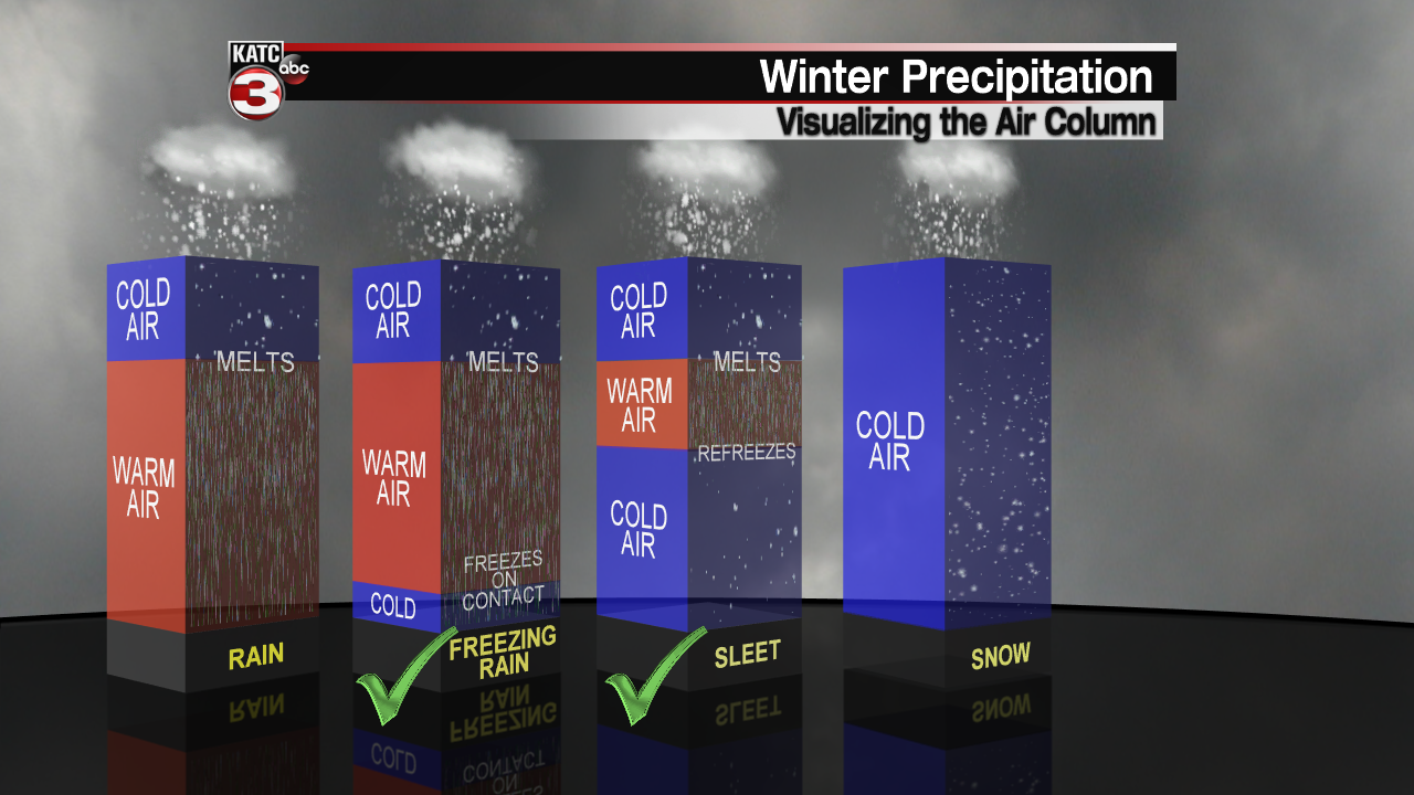
However, it is then going to encounter those very cold temperatures at the ground and actually re-freeze on contact with the surface.
That is a textbook freezing rain scenario.
Unfortunately, that is the most dangerous type of winter precipitation because now we are talking icy road conditions as well as ice coating on tree limbs and power lines.
Furthermore, I would not be surprised to see some sleet mixing in as well, especially as that warm layer begins to shrink later in the morning.
Impressive snow accumulations look to be setting up for the northern parts of the state.
Some snowfall will be possible for extreme northwestern portions of the region, but most of us will only see freezing rain/sleet.
Bulk of the precipitation should start to exit the region by Monday afternoon as temperatures remain in the 20s.
*So, to be completely blunt here... Travel and driving conditions are going to become quite dangerous/treacherous and nearly impossible. There's no doubt about it at this point.
I'd argue starting late tonight (pre-dawn), roadways, especially those bridges and overpasses, will be an issue to travel on.
It only gets more hazardous through Monday morning as that ice begins accumulating.
It is likely that travel stays dangerous all the way through Wednesday morning considering temperatures may not get above freezing until midday on Wednesday.
Make sure to plan accordingly and always heed the advice from law enforcement officials.
Models continue to show ice accumulations of .25"-.5+" across the area.

Mind you that when we start talking of accumulating ice >.25", that is when we have to start worrying about some tree limbs breaking and perhaps some power outages as well.

Also, the model graphics above are not taking into account sleet accumulations, so total accumulations (adding up both freezing rain/sleet amounts) may actually be even higher than shown there.

Always a tough task to nail down the specific/exact numbers when we are dealing with winter precipitation events, but it is important to take into account all of the models and make a reasonable forecast from that.
Our next issue is going to be behind this storm system as temperatures begin to plunge into the teens overnight Monday into Tuesday morning.
We are forecasting temperatures to be in the middle-upper teens with wind chills in the single digits!
This is certainly pipe-busting type cold.
Hopefully, you have already took the necessary precautions to protect your pipes, but here are some tips and reminders:

Additionally, remember that anything iced over (roads, bridges) will remain that way until temperatures can climb above freezing.
Again, that may not occur until Wednesday midday, so keep that in mind and plan accordingly.
We get close to 50 degrees on Wednesday before our next system will begin to approach late Wednesday into Thursday morning.

This one is shaping up to be mainly a rain event across Acadiana with the bulk of any winter precipitation likely staying off to our north.
We will watch the trends on this one in the days ahead.
Furthermore, will be eyeing yet another hard freeze on Friday morning behind the system as temperatures head for the mid-20s.
FINALLY, a gradual warm-up is expected into the follow weekend with full sunshine returning Friday and Saturday.
In the short-term, stay safe and warm out there!
