


In advance of the risk of severe storms across Acadiana Wednesday, the National Weather Service has issued a High Wind Warning for the entire area...and a tornado watch will be very likely for the area as well by midday Wednesday.

A strong storm system with plenty of severe weather dynamics in place will impact Acadiana into Wednesday afternoon.

Latest guidance from the Storm Prediction Center (SPC) has all of Acadiana hatched in for an enhanced risk of severe storms (level 3 out of 5), with the northern parishes hatched in for a moderate (level 4 out of 5) risk.

Storms containing damaging winds in excess of 75 mph will be possible in supercell storms that may form, along with the possibility of isolated, strong tornadoes, of EF2 strength (111-135mph) or greater developing and impacting the region.
The greatest risk of severe storms remains across the northern Acadiana parishes, in the moderate risk zone, while the rest of us will be in an enhanced risk zone.

The specific risk of tornadoes, especially strong EF2 or greater twisters will exist from the northern portions of Acadiana northeastward into the central & the northeastern part of the state and into Mississippi.

But like last week, there is still a decent chance of a couple of isolated tornadoes in the enhanced zone...the zone where New Orleans/Arabi was last week.
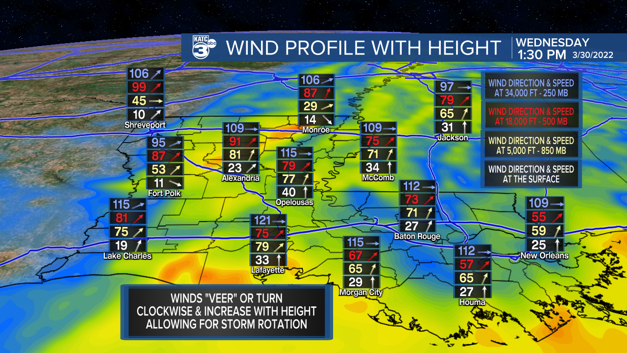
The wind dynamics aloft and at the surface will be stronger than last Tuesday's severe weather system, with a low level jet-stream at 5,000 feet near 80 mph...those type of winds could get brought down to the surface in severe cells in addition to being conducive for rotating storms capable of producing isolated tornadoes.

Per the SPC, the risk of damaging winds is roughly 3 times that of isolated intense tornadoes.
And before the storms even arrive, strong and gusty winds will amplify around late morning into the afternoon hours with frequent gusts likely approaching 50-55 mph.

Thus the National Weather Service has issued a High Wind Warning for all of Acadiana Wednesday in anticipation of those strong winds...which could result in some sporadic power outages. This is the first wind warning issued by the Lake Charles Office for the area since November of 2015.


Bottom line, stay weather aware Wednesday and with KATC, katc.com and social media for live updates into Wednesday afternoon.
Storms will end by 5-6 pm for the southeastern parishes of the area with a couple of nice days to follow.
Some showers and a storm or two returns Saturday, with our next weather-maker (possibly more strong storms) possibly shaping up for next Tuesday.
See the KATC 10 Day Forecast for the latest.
Later Doppler Updates here.
------------------------------------------------------------
Stay in touch with us anytime, anywhere.
To reach the newsroom or report a typo/correction, click HERE.
Sign up for newsletters emailed to your inbox. Select from these options: Breaking News, Evening News Headlines, Latest COVID-19 Headlines, Morning News Headlines, Special Offers
