


Once again Acadiana will be facing the threat of strong to severe thunderstorms into Tuesday afternoon as yet another potent storm system rolls through the Plains overnight into the Southeast U.S. Tuesday.

This system will drag a cool front through the area Tuesday night, and with very warm and humid conditions out ahead of the frontal system, the threat of severe storms should be more substantial than the threat the area was under this past weekend.
The Storm Prediction Center (SPC) has much of Central and Eastern Louisiana into Mississippi and Alabama under an "enhanced risk", a level 3 out of 5, of severe storms impacting the region Tuesday....with northern portions of Acadiana (Evangeline, St Landry & Avoyelles) within that enhanced risk.

The SPC has the rest of Acadiana primarily under a slight risk, while the risk down toward the coast is marginal.
Nonetheless, like so many potential weather threats to the area, Acadiana will be in the region where storms will likely be initiating Tuesday afternoon...those storms will likely intensify as they travel northeastward resulting in a possible significant threat of tornadoes into Mississippi and eventually Alabama into Tuesday night.

Any storms that do get going locally may also have the capability of producing damaging winds and hail.

Prime-time for the severe storm threat for Acadiana looks to be between 2pm and 7pm, give or take an hour or two.

The highest risk of severe storms locally will likely occur in Central Louisiana and then onto Mississippi, but models also show some fairly significant storm dynamics into Eastern Louisiana late Tuesday afternoon into Tuesday evening.

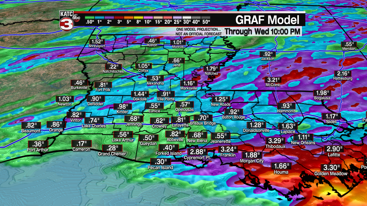
Fortunately, any storms Tuesday will be moving at a quick pace so rainfall totals should be generally an inch or less...with higher totals likely manifesting toward Eastern Louisiana.
In the near term, look for warm and humid conditions for the area overnight...and with dew points already in the mid-70s Monday afternoon, we will not be any cooler that the mid-70s for our Tuesday morning low.
These dew points also point to a much more unstable lower atmosphere ahead of the storms into Tuesday.
In addition, while most of Tuesday should be cloudy and breezy, some breaks in the clouds from late morning into the afternoon could add to our atmospheric instability feeding and helping to intensify the expected storms.
Highs Tuesday will reach the mid-80s.
While some storms may linger down toward the coast Tuesday night into Wednesday, it appears that most of us will see partly sunny skies, cooler temperatures and more comfortable humidity working its way into the region by Wednesday afternoon.
The forecast for the rest of the week into most of the weekend looks great for Acadiana with mostly sunny skies accompanied by cooler nights, into the upper 50s to lower 60s, for a few nights prior to the weekend.
Warming temperatures and higher humidity along with some shower activity is expected to return by early to mid next week.
See the KATC 10 Day Forecast for the latest.
------------------------------------------------------------
Stay in touch with us anytime, anywhere.
To reach the newsroom or report a typo/correction, click HERE.
Sign up for newsletters emailed to your inbox. Select from these options: Breaking News, Evening News Headlines, Latest COVID-19 Headlines, Morning News Headlines, Special Offers
