


After a couple of very pleasant weather days across Acadiana, conditions will turn toward an unsettled and potentially stormy pattern into Wednesday night.
In the near term, expect fair skies through much of Tuesday evening with some clouds returning by morning.
Temperatures Wednesday morning will be milder than the last couple of nights courtesy of southeasterly winds, with lows closer to the low-mid 60s.
Yet another potent storm system will tear through Northeast Texas, Northern Louisiana, into Mississippi and portions of the Deep South Wednesday into Thursday.
This will make for a windy day across Acadiana Wednesday with partly sunny skies early becoming mostly cloudy for the latter part of the afternoon.
High temperatures Wednesday will be in the low to mid-80s.
And like last several systems it will get windy from mid-Wednesday morning into the afternoon and evening feeding into the big storms that will be likely firing to our north.
Gusts to 30-35 mph will be likely for a good portion of Acadiana Wednesday afternoon/evening, with a few higher gusts that could be up to 40 mph.
As a result, expect tides along the coast to briefly to increase again to 1-2 feet above normal into Wednesday night.
It appears that most of Wednesday will be dry for Acadiana but the chance of scattered showers and a few storms will gradually increase into the latter part of the afternoon/evening hours, near 40%, and will be maximized overnight htrough near daybreak Thursday to near 70-80%.
The Storm Prediction Center (SPC) has Acadiana hatched in for marginal to slight risk of severe storms primarily for Wednesday night and continuing into very early Friday.
Storms could contain damaging winds, hail and perhaps a few tornadoes...but the greatest risk of damaging storms in Louisiana will be confined to the central and northern part of the state....and then into Mississippi and points east into Thursday...these folks have not been able to catch a break.
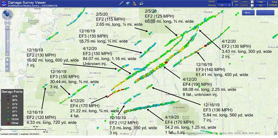
Just look at the number of long-tracked and intense tornado paths plotted from this winter to date below!
A substantial severe weather threat will shift into the Southeastern U.S. into Thursday afternoon and evening.
Locally, the threat of showers and storms will end for Acadiana by midday Thursday with sun likely to return for the latter part of the afternoon.
Thereafter it looks like smooth sailing in the weather department into the weekend, and hopefully for much of next week.
See the KATC 10 Day Forecast for the latest.
------------------------------------------------------------
Stay in touch with us anytime, anywhere.
To reach the newsroom or report a typo/correction, click HERE.
Download our free app for Apple, Android, Roku and Amazon devices.
Sign up for newsletters emailed to your inbox. Select from these options: Breaking News, Evening News Headlines, Latest COVID-19 Headlines, Morning News Headlines, Special Offers
