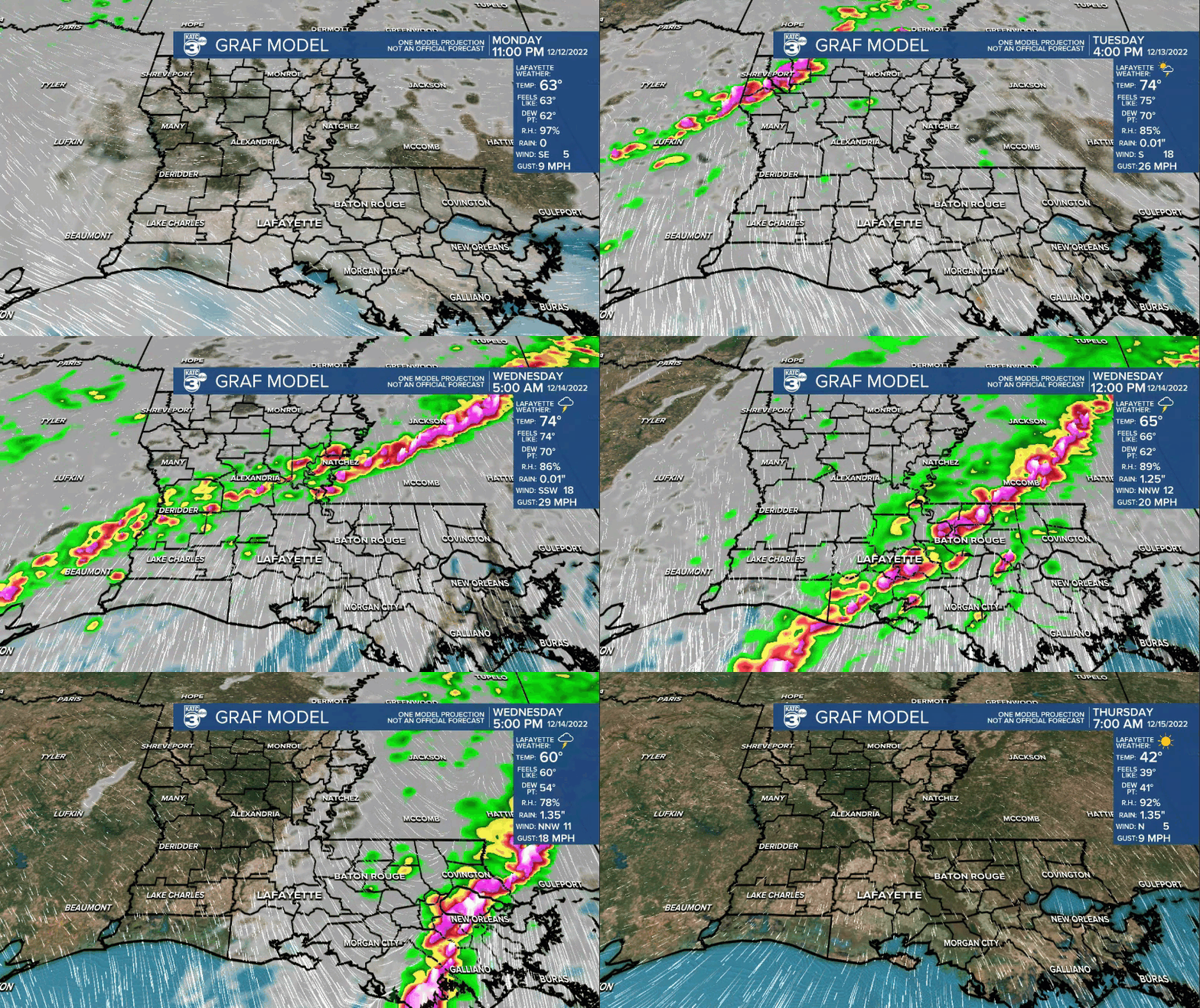
An active period of weather is expected to unfold across Acadiana by Tuesday evening and continue through midday Wednesday with the threat of severe storms and flooding rainfall.

A potent storm system expected to produce blizzard conditions in the Northern US and the threat of severe storms and heavy rainfall in the south will be advancing out of the Rockies Tuesday and will be accompanied by a dynamic wind pattern aloft across the region.

Thus the Storm Prediction Center (SPC) has the region highlighted for the threat of severe storms Tuesday into Wednesday with the primary severe weather threat locally in Acadiana primarily from Tuesday evening through midday Wednesday.

Per the SPC, Acadiana is hatched in for a slight to enhanced risk (level 2 and 3 out of 5) for severe storms that may be capable of producing damaging winds, isolated tornadoes and hail.

There will be strong vertical shear and veering of winds with height in the area starting by Tuesday evening that could allow for rotating, discrete (loner) super cell storms to get going for northwestern sections of Acadiana as early as late afternoon Tuesday.

The pattern will amplify and slide eastward into Tuesday night.

The parishes at greatest risk of severe weather storms looks to be from Allen, Evangeline and St Landry parishes on northward.
The severe weather dynamics will increase across the region Tuesday evening/night with a commensurate increase in our rain chances.

The SPC keeps the eastern half of Acadiana under a slight risk of severe storms through midday Wednesday.
Models show a squall line developing in the region late Tuesday night into Wednesday morning with several of our models looking to slow things down with a secondary squall developing behind the initial squall line into the daylight hours Wednesday.

And because of this slow movement and potential for "training" or storms repeating over the same area, there could be the risk of heavy rains and some localized flooding especially into Wednesday morning.

Therefore, the National Weather Service has issued a flash flood watch for all of Acadiana from Tuesday evening through Wednesday afternoon.

Our high resolution models show most areas will see roughly 1-3" but isolated spots of 2-4" or more will be quite possible.

The Euro Model has been most concerning and more persistent on the possibility of flooding showing more widespread rains of 4-6"...for now it's best to average the model forecasts rather than stick with any one particular model or model run time.

In addition to the Flood Watch, expect several tornado watches in the Acadiana region as early as late Tuesday afternoon, most likely into Tuesday evening and possibly continuing through Wednesday morning.
Breezy, much cooler weather will return to the area later in the week..it will stay chilly with the possibility of some showers into the weekend.
And the cool pattern will be here to stay, with both the GFS & Euro models showing the possibility of the coldest air of the season arriving sometime between December 22-24th...

Now only if there could be some moisture in the region, if and when that cold air arrives...mind you the statistical chance of a white Christmas in Acadiana is 0.05%...it's not zero, but it's a 1 in 2000 chance...still, better odds than winning the lottery!
See the KATC 10 Day Forecast for the latest.
------------------------------------------------------------
Stay in touch with us anytime, anywhere.
To reach the newsroom or report a typo/correction, click HERE.
Sign up for newsletters emailed to your inbox. Select from these options: Breaking News, Evening News Headlines, Latest COVID-19 Headlines, Morning News Headlines, Special Offers


