


Seasonably cooler conditions are expected for Acadiana over the next 36-48 hours in the wake of Tuesday morning's cool front.
Thereafter, warmer temperatures and the risk of scattered showers, perhaps a few storms should increase by the latter part of the weekend.
In the near term, expect breezy and cooler conditions with temperatures dropping into the low-mid 50s by Wednesday morning...which in fact, is very close to normal for this time of year.

Wednesday will likely start out with mostly cloudy skies (and mostly high clouds) as a weak disturbance rolls in from the west-northwest.

This disturbance may produce some virga (light rain that evaporates before reaching the ground) and or a few light sprinkles/showers primarily during the morning hours Wednesday.
But rain chances early Wednesday should be less than 20% and mainly focused toward the western and coastal parishes of our area.
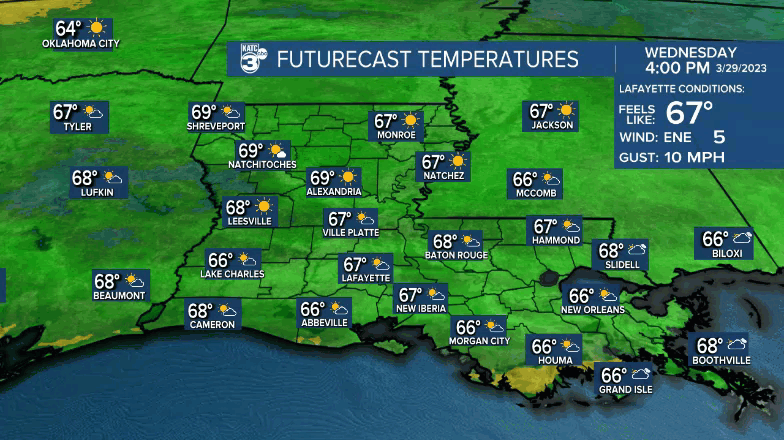
More sun is anticipated Wednesday afternoon which should allow our temperatures to rise and top out in the upper 60s to lower 70s...some 5 degrees below normal for the time of the year.
Another cool night is expected Wednesday night with temperatures dropping into the upper 40s to lower 50s for most areas.
Thursday should be the nicest day for the week with fair to partly cloudy skies following the cool start with temperatures rising into the upper 70s to near 80° for the afternoon.
Friday into the early part of weekend we expect more clouds, and at worst, low end rain chances (at 20%) through Saturday.

By Sunday it appears that a series of disturbances combined with a waffling frontal boundary should generate a better chance of scattered showers and a few storms late Sunday into Monday.
Next week looks somewhat unsettled with some rain chances, and perhaps a few days where it may feel more like summer as humidity rises into the uncomfortable range for a few days.
See the KATC 10 Day Forecast for the latest.
Climate Notes:
It is appearing very likely that a transition to an El Niño on the way for this summer and tropical season.
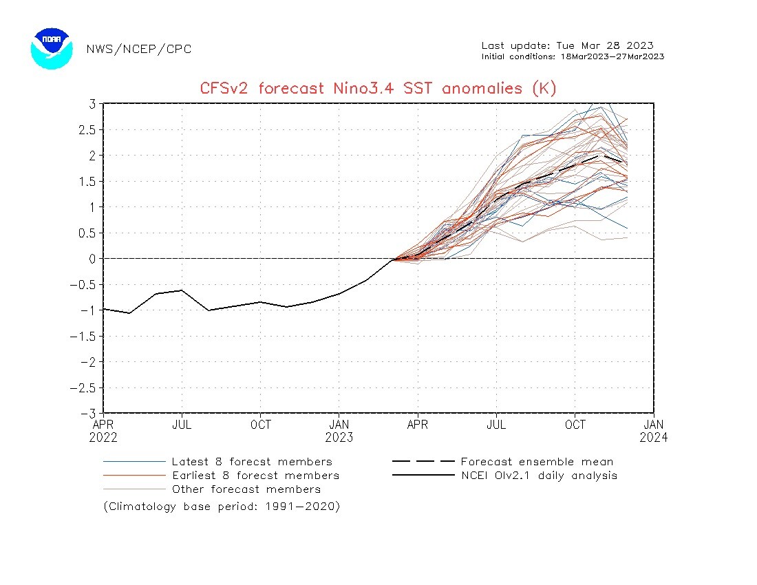
Typically El Niños increase wind shear over the Caribbean and the tropical Main Development Region (MDR) during hurricane season, limiting the total number of storms, and sometimes intensity of the storms that do develop.
However, from a climatological perspective in the Gulf Of Mexico, it means little difference to the "net" potential activity.
It does mean that most action in the Gulf may be homegrown in the Gulf or off the Southeast U.S. Coast, with fewer storms coming into the Gulf from the Caribbean...but a few still can slip through the pattern.
Bottom line: as always, BE EQUALLY PREPARED every hurricane season, busy forecast or not...we are two months away from official beginning of that season.
------------------------------------------------------------
Stay in touch with us anytime, anywhere.
To reach the newsroom or report a typo/correction, click HERE.
Sign up for newsletters emailed to your inbox. Select from these options: Breaking News, Evening News Headlines, Latest COVID-19 Headlines, Morning News Headlines, Special Offers
