


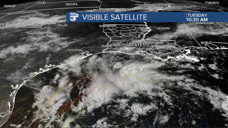
A weak area of low pressure roughly 200 miles south of Cameron Parish will continue to influence Acadiana's weather in the days ahead, eventually delivering on a few days of enhanced shower and thunderstorm activity.
Daily rain chances and the risk of scattered, afternoon showers and thunderstorms this week should increase...if not for Wednesday, more likely for Thursday and perhaps Friday.

The disturbance in the Gulf will drift toward Texas over the next couple of days...and per the NHC, the system has a 40% chance of becoming a tropical depression prior to landfall Thursday.

After landfall it is expected to drift north for a few days, then east, and perhaps again to the south skirting around Louisiana.
Eventually it will aid in generating better Acadiana rain chances in the days perhaps up to the week ahead...but not everyday will see enhanced rain chances.

Overall, although widespread storms have not materialized over Acadiana over the last couple of days (there's still the risk of scattered storms into this Tuesday evening), rain chances should inch closer to 50-60% later this week.
Scattered afternoon storms will likely stay in the forecast for the July 4th holiday weekend, with rain chances easing closer to 30% by Sunday and Monday.
Rain chances could increase again later into next week, as the same Gulf disturbance could impact the area...what comes around appears to be going around.
At this point, rainfall totals do not appear to be a concern for Acadiana in the days ahead with roughly an inch or two possible accumulating over the next week plus with the threat of much heavier rainfall for the Gulf of Mexico and portions is next over the next 2-4 days.

See the KATC 10 Day Forecast for the latest.
Meanwhile in the rest of the tropics, Potential Tropical Cyclone #2 near the southern Windward Islands should become Tropical Storm Bonnie in the next day or two as long it stays north of land in South America.

PTC2 still has some hurricane potential prior to threatening Central America Friday into the weekend.
------------------------------------------------------------
Stay in touch with us anytime, anywhere.
To reach the newsroom or report a typo/correction, click HERE.
Sign up for newsletters emailed to your inbox. Select from these options: Breaking News, Evening News Headlines, Latest COVID-19 Headlines, Morning News Headlines, Special Offers
