


Acadiana will be treated with one more nice day Wednesday before our next weather-maker arrives Thursday with wind, rain and a few embedded storms likely into Thursday night.
In the near term, expect another chilly night with temperatures generally in the lower-mid 30s by daybreak Wednesday.

There will be the risk of frost Wednesday morning mainly for the northern Acadiana parishes northward into Central Louisiana.
Mostly sunny skies will yield to high clouds Wednesday with highs pushing the mid- to perhaps in some cases, upper 60s (depending on the amount of high clouds).

Clouds will increase Wednesday night holding our temperatures closer to the 50s as southeasterly winds kick in.
As low pressure gets cooking in Texas Thursday gusty southerly winds should increase to 20-30 mph as moisture from the Gulf feeds into the area.

Rain will become likely for most areas by Thursday afternoon, with heavier showers and a few embedded storms a possibility into Thursday night.
Temperatures Thursday will approach 70°, followed by readings pushing the upper 70s Friday before some slight cooling arrives into the weekend.

No widespread severe weather is expected locally but the Storm Prediction Center does have the Acadiana area hatched in for a marginal risk (5% - a level 1 out of 5) for a few isolated severe storms that could produce damaging winds and/or an isolated tornado Thursday.
Any severe weather dynamics should they materialize locally are expected to decrease later into Thursday night.
The greatest risk of severe storms will be toward Southeast Texas during the day Thursday where dynamics will be a little more robust for storm development.

Meanwhile, expect a soaking of roughly 1-2" Thursday afternoon into the night...but then more batches of rain will be possible just about anytime Friday through Saturday, with latest models pointing to highest rain chances Friday morning, then late Friday night and perhaps again Saturday, or more likely, Saturday night.
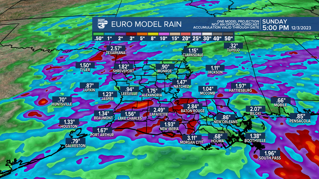
Overall the area should see 1-3" of rain Thursday through Sunday with isolated amounts possibly higher, especially western section of Acadiana into Southwest and Western Louisiana.

Rains should diminish into Sunday but clouds will likely stay through at least Monday.
Another few days of nice weather should follow next week with rain chances possibly ramping back up for next Friday and perhaps, into the following weekend.
See the KATC 10 Day Forecast for the latest.
------------------------------------------------------------
Stay in touch with us anytime, anywhere.
To reach the newsroom or report a typo/correction, click HERE.
Sign up for newsletters emailed to your inbox. Select from these options: Breaking News, Evening News Headlines, Latest COVID-19 Headlines, Morning News Headlines, Special Offers
