


Mostly sunny and milder weather is in the forecast for Acadiana and the region Wednesday, but a frontal system producing shower activity is expected to sweep in from the northwest for Thanksgiving.
In the near term, expect another cool night for the area with temperatures not as chilly as they were last night/Tuesday morning (mid-upper 30s to lower 40s), with Wednesday morning lows closer to the low-mid 40s.

Milder temperatures under mostly sunny skies are forecast for Acadiana Wednesday, accompanied by a pleasant southeasterly breeze into the afternoon.

Those southeasterly winds will hold our temperatures closer to the upper 50s to lower 60s through Thanksgiving morning while also beginning to usher in more clouds.

While Thanksgiving may start off partly cloudy and mild, the chance of scattered showers will be increasing into the afternoon with rain chances up to 70% at this time.

Best chances for rain Thanksgiving will be from mid-afternoon into the early evening hours.
No severe weather nor heavy rainfall is anticipated with system; however, it does appear that we may see more rain out of this frontal system than the last several fronts combined.
Preliminary rain totals look to be closer to the 1/2" range...give or take a quarter of an inch.
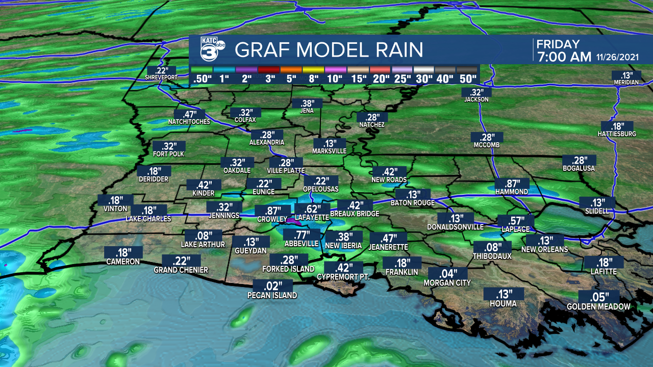
A few isolated spots may see up to an inch of rain, possibly making it the wettest day of the month, considering rain totals for the entire month have been between 1/4 and 1/2"...much below the 3-4 inches we would normally expect through this time in November.
Cooler weather returns to Acadiana Friday into the weekend with fair to skies Friday followed by what could be a relatively cloudy weekend.
An upper disturbance in the Southwest U.S. is expected to slowly meander eastward into this weekend which should in turn produce considerable mid and high level cloudiness Saturday into Sunday.

There looks to be enough atmospheric lift with this feature into Saturday night so some light rain shower activity will be possible at that time.
Thereafter into next week, the weather pattern continues to look like a relatively benign November/early December-like pattern with a fair bit of sunshine at least through mid-week.
See the KATC 10 Day Forecast for the latest.
------------------------------------------------------------
Stay in touch with us anytime, anywhere.
To reach the newsroom or report a typo/correction, click HERE.
Sign up for newsletters emailed to your inbox. Select from these options: Breaking News, Evening News Headlines, Latest COVID-19 Headlines, Morning News Headlines, Special Offers
