


Acadiana will be under the gun for several rounds of showers and storms through Saturday morning that may involve some severe storms per the latest outlooks from the Storm Prediction Center (SPC).

First up will be Wednesday night as storms along a vigorous upper level disturbance will advance southeastward through Louisiana during the evening.
Much of Acadiana (along and north of I-10) is hatched for a slight risk (level 2 out of 5) of severe storms, with the primary local threat being storms that could contain damaging winds...an isolated tornado cannot be ruled out.
Farther south into the coastal parishes, the risk is a lower, at a marginal risk.

The worst of the storms overnight into Thursday morning will likely manifest from Northeastern to Eastern Louisiana, and per usual, into Mississippi where and enhanced, level 3 out of 5 risk of storms will exist. Tornadic activity will be much more likely for these areas to our north and east.
The prime-time "window" for storms in Acadiana appears to be from roughly 10 pm to 2 am (from the northwest to the southeast)...and it appears the greatest risk of strongest storms for Lafayette will be around midnight...give or take an hour.
Storms should clear all if not most of Acadiana by 3-4 am Thursday.
Thereafter, mostly sunny skies should return to the area Thursday with temperatures warming into the low-mid 80s...we could push one of the warmest days so far this spring!
The break Thursday will be short-lived as a series of disturbances will likely head our way into Friday night and continuing into Saturday morning.
The SPC already has all of Louisiana hatched in for a slight risk of severe storms for this period, and an early :"enhanced risk" area, again into Mississippi.
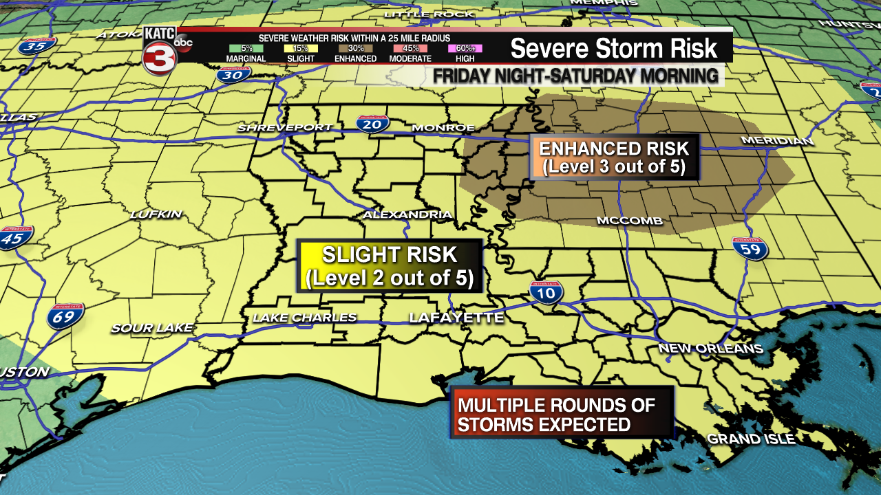
The activity Friday, may involve 2 or 3 impulses that run southeastward across the state...2 of the 3 could impact Acadiana...so stay weather-aware and with KATC, katc.com and KATC social media for the latest on these potentially threatening systems.

At least Acadiana's Sunday and part of Monday are looking nice before an unsettled pattern returns later next week with rain chances, some embedded storms, and cooler temperatures prevailing during the latter part of our 10 Day Forecast.
------------------------------------------------------------
Stay in touch with us anytime, anywhere.
To reach the newsroom or report a typo/correction, click HERE.
Sign up for newsletters emailed to your inbox. Select from these options: Breaking News, Evening News Headlines, Latest COVID-19 Headlines, Morning News Headlines, Special Offers
