


There will be little change in Acadiana's weather pattern through the weekend, but a strong front arriving early Monday will be followed by some of the coolest temperatures so far this fall season.
In the near term, expect mild nights and warm days through Sunday with daytime highs in the mid-upper 80s while overnight lows persist in the upper 60s to lower 70s.

Winds are expected to relax a bit in the days ahead which could lead to some patchy late night and early morning fog...for now, not a major issue but we'll follow the trends in the hours and days ahead.
Expect fair to partly cloudy skies at night and a sun and cloud mix during the day, Friday through Sunday.
A healthy (and relatively rain-less) cool front should arrive to the area around daybreak Monday with breezy and much cooler conditions to follow by Monday evening.

Lingering clouds and perhaps some light rains showers and/or patchy drizzle/mist may follow Monday night into Tuesday, Halloween.
Any precipitation will be very light and should end by Tuesday afternoon/evening.
The big story will be the temperatures after Monday afternoon, with readings dropping into the 50s Monday night and quite possibly staying there all day Tuesday/Halloween.
On top of that, brisk north winds will make for a wind chill for trick or treaters, so layer the costumes for the kids...and adults.
Skies are expected to clear Tuesday night with a sunny and January-like day expected next Wednesday as highs may stay in the 50s again, in spite of full sunshine.
The chillest of the air should arrive Wednesday night into Thursday morning with lows possibly dipping into the upper 30s on the I-10 corridor.
This means that there could be a light frost (mid-30s) in store for the northern-most Acadiana parishes into Central Louisiana come Thursday morning.
Thereafter, a slow warm-up will ensue with highs moderating through the 60s and back into the mid-70s for the following weekend.
Overall the pattern looks quite dry through the next 10-14 days.
See the KATC 10 Day Forecast for the latest.
Drought Update: No surprise here...exceptional drought, level 5 out of 5, expands from 62% to 68% of the state...including all of Acadiana.

98.8% of the state is in the severe, extreme, or exceptional drought category.
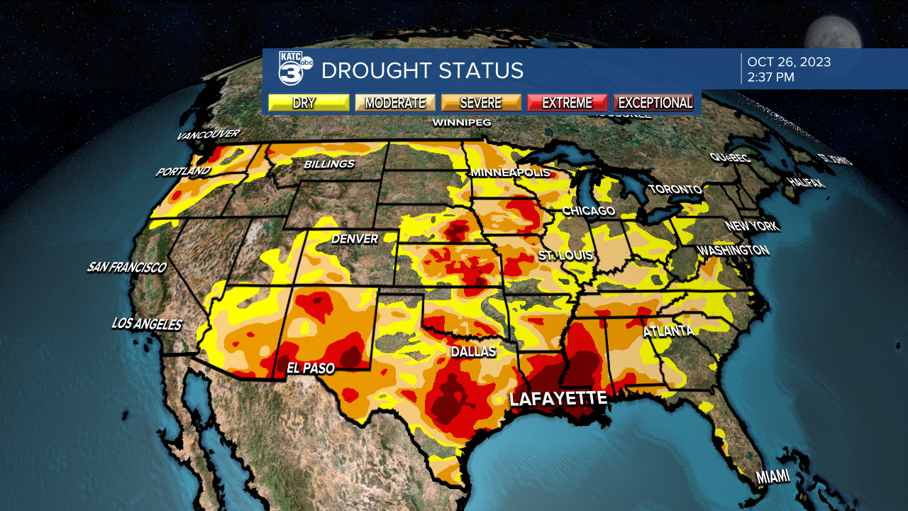
Drier than normal conditions will likely persist well into mid-November, and likely beyond.
------------------------------------------------
Stay in touch with us anytime, anywhere.
To reach the newsroom or report a typo/correction, click HERE.
Sign up for newsletters emailed to your inbox. Select from these options: Breaking News, Evening News Headlines, Latest COVID-19 Headlines, Morning News Headlines, Special Offers
